Country:
 USA
USARegion:
City:
Latitude and Longitude:
Time Zone:
Postal Code:
IP information under different IP Channel
ip-api
Country
Region
City
ASN
Time Zone
ISP
Blacklist
Proxy
Latitude
Longitude
Postal
Route
IPinfo
Country
Region
City
ASN
Time Zone
ISP
Blacklist
Proxy
Latitude
Longitude
Postal
Route
MaxMind
Country
Region
City
ASN
Time Zone
ISP
Blacklist
Proxy
Latitude
Longitude
Postal
Route
Luminati
Country
USRegion
nj
City
holmdel
ASN
Time Zone
America/New_York
ISP
UNITAS
Latitude
Longitude
Postal
db-ip
Country
Region
City
ASN
Time Zone
ISP
Blacklist
Proxy
Latitude
Longitude
Postal
Route
ipdata
Country
Region
City
ASN
Time Zone
ISP
Blacklist
Proxy
Latitude
Longitude
Postal
Route
Popular places and events near this IP address

Clark, New Jersey
Township in Union County, New Jersey, US
Distance: Approx. 722 meters
Latitude and longitude: 40.626,-74.314
Clark is a township in southern Union County, in the U.S. state of New Jersey. As of the 2020 United States census, the township's population was 15,544, an increase of 788 (+5.3%) from the 2010 census count of 14,756, which in turn reflected an increase of 159 (+1.1%) from the 14,597 counted in the 2000 census.

Winfield Township, New Jersey
Township in Union County, New Jersey, US
Distance: Approx. 2451 meters
Latitude and longitude: 40.634885,-74.289847
Winfield Township (also called Winfield Park) is a township in Union County, in the U.S. state of New Jersey. As of the 2020 United States census, the township's population was 1,423, its lowest decennial census and a decrease of 48 (−3.3%) from the 2010 census count of 1,471, which in turn reflected a decline of 43 (−2.8%) from the 1,514 counted in the 2000 census. The township is the sixth-smallest municipality in the state.
Clark Public School District
School district in Union County, New Jersey, US
Distance: Approx. 365 meters
Latitude and longitude: 40.623114,-74.311967
The Clark Public School District is a comprehensive community public school district that serves students in pre-kindergarten through twelfth grade from Clark, in Union County, in the U.S. state of New Jersey. Students from Garwood, attend the district's high school as part of a sending/receiving relationship with the Garwood Public Schools. As of the 2019–20 school year, the district, comprising five schools, had an enrollment of 2,299 students and 184.7 classroom teachers (on an FTE basis), for a student–teacher ratio of 12.4:1.
Rahway High School
High school in Union County, New Jersey, US
Distance: Approx. 1829 meters
Latitude and longitude: 40.610762,-74.293119
Rahway High School is a four-year public high school that serves students in ninth through twelfth grades from Rahway, in Union County, in the U.S. state of New Jersey, operating as the lone secondary school of the Rahway Public Schools. The high school's present location was built in 1941. The school has been accredited by the Middle States Association of Colleges and Schools Commission on Elementary and Secondary Schools since 1931.
Arthur L. Johnson High School
High school in Union County, New Jersey, US
Distance: Approx. 365 meters
Latitude and longitude: 40.623114,-74.311967
Arthur L. Johnson High School is a four-year public high school that serves students in ninth through twelfth grades from Clark and Garwood in Union County, in the U.S. state of New Jersey, operating as the lone secondary school of the Clark Public School District. The school has been accredited by the Middle States Association of Colleges and Schools Commission on Elementary and Secondary Schools since 1963 and is accredited until January 2030. Students from Garwood attend the high school as part of a sending/receiving relationship with the Garwood Public Schools.

Mother Seton Regional High School
High school in Union County, New Jersey, United States
Distance: Approx. 909 meters
Latitude and longitude: 40.62555556,-74.30333333
Mother Seton Regional High School (often referred to as Mother Seton) is an all-girl Catholic high school located in Clark, in Union County, New Jersey, United States. It is located in the Roman Catholic Archdiocese of Newark. The school has been accredited by the Middle States Association of Colleges and Schools Commission on Elementary and Secondary Schools since 1971.

Shri Swaminarayan Mandir, New Jersey (Colonia)
Hindu temple in New Jersey
Distance: Approx. 1655 meters
Latitude and longitude: 40.6051,-74.3129
The Swaminarayan Mandir, New Jersey (Colonia) is a Swaminarayan temple that comes under ISSO (Nar Narayan Dev Gadi of the Swaminarayan Sampraday), located in the Colonia section of Woodbridge Township in Middlesex County, New Jersey, United States. It was officially inaugurated by Acharya Maharajshree Koshalendraprasad Pande on the 4th of September 2005.
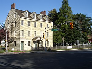
Merchants and Drovers Tavern
United States historic place
Distance: Approx. 2170 meters
Latitude and longitude: 40.61638889,-74.28583333
The Merchants and Drovers Tavern is located at 1632 Saint Georges Avenue in the city of Rahway in Union County, New Jersey, United States. The historic tavern was added to the National Register of Historic Places on November 21, 1978, for its significance in architecture, commerce, and transportation. The exact construction dates of the building have been the source of some historical debate.

John De Camp House
Historic house in New Jersey, United States
Distance: Approx. 2641 meters
Latitude and longitude: 40.62722222,-74.34083333
The John De Camp House is located in Scotch Plains, Union County, New Jersey, United States. The house was built in 1739 and was added to the National Register of Historic Places on December 4, 1973.

Robinson Plantation House
Historic house in New Jersey, United States
Distance: Approx. 706 meters
Latitude and longitude: 40.61361111,-74.31
The Robinson Plantation House is a historic house in Clark, New Jersey built around 1690 on territory that was part of the Elizabethtown Tract, and was once part of Rahway. It was added to the National Register of Historic Places in 1974 as Seventeenth Century Clark House. The owner of the house, Dr.
Rahway Cemetery
Historic cemetery in New Jersey, US
Distance: Approx. 2170 meters
Latitude and longitude: 40.61638889,-74.28583333
The Rahway Cemetery is located along the banks of the Rahway River in Rahway, New Jersey, U.S. Earlier, the land is thought to be owned by the Frazee family with the first burial in 1724 of John Frazee. This land for the cemetery was later acquired by the First Presbyterian Cemetery, which was established circa 1741–1742. It is adjacent to Merchants' and Drovers' Tavern and the Rahway River Parkway.

Robinson's Branch Reservoir
Reservoir in Clark, New Jersey, U.S.
Distance: Approx. 161 meters
Latitude and longitude: 40.62,-74.313
The Robinson's Branch Reservoir is a decommissioned water reservoir in Clark, New Jersey. It is the largest body of water in Union County. Other names for the reservoir include the Clark Reservoir and the Middlesex Reservoir, after its former owner, the Middlesex Water Company.
Weather in this IP's area
clear sky
14 Celsius
12 Celsius
10 Celsius
16 Celsius
1032 hPa
44 %
1032 hPa
1030 hPa
10000 meters
2.57 m/s
30 degree
07:11:53
18:12:22