Country:
 New Zealand
Region:
City:
Latitude and Longitude:
Time Zone:
Postal Code:
IP information under different IP Channel
ip-api
Country
Region
City
ASN
Time Zone
ISP
Blacklist
Proxy
Latitude
Longitude
Postal
Route
IPinfo
Country
Region
City
ASN
Time Zone
ISP
Blacklist
Proxy
Latitude
Longitude
Postal
Route
MaxMind
Country
Region
City
ASN
Time Zone
ISP
Blacklist
Proxy
Latitude
Longitude
Postal
Route
Luminati
Country
NZASN
Time Zone
Pacific/Auckland
ISP
Global-Gateway Internet
Latitude
Longitude
Postal
db-ip
Country
Region
City
ASN
Time Zone
ISP
Blacklist
Proxy
Latitude
Longitude
Postal
Route
ipdata
Country
Region
City
ASN
Time Zone
ISP
Blacklist
Proxy
Latitude
Longitude
Postal
Route
Popular places and events near this IP address

Radio New Zealand
Public-service radio broadcast network
Distance: Approx. 227 meters
Latitude and longitude: -41.285,174.77416667
Radio New Zealand (Māori: Te Reo Irirangi o Aotearoa), commonly known as Radio NZ or simply RNZ, is a New Zealand public-service radio broadcaster and Crown entity that was established under the Radio New Zealand Act 1995. It operates news and current-affairs network, RNZ National, and a classical-music and jazz network, RNZ Concert, with full government funding from NZ On Air. Since 2014, the organisation's focus has been to transform RNZ from a radio broadcaster to a multimedia outlet, increasing its production of digital content in audio, video, and written forms.
New Zealand Geographic Board
New Zealand geographical naming agencies
Distance: Approx. 212 meters
Latitude and longitude: -41.285,174.77444444
The New Zealand Geographic Board Ngā Pou Taunaha o Aotearoa (NZGB) is the authority over geographical and hydrographic names within New Zealand and its territorial waters. This includes the naming of small urban settlements, localities, mountains, lakes, rivers, waterfalls, harbours and natural features and may include researching local Māori names. It has named many geographical features in the Ross Sea region of Antarctica.
Wellington Museum
Museum covering the history of Wellington
Distance: Approx. 221 meters
Latitude and longitude: -41.2853,174.7781
Wellington Museum (formerly the Museum of City & Sea) is a museum on Queens Wharf in Wellington, New Zealand. It occupies the 1892 Bond Store, a historic building on Jervois Quay on the waterfront of Wellington Harbour. In 2013, it was voted by The Times as one of the world's 50 best museums.

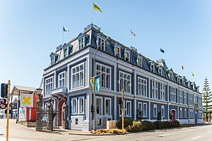
AMP Society Building
Distance: Approx. 133 meters
Latitude and longitude: -41.285401,174.776623
The AMP Society Building is a historic building on Customhouse Quay, Wellington, New Zealand. The Australian Mutual Provident society was founded in 1849 and established a branch on Featherston Street, Wellington in 1871. The AMP Society Building was built in 1928, and features a classical facade of grey New Zealand granite and sandstone from the Hawkesbury River in New South Wales.

Old Bank Arcade
Retail and office complex on a corner site In New Zealand
Distance: Approx. 53 meters
Latitude and longitude: -41.286075,174.776285
The Old Bank Arcade is a retail and office complex on a corner site at Lambton Quay, Wellington, New Zealand. The property consists of four buildings built between 1883 and 1904. The most prominent is the Bank of New Zealand building (no.
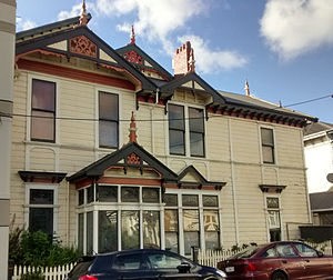
Carrigafoyle, Wellington
Historic building in Wellington, New Zealand
Distance: Approx. 239 meters
Latitude and longitude: -41.286897,174.773187
Carrigafoyle (meaning "on a rock overlooking water") is a historic building in Wellington, New Zealand. The house was designed by Penty & Blake for Robert and Elizabeth O'Connor. Robert's Irish ancestors were said to extend back to Carrigafoyle, County Kerry in Ireland.
Inconstant (ship)
Distance: Approx. 87 meters
Latitude and longitude: -41.28574444,174.77626667
Inconstant was a wooden full-rigged sailing ship built in 1848 at Cape Breton, Nova Scotia which later became known as "Plimmer's Ark" and played an important role in the development of Wellington, New Zealand. The ship's hull remains in Wellington today as an important archaeological site. Built by George Old at Big Bras d'Or, Nova Scotia Inconstant was one of largest wooden ships ever built in Cape Breton Island, Nova Scotia and the largest ship built by Old, a shipbuilder who started with schooners before focusing mainly on brigs.

Stewart Dawson's Building
Historic building in Wellington, New Zealand
Distance: Approx. 14 meters
Latitude and longitude: -41.2864,174.7761
Stewart Dawson's building was a historic building on the corner of Lambton Quay and Willis Street in Wellington, New Zealand. The façade has been retained. Built in 1900 for the London jeweller David Stewart Dawson, it was located on a prominent corner where major thoroughfares Lambton Quay and Willis St meet.

Wellington Harbour Board
Board elected to levy dues on goods passing through Wellington Harbour
Distance: Approx. 227 meters
Latitude and longitude: -41.285161,174.778039
Wellington Harbour Board was the body which formerly managed the shipping and commercial affairs of the port of Wellington in New Zealand. It was constituted in 1880 and was disestablished in 1989. During its 110-year tenure the Harbour Board reclaimed land around Wellington Harbour, and built and maintained facilities including quays, wharves, goods sheds, a marina, and a floating dock for ship repairs.
Unity Books
Wellington bookshop
Distance: Approx. 149 meters
Latitude and longitude: -41.28781389,174.775675
Unity Books is an independent New Zealand bookseller. It has a flagship store in Wellington, and a location in Auckland with separate adult and children's bookshops. The business was founded by Alan Preston in 1967.
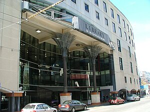
Wellington Central Library
Library building in New Zealand
Distance: Approx. 201 meters
Latitude and longitude: -41.2882,174.7768
Wellington Central Library (Māori: Te Matapihi ki te Ao Nui) is a public library building in the central business district of Wellington, in New Zealand. It is owned by Wellington City Council and is listed as a Category 1 historic place by Heritage New Zealand. The building was opened in 1991 and was a key element of Wellington’s municipal centre, Te Ngākau Civic Square.
Quasi (sculpture)
Sculpture by Ronnie van Hout
Distance: Approx. 235 meters
Latitude and longitude: -41.28841111,174.77719722
Quasi is a sculpture by New Zealand artist Ronnie van Hout currently located on the roof of City Gallery Wellington. The sculpture, van Hout's unsmiling face on the back of a 5-metre hand, has drawn negative remarks, with replies to the initial tweet announcing the installation of the sculpture on the roof of City Gallery Wellington ranging from "kinda creepy" and "really ugly" to "hideous" and "a Lovecraftian nightmare come to life".
Weather in this IP's area
scattered clouds
10 Celsius
9 Celsius
9 Celsius
12 Celsius
999 hPa
70 %
999 hPa
995 hPa
10000 meters
6.69 m/s
350 degree
42 %
06:13:57
18:14:57