155.49.100.216 - IP Lookup: Free IP Address Lookup, Postal Code Lookup, IP Location Lookup, IP ASN, Public IP
Country:
Region:
City:
Location:
Time Zone:
Postal Code:
ISP:
ASN:
language:
User-Agent:
Proxy IP:
Blacklist:
IP information under different IP Channel
ip-api
Country
Region
City
ASN
Time Zone
ISP
Blacklist
Proxy
Latitude
Longitude
Postal
Route
db-ip
Country
Region
City
ASN
Time Zone
ISP
Blacklist
Proxy
Latitude
Longitude
Postal
Route
IPinfo
Country
Region
City
ASN
Time Zone
ISP
Blacklist
Proxy
Latitude
Longitude
Postal
Route
IP2Location
155.49.100.216Country
Region
massachusetts
City
canton
Time Zone
America/New_York
ISP
Language
User-Agent
Latitude
Longitude
Postal
ipdata
Country
Region
City
ASN
Time Zone
ISP
Blacklist
Proxy
Latitude
Longitude
Postal
Route
Popular places and events near this IP address
Massasoit Community College
Public community college in Brockton, Massachusetts, US
Distance: Approx. 2982 meters
Latitude and longitude: 42.18343056,-71.10395278
Massasoit Community College is a public community college in Brockton, Massachusetts. It was founded in 1966 and named for Massasoit, the Great Sachem of the Wampanoag. Massasoit Community College is accredited by the New England Commission of Higher Education.

Blue Hills Regional Technical School
Public school
Distance: Approx. 2758 meters
Latitude and longitude: 42.1814,-71.1053
The Blue Hills Regional Vocational Technical High School is a high school in Canton, Massachusetts. It is in the geographical center of member towns of the Blue Hills Regional School District: Avon, Braintree, Milton, Canton, Norwood, Randolph, Dedham, Westwood, and Holbrook. The school is situated on a 35-acre (140,000 m2) campus that borders the DCR's Blue Hills Reservation, and is within view of Great Blue Hill.

Canton Viaduct
Railroad viaduct in Massachusetts, U.S.
Distance: Approx. 1982 meters
Latitude and longitude: 42.15888889,-71.15388889
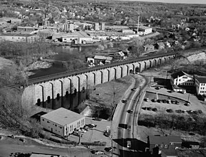
Canton Viaduct is a blind arcade cavity wall in Canton, Massachusetts, built in 1834–35 for the Boston and Providence Railroad. At its completion, it was the longest (615 ft [187 m]) and tallest (70 ft [21 m]) railroad viaduct in the world; today, it is the last surviving viaduct of its kind. It has been in continuous service for 189 years; it now carries high-speed passenger and freight rail service.
Blue Hill Country Club
Distance: Approx. 2954 meters
Latitude and longitude: 42.19333333,-71.13694444
Blue Hill Country Club is a private country club located in Canton, Massachusetts established in 1925. It has hosted professional tournaments on both the PGA Tour and LPGA Tour, including the PGA Championship, a major championship on the PGA Tour. It includes two courses: the 18-hole Championship Course, designed in 1925 by Eugene "Skip" Wogan and the 9-hole Challenger Course, designed in 1961 by Wogan's son Phil.
Canton Junction station
Railway station in Canton, Massachusetts, US
Distance: Approx. 1811 meters
Latitude and longitude: 42.1628,-71.1537
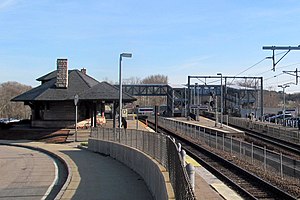
Canton Junction station is an MBTA Commuter Rail station in Canton, Massachusetts. It serves the Providence/Stoughton Line, and is planned for future service on the South Coast Rail line. It is located slightly north of the Canton Viaduct and west of downtown Canton.
Canton Center station
Rail station in Canton, Massachusetts, US
Distance: Approx. 1585 meters
Latitude and longitude: 42.1571,-71.1463
Canton Center is an MBTA Commuter Rail station in Canton, Massachusetts. It serves the Providence/Stoughton Line, including most Stoughton Branch service except for evening inbound trains. The station has 1 side platform on the south side of the track west of Washington Street; the platform has a mini-high section for accessibility.
1956 PGA Championship
Golf tournament
Distance: Approx. 2587 meters
Latitude and longitude: 42.19,-71.137
The 1956 PGA Championship was the 38th edition of the professional golf competition, held at Blue Hill Country Club in Canton, Massachusetts, a suburb southwest of Boston. Jack Burke Jr. won his second major championship of 1956, a 3 and 2 victory over Ted Kroll; Burke had won the Masters in April.

Signal Hill (Canton, Massachusetts)
Protected natural area in the U.S. state of Massachusetts
Distance: Approx. 2966 meters
Latitude and longitude: 42.185,-71.159
Signal Hill is a 150-acre (61 ha) open space preserve located in Canton, in the U.S. state of Massachusetts; it is centered on a 188-foot (57 m) rocky knoll by the same name. The property, acquired in 2005 by the land conservation non-profit organization The Trustees of Reservations, offers frontage on the Neponset River and views of Great Blue Hill and Downtown Boston from open ledges. The Signal Hill preserve also includes wetlands, open fields, and a car-top boating access point.

Canton River (United States)
River in Massachusetts, United States
Distance: Approx. 2733 meters
Latitude and longitude: 42.1576,-71.1631
The Canton River is a river passing through Canton, Massachusetts. It flows into the Neponset River, connecting Bolivar Pond and Forge Pond. It traces down Washington and Neponset Streets (flowing under the Canton Viaduct), and continues down Walpole Street.

Canton Corner Historic District
Historic district in Massachusetts, United States
Distance: Approx. 823 meters
Latitude and longitude: 42.17388889,-71.13611111
The Canton Corner Historic District is a historic district encompassing the historic town center of Canton, Massachusetts. Centered on the junction of Pleasant and Washington Streets, it includes more than 25 properties and 170 acres (69 ha), whose architectural history spans 250 years of occupation and include the town's major civic buildings. The district was added to the National Register of Historic Places on September 9, 2009.

Canton High School (Massachusetts)
Public school in Canton, Massachusetts, United States
Distance: Approx. 1167 meters
Latitude and longitude: 42.1625,-71.145278
Canton High School (CHS) is a secondary school in Canton, Massachusetts, United States.

Springdale station (Massachusetts)
Distance: Approx. 2129 meters
Latitude and longitude: 42.148046,-71.129031
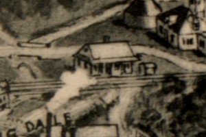
Springdale station was a New York, New Haven and Hartford Railroad station in the village of Springdale in Canton, Massachusetts. It was located on the Stoughton Branch. The station was built by the Old Colony Railroad at a cost $1,200.
Weather in this IP's area
moderate rain
3 Celsius
0 Celsius
3 Celsius
3 Celsius
1004 hPa
96 %
1004 hPa
999 hPa
613 meters
2.82 m/s
6.44 m/s
56 degree
100 %

