Country:
Region:
City:
Latitude and Longitude:
Time Zone:
Postal Code:
IP information under different IP Channel
ip-api
Country
Region
City
ASN
Time Zone
ISP
Blacklist
Proxy
Latitude
Longitude
Postal
Route
IPinfo
Country
Region
City
ASN
Time Zone
ISP
Blacklist
Proxy
Latitude
Longitude
Postal
Route
MaxMind
Country
Region
City
ASN
Time Zone
ISP
Blacklist
Proxy
Latitude
Longitude
Postal
Route
Luminati
Country
ASN
Time Zone
America/Chicago
ISP
SWITCH-LTD
Latitude
Longitude
Postal
db-ip
Country
Region
City
ASN
Time Zone
ISP
Blacklist
Proxy
Latitude
Longitude
Postal
Route
ipdata
Country
Region
City
ASN
Time Zone
ISP
Blacklist
Proxy
Latitude
Longitude
Postal
Route
Popular places and events near this IP address

Upton, Massachusetts
Town in Massachusetts, United States
Distance: Approx. 5266 meters
Latitude and longitude: 42.17444444,-71.60277778
Upton is a town in Worcester County, Massachusetts, United States. It was first settled in 1728. The population was given as exactly 8,000 at the 2020 census.

Hopkinton, Massachusetts
Town in Massachusetts, United States
Distance: Approx. 4213 meters
Latitude and longitude: 42.22861111,-71.52305556
Hopkinton is a town in Middlesex County, Massachusetts, United States, 25 miles (40 km) west of Boston. The town is best known as the starting point of the Boston Marathon, held annually on Patriots' Day each April, and as the headquarters for the Dell EMC corporation. At the 2020 census, the town had a population of 18,758.

Azariah Newton House
Historic house in Massachusetts, United States
Distance: Approx. 3122 meters
Latitude and longitude: 42.16722222,-71.53555556
The Azariah Newton House is a historic house at 44 Silver Hill Road in Milford, Massachusetts. It is a 1+1⁄2-story wood-frame Cape style house, with a side-gable roof, clapboard siding, and large central chimney. The interior has retained substantial interior finishing, including floors, fireplaces, and room layout.

Upton Town Hall
United States historic place
Distance: Approx. 4522 meters
Latitude and longitude: 42.17388889,-71.59222222
Upton Town Hall is a historic town hall at 1 Main Street in Upton, Massachusetts, United States. The Late Gothic Revival/Queen Anne brick building was built in 1884 to a design by Worcester architects E. Boyden & Son. It features irregular massing typical of Queen Anne style, with a variety of gables and roof lines.

Hopkinton Supply Co. Building
United States historic place
Distance: Approx. 4284 meters
Latitude and longitude: 42.22861111,-71.52111111
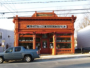
The Hopkinton Supply Co. Building is a historic commercial building at 26-28 Main Street in Hopkinton, Massachusetts. The single-story pressed metal building was built in 1906, and is a locally unusual example of a mail-order commercial storefront.
Milford High School (Massachusetts)
Public high school in Milford, Worcester County, Massachusetts, United States
Distance: Approx. 5034 meters
Latitude and longitude: 42.15,-71.53333333
Milford High School (MHS) is the secondary school for the district of Milford, Massachusetts, Milford Public Schools. Its principal is Joshua Otlin and William Chaplin (House A) is associate principal. Jessica Zaleski (House A) and Richard Piergustavo (House B) are assistant principals.
Hopkinton High School (Massachusetts)
Public school in the United States
Distance: Approx. 3495 meters
Latitude and longitude: 42.21953889,-71.51950833
Hopkinton High School is a public, co-educational secondary school located in Hopkinton, Massachusetts. In 2011 and 2015 it ranked in the top 100 schools on Newsweek magazine's list of "America's Best High Schools".

Hopkinton (CDP), Massachusetts
Census-designated place in Massachusetts, United States
Distance: Approx. 4225 meters
Latitude and longitude: 42.22833333,-71.52194444
Hopkinton is a census-designated place (CDP) comprising the central village in the town of Hopkinton, Middlesex County, Massachusetts, United States. The population of the CDP was 2,651 at the 2020 census, out of 18,758 in the entire town.

M.H. Merriam and Company
United States historic place
Distance: Approx. 4284 meters
Latitude and longitude: 42.22861111,-71.52111111
The M.H. Merriam and Company is a historic factory building at 7-9 Oakland Street in Lexington, Massachusetts. The single story wood-frame factory building, built in 1882, is located just outside Lexington's central business district. It is unusual in part because Lexington was at the time a primarily rural town, and is important for its association with Matthew H. Merriam, a businessman, industrialist, banker, and civic leader, whose principal business was leatherwork associated with the manufacture of footwear.

Upton State Forest
Protected area in Massachusetts, United States
Distance: Approx. 5461 meters
Latitude and longitude: 42.20916667,-71.60805556
Upton State Forest is a publicly owned forest with recreational features primarily located in the town of Upton, Massachusetts, with smaller sections in the towns of Hopkinton and Westborough. The state forest encompasses nearly 2,800 acres (1,100 ha) of publicly accessible lands and includes the last remaining Civilian Conservation Corps (CCC) camp in Massachusetts, built in Rustic style. The CCC campground was listed on the National Register of Historic Places in 2014.

Whitehall State Park
Massachusetts state park
Distance: Approx. 4973 meters
Latitude and longitude: 42.22916667,-71.58277778
Whitehall State Park is a Massachusetts state park located in the town of Hopkinton and managed by the Department of Conservation and Recreation. The park was created in 1947 when the Whitehall Reservoir was removed from service as a water source for the Greater Boston area.

Upton Center Historic District
Historic district in Massachusetts, United States
Distance: Approx. 5313 meters
Latitude and longitude: 42.17388889,-71.60305556
The Upton Center Historic District encompasses the historic center of the town of Upton, Massachusetts. Its main focus is Central Square, located near a complex series of junctions involving Main, North Main, Milford, Grove, Church, and Warren Streets. This area, the site of the town green, was where its first meetinghouse was built, and is still the center of civic and religious life in the community.
Weather in this IP's area
clear sky
21 Celsius
20 Celsius
20 Celsius
23 Celsius
1019 hPa
46 %
1019 hPa
1002 hPa
10000 meters
0.89 m/s
3.58 m/s
51 degree
1 %
06:47:54
18:20:44