154.92.9.160 - IP Lookup: Free IP Address Lookup, Postal Code Lookup, IP Location Lookup, IP ASN, Public IP
Country:
Region:
City:
Location:
Time Zone:
Postal Code:
ISP:
ASN:
language:
User-Agent:
Proxy IP:
Blacklist:
IP information under different IP Channel
ip-api
Country
Region
City
ASN
Time Zone
ISP
Blacklist
Proxy
Latitude
Longitude
Postal
Route
db-ip
Country
Region
City
ASN
Time Zone
ISP
Blacklist
Proxy
Latitude
Longitude
Postal
Route
IPinfo
Country
Region
City
ASN
Time Zone
ISP
Blacklist
Proxy
Latitude
Longitude
Postal
Route
IP2Location
154.92.9.160Country
Region
lefkosia
City
nicosia
Time Zone
Asia/Nicosia
ISP
Language
User-Agent
Latitude
Longitude
Postal
ipdata
Country
Region
City
ASN
Time Zone
ISP
Blacklist
Proxy
Latitude
Longitude
Postal
Route
Popular places and events near this IP address

Ledra
Distance: Approx. 595 meters
Latitude and longitude: 35.1625,33.3625
Ledra (Greek: Λήδρα), also spelt Ledrae, was an ancient city-kingdom located in the centre of Cyprus where the capital city of Nicosia is today. Ledra was established in 1050 BC. It became a city-kingdom by the seventh century BC. At times, it had been subject to Assyrian rule. Ledra was one of ten Cypriot kingdoms listed on the prism (many-sided tablet) of the Assyrian king Esarhaddon (680–669 BC).

Leventis Municipal Museum of Nicosia
Distance: Approx. 637 meters
Latitude and longitude: 35.1706,33.3617
The Leventis Municipal Museum of Nicosia (Greek: Λεβέντιο Μουσείο, Turkish: Leventis Müzesi) in Nicosia, Cyprus, is home to an extensive collection of Cypriot works include archaeological artifacts, costumes, photographs, medieval pottery, maps and engravings, jewels, and furniture.

Nicosia aqueduct
Bridge in Nicosia, Cyprus
Distance: Approx. 655 meters
Latitude and longitude: 35.17194444,33.36972222
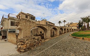
Nicosia old aqueduct is located in Nicosia, the capital of Cyprus and is the oldest aqueduct in Cyprus. It is located close to the Liberty Monument in Nicosia.

Tower 25
High-rise in Nicosia, Cyprus
Distance: Approx. 607 meters
Latitude and longitude: 35.1686,33.3605
Tower 25, also known as The White Walls, is a high-rise building located in central Nicosia, the capital of Cyprus. Designed by architect Jean Nouvel, it gained recognition as one of Nicosia's notable landmarks due to its distinctive design and central location. Standing at a height of 62 meters, Tower 25 ranks as the eleventh-tallest building in Cyprus.

Hadjigeorgakis Kornesios Mansion
Architecture of the last century of Ottoman rule, Nicosia, Cyprus (built 1779)
Distance: Approx. 595 meters
Latitude and longitude: 35.171938,33.3669
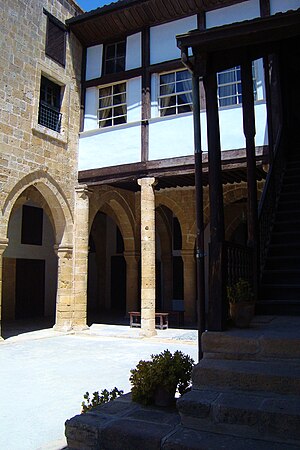
The Hadjigeorgakis Kornesios Mansion is situated near the Archbishopric, in the neighbourhood of Saint Antonios in Nicosia, Cyprus, where the wealthy notables of the Greek community traditionally used to live.
Ayios Antonios, Nicosia
Place in Nicosia District, Cyprus
Distance: Approx. 572 meters
Latitude and longitude: 35.17166667,33.36777778
Ayios Antonios (Greek: Άγιος Αντώνιος) is a Neighbourhood, Quarter, Mahalla or Parish of Nicosia, Cyprus and the parish church thereof. At the last Census (2011) it had a population of 5,801, an increase from a population of 5,233 in 2001. It covers 97 streets in the south-east corner of the municipal area of Nicosia.
Ayios Savvas, Nicosia
Place in Nicosia District, Cyprus
Distance: Approx. 615 meters
Latitude and longitude: 35.17138889,33.36333333
Ayios Savvas is a neighbourhood, quarter, mahalla or parish of Nicosia, Cyprus and the parish church thereof. At the last census (2011) it had a population of 581, an increase from a population of 523 in 2001. It covers 25 streets in the south of Nicosia within the walls.

Bayraktar Mosque
Mosque in Nicosia, Cyprus
Distance: Approx. 299 meters
Latitude and longitude: 35.16908,33.36543
Bayraktar Mosque (Turkish: Bayraktar Camisi, Greek: Τέμενος Μπαϊρακτάρ Témenos Mpairaktár) is a mosque in Nicosia, Cyprus, currently placed in the southern sector of the city administered by the Republic of Cyprus.

Ömeriye Mosque
Mosque in Nicosia, Cyprus
Distance: Approx. 602 meters
Latitude and longitude: 35.1719,33.3654
Ömeriye Mosque (Greek: Τέμενος Ομεριέ Temenos Omerié, Turkish: Ömeriye Camii), is a mosque in the walled city of Nicosia on the island of Cyprus, located in the south section of Nicosia. Following the Turkish invasion of Cyprus, the mosque gained significance as one of the most important sites of Muslim worship in the non-Muslim section of the island and the city. Currently the mosque is functioning and open for both worshipers and visitors.

St. John's Cathedral, Nicosia
Main church of the Church of Cyprus
Distance: Approx. 602 meters
Latitude and longitude: 35.172,33.367
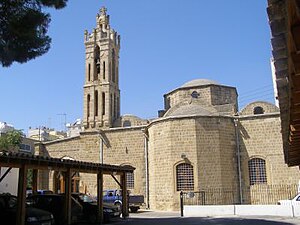
The Cathedral of St. John the Theologian (Greek: Καθεδρικός Ναός Αγίου Ιωάννη) is the main church of the Church of Cyprus. It is located in Nicosia, the capital city of Cyprus.

Liberty Monument (Nicosia)
Distance: Approx. 642 meters
Latitude and longitude: 35.17155556,33.37030556
The Liberty Monument (Greek: Μνημείο Ελευθερίας, "Mnēmeío Eleftherías" or "Eleftheria Monument") is a monument in the city of Nicosia in Cyprus. The Liberty Monument was erected in 1973 to honor the anti-British EOKA fighters of the Cyprus Emergency of 1955–1959. It is located at the Podocattaro Bastion of the Venetian walls.

Archangel Michael Trypiotis Church
Cultural property in Nicosia, Cyprus
Distance: Approx. 639 meters
Latitude and longitude: 35.171312,33.362687
The Archangel Michael Trypiotis Church (Greek: Ιερός Ναός Αρχαγγέλου Μιχαήλ Τρυπιώτου) is a Greek Orthodox church in the old town of Nicosia, Cyprus. Although incorporating earlier material, according to the inscription beside the south porch the church is dated to 1695 and it was built at the expense of the Priest Iakovos and Christian parishioners. Important features of the church are the beautiful 18th century iconostasis that was carved by Taliadoros and the icon of Archangel Michael, which dates to 1634.
Weather in this IP's area
broken clouds
6 Celsius
4 Celsius
6 Celsius
6 Celsius
1021 hPa
93 %
1021 hPa
987 hPa
10000 meters
2.06 m/s
240 degree
75 %
