Country:
Region:
City:
Latitude and Longitude:
Time Zone:
Postal Code:
IP information under different IP Channel
ip-api
Country
Region
City
ASN
Time Zone
ISP
Blacklist
Proxy
Latitude
Longitude
Postal
Route
Luminati
Country
Region
nc
City
kimberley
ASN
Time Zone
Africa/Johannesburg
ISP
ICTGLOBE
Latitude
Longitude
Postal
IPinfo
Country
Region
City
ASN
Time Zone
ISP
Blacklist
Proxy
Latitude
Longitude
Postal
Route
db-ip
Country
Region
City
ASN
Time Zone
ISP
Blacklist
Proxy
Latitude
Longitude
Postal
Route
ipdata
Country
Region
City
ASN
Time Zone
ISP
Blacklist
Proxy
Latitude
Longitude
Postal
Route
Popular places and events near this IP address

Kimberley, Northern Cape
Capital of the Northern Cape, South Africa
Distance: Approx. 607 meters
Latitude and longitude: -28.73833333,24.76388889
Kimberley is the capital and largest city of the Northern Cape province of South Africa. It is located approximately 110 km east of the confluence of the Vaal and Orange Rivers. The city has considerable historical significance due to its diamond mining past and the siege during the Second Anglo-Boer war.

Big Hole
Open-pit and underground mine in Kimberley, South Africa
Distance: Approx. 940 meters
Latitude and longitude: -28.73888889,24.75888889
The Kimberley Mine or Tim Kuilmine (Afrikaans: Groot Gat) is an open-pit and underground mine in Kimberley, South Africa, and claimed to be the deepest hole excavated by hand, although this claim is disputed by Jagersfontein.

Siege of Kimberley
1899–1900 battle of the Second Boer War
Distance: Approx. 607 meters
Latitude and longitude: -28.73833333,24.76388889
The siege of Kimberley took place during the Second Boer War at Kimberley, Cape Colony (present-day South Africa), when Boer forces from the Orange Free State and the Transvaal besieged the diamond mining town. The Boers moved quickly to try to capture the area when war broke out between the British and the two Boer republics in October 1899. The town was ill-prepared, but the defenders organised an energetic and effective improvised defence that was able to prevent it from being taken.
St Cyprian's Grammar School, Kimberley
Private/independent school in Kimberley, South Africa
Distance: Approx. 1078 meters
Latitude and longitude: -28.74222222,24.77
St. Cyprian's Grammar School in Kimberley, South Africa, is a co-educational English-medium independent school for Grades R and 1–12, attached to St Cyprian's Cathedral (Anglican Diocese of Kimberley and Kuruman, Anglican Church of Southern Africa). In its present form it opened to 83 students on 21 January 2009.

St Cyprian's Cathedral, Kimberley
Church in Kimberley, South Africa
Distance: Approx. 1127 meters
Latitude and longitude: -28.7425,24.77055556
The Cathedral Church of St Cyprian the Martyr, Kimberley, is the seat of the Bishop of the Kimberley and Kuruman, Anglican Church of Southern Africa. The building was dedicated in 1908, becoming a Cathedral when the Synod of Bishops mandated formation of the new Diocese of Kimberley and Kuruman in October 1911. The first Bishop, the Rt Revd Wilfrid Gore Browne, was enthroned there on 30 June 1912.
Eureka Diamond
Distance: Approx. 1235 meters
Latitude and longitude: -28.738237,24.754727
The Eureka Diamond was the first diamond discovered in South Africa. It originally weighed 21.25 carats (4.250 g), and was later cut to a 10.73-carat (2.146 g) cushion-shaped brilliant, which is currently on display at the Mine Museum in Kimberley. The discovery of diamonds in South Africa led to the Kimberley Diamond Rush, and marked the beginning of the Mineral Revolution.
William Humphreys Art Gallery
Distance: Approx. 1193 meters
Latitude and longitude: -28.74361111,24.76888889
The William Humphreys Art Gallery, in Kimberley, South Africa, was opened in 1952 and named after its principal benefactor, William Benbow Humphreys (1889–1965).
Kimberley railway station (South Africa)
Railway station in South Africa
Distance: Approx. 431 meters
Latitude and longitude: -28.73527778,24.76972222
Kimberley railway station is the central railway station of the city of Kimberley, in the Northern Cape province of South Africa. Because Kimberley is the junction of the main Cape Town–Johannesburg main line with another line from Bloemfontein, it is served by several routes of the Shosholoza Meyl inter-city service. Kimberley railway station is also used by the luxury tourist-oriented Blue Train and the private train holiday company Rovos Rail.

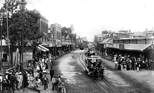
Trams in Kimberley, Northern Cape
Former public transport system in Kimberley, South Africa
Distance: Approx. 1368 meters
Latitude and longitude: -28.74444444,24.77166667
The Kimberley tramway network formed part of the public transport system in Kimberley, Northern Cape, South Africa, for roughly 60 years until the late 1940s. Operation started with horse-drawn trams, on 21 June 1887. Mules replaced the horses in the early 1890s.: 8 For a few years starting in 1900 tram sets hauled by steam tram engines were also operated on some lines.

Sol Plaatje University
Public university in Kimberly, South Africa
Distance: Approx. 1337 meters
Latitude and longitude: -28.74511818,24.76427601
Sol Plaatje University is a public university located in Kimberley, South Africa. Established in 2014, it is the first and only university located in the Northern Cape province.
Northern Cape Heritage Resources Authority
Distance: Approx. 266 meters
Latitude and longitude: -28.73555556,24.76555556
The Northern Cape Heritage Resources Authority, previously called Ngwao Boswa jwa Kapa Bokone (seTswana for 'Heritage Northern Cape'), and commonly known as 'Boswa', is a provincial heritage resources authority established in 2003 by the MEC for Sport, Arts and Culture in the Northern Cape Province of South Africa, and reconstituted in terms of the Northern Cape Heritage Resources Authority Act, 2013. It is an institution set up under the terms of the National Heritage Resources Act. It is mandated to care for that part of South Africa's national estate that is of provincial and local significance in the Northern Cape.
De Beers Stadium
Cricket stadium in South Africa
Distance: Approx. 1283 meters
Latitude and longitude: -28.7267,24.77685
The De Beers Stadium in Kimberley, Northern Cape, South Africa was the home ground of the Griqualand West (now called Northern Cape) cricket team from 1927 to 1973. It staged a total of 88 first-class matches, in all of which Griqualand West was the home team. Their opponents were usually rival teams in the Currie Cup and the venue also hosted international touring teams including Marylebone Cricket Club (MCC), the Australians and the New Zealanders.
Weather in this IP's area
scattered clouds
21 Celsius
20 Celsius
21 Celsius
21 Celsius
1013 hPa
47 %
1013 hPa
881 hPa
10000 meters
4.63 m/s
20 degree
42 %
05:19:10
18:52:14
