154.57.242.97 - IP Lookup: Free IP Address Lookup, Postal Code Lookup, IP Location Lookup, IP ASN, Public IP
Country:
 Great Britain
Region:
City:
Location:
Time Zone:
Postal Code:
ISP:
ASN:
language:
User-Agent:
Proxy IP:
Blacklist:
IP information under different IP Channel
ip-api
Country
Region
City
ASN
Time Zone
ISP
Blacklist
Proxy
Latitude
Longitude
Postal
Route
db-ip
Country
Region
City
ASN
Time Zone
ISP
Blacklist
Proxy
Latitude
Longitude
Postal
Route
IPinfo
Country
Region
City
ASN
Time Zone
ISP
Blacklist
Proxy
Latitude
Longitude
Postal
Route
IP2Location
154.57.242.97Country
gbRegion
england
City
bedford
Time Zone
Europe/London
ISP
Language
User-Agent
Latitude
Longitude
Postal
ipdata
Country
Region
City
ASN
Time Zone
ISP
Blacklist
Proxy
Latitude
Longitude
Postal
Route
Popular places and events near this IP address

Mid Bedfordshire District
Local government district in England
Distance: Approx. 182 meters
Latitude and longitude: 52.13583333,-0.46805556
Mid Bedfordshire was a local government district in Bedfordshire, England, from 1974 to 2009.

Bedford Castle
Medieval castle in Bedford, England
Distance: Approx. 130 meters
Latitude and longitude: 52.1347,-0.4644
Bedford Castle was a large medieval castle in Bedford, England. Built after 1100 by Henry I, the castle played a prominent part in both the civil war of the Anarchy and the First Barons' War. The castle was significantly extended in stone, although the final plan of the castle remains uncertain.

Bedford Corn Exchange
Municipal building in Bedford, England
Distance: Approx. 173 meters
Latitude and longitude: 52.136,-0.4674
The Corn Exchange is an events and concert venue located on St Paul's Square in the Castle area of Bedford, Bedfordshire, England. The structure, which was commissioned as a corn exchange, is a Grade II listed building.
Bedford College, Bedford
Further education school in Bedford, Bedfordshire, England
Distance: Approx. 174 meters
Latitude and longitude: 52.13315,-0.46726
Bedford College is a further education college located in Bedford, Bedfordshire, England. It is the principal further education provider in the Borough of Bedford.
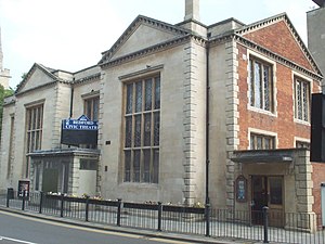
Bedford Civic Theatre
Distance: Approx. 196 meters
Latitude and longitude: 52.13466,-0.46917
The Bedford Civic Theatre was a theatre located on Horne Lane in the town centre of Bedford, Bedfordshire, England. The theatre operated from 1952 to its closure in 2012. The former theatre building is now used as a Council Customer Service Centre.

St Paul's Church, Bedford
Church in England
Distance: Approx. 95 meters
Latitude and longitude: 52.1354,-0.4668
St Paul's Church is a Church of England parish church located on St Paul's Square in Bedford, Bedfordshire, England. Formerly a medieval collegiate church, the large building of cathedral proportions with its later additions and iconic spire dominates the town. St Paul's is the largest Anglican church in Bedfordshire, and the church exercises a ministry of welcome to thousands of visitors and pilgrims from far and wide each year.

Bedford Rowing Club
British rowing club
Distance: Approx. 115 meters
Latitude and longitude: 52.13408,-0.464844
Bedford Rowing Club is an amateur rowing club in Bedford, United Kingdom founded in 1886.
Bedford Abbey
Distance: Approx. 117 meters
Latitude and longitude: 52.1354,-0.4674
Bedford Abbey was a short-lived Benedictine monastery, recorded in 10th-century England. Bedford Priory, perhaps representing the same institution two centuries later, was an Augustinian priory that within two decades of its foundation moved to nearby Newnham. Bedford Abbey existed in the 10th-century, staffed with Benedictine monks when Oscytel, Archbishop of York, died in 971.: 30 : 147 The archbishop was buried in the abbey, after his body was taken there by its abbot, Thurcytel (who later moved to Crowland Abbey).: 30 : 147, 420 Thurcytel is the only known abbot of the monastery.: 30 Its history after this is obscure, and may have evolved into St Paul's Church in Bedford, which became an Augustinian priory c.
The Bedford Sixth Form
UK school providing GCSE and A-level qualifications
Distance: Approx. 174 meters
Latitude and longitude: 52.13315,-0.46726
The Bedford Sixth Form (BSF) is a state sixth form located in the centre of Bedford, Bedfordshire, England. It is the only institution in Bedford solely dedicated to sixth form choices and, unlike most other sixth forms in England, it is not part of a secondary school. The institution offers a range of GCSEs, A-Levels and Technical Diplomas to 16- to 18-year-olds.

Statue of John Howard, Bedford
Distance: Approx. 98 meters
Latitude and longitude: 52.13548,-0.46645
The statue of John Howard, in St Pauls's Square, Bedford, is a bronze of John Howard, erected in 1890, the centenary of Howard's death. The statue is "clothed ... in the travelling dress of the time to denote he was a great traveller." The sculptor was Alfred Gilbert.

Shire Hall, Bedford
County building in Bedford, Bedfordshire, England
Distance: Approx. 76 meters
Latitude and longitude: 52.135,-0.4672
The Shire Hall is a municipal building in St Paul's Square, Bedford, Bedfordshire. The shire hall, which was the headquarters of Bedfordshire County Council from 1888 to 1969, is a Grade II* listed building.

Old Town Hall, Bedford
Municipal building in Bedford, Bedfordshire, England
Distance: Approx. 163 meters
Latitude and longitude: 52.1353,-0.4684
The Old Town Hall is a municipal building in St Paul's Square in Bedford, Bedfordshire, England. The building, which was the headquarters of Bedford Borough Council from 1892 to 2009, is a Grade II listed building.
Weather in this IP's area
overcast clouds
3 Celsius
3 Celsius
2 Celsius
3 Celsius
1019 hPa
52 %
1019 hPa
1010 hPa
36 meters
0.45 m/s
0.89 m/s
34 degree
100 %