Country:
Region:
City:
Latitude and Longitude:
Time Zone:
Postal Code:
IP information under different IP Channel
ip-api
Country
Region
City
ASN
Time Zone
ISP
Blacklist
Proxy
Latitude
Longitude
Postal
Route
Luminati
Country
Region
m
City
metamorfosi
ASN
Time Zone
Europe/Athens
ISP
Novelcom E.e.
Latitude
Longitude
Postal
IPinfo
Country
Region
City
ASN
Time Zone
ISP
Blacklist
Proxy
Latitude
Longitude
Postal
Route
db-ip
Country
Region
City
ASN
Time Zone
ISP
Blacklist
Proxy
Latitude
Longitude
Postal
Route
ipdata
Country
Region
City
ASN
Time Zone
ISP
Blacklist
Proxy
Latitude
Longitude
Postal
Route
Popular places and events near this IP address

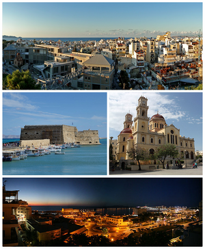
Heraklion
City in Crete, Greece
Distance: Approx. 5498 meters
Latitude and longitude: 35.34027778,25.13444444
Heraklion or Herakleion ( hih-RAK-lee-ən; Greek: Ηράκλειο, Irákleio, pronounced [iˈrakli.o]), sometimes Iraklion, is the largest city and the administrative capital of the island of Crete and capital of Heraklion regional unit. It is the fourth largest city in Greece with a municipal population of 179,302 (2021) and 211,370 in its wider metropolitan area, according to the 2011 census. The greater area of Heraklion has been continuously inhabited since at least 7000 BCE, making it one of the oldest inhabited regions in Europe.

Pankritio Stadium
Building in Heraklion, Crete Region, Greece
Distance: Approx. 4761 meters
Latitude and longitude: 35.33666667,25.10611111
The Pankritio Stadium (Greek: Παγκρήτιο Στάδιο, Pagkritio Stadio, literally: Pancretan Stadium) is a multi-purpose sports stadium located in Heraklion on the island of Crete. It was completed on 31 December 2003, and officially opened on 11 August 2004. As one of the most modern sports venues in Greece at the time, it was used as one of the football venues to host matches of the 2004 Summer Olympic football tournament.

Historical Museum of Crete
Distance: Approx. 5180 meters
Latitude and longitude: 35.34180556,25.13116667
The Historical Museum of Crete is a museum in Heraklion, Crete. It was founded by the Society of Cretan Historical Studies in 1953 and was originally housed in the former home of Minos Kalokairinos. The museum has since been expanded with a modern wing.

Lions Square
Distance: Approx. 5526 meters
Latitude and longitude: 35.3391,25.1331
Eleftheriou Venizelou Square (Greek: Πλατεία Ελευθερίου Βενιζέλου) is a square in the city of Heraklion in Crete, named after the Cretan statesman Eleftherios Venizelos. It dates back to the Venetian era and is more commonly known as Lions Square (Greek: Πλατεία Λεόντων) or Leonton Square (genitive), after the Venetian-era Morosini Fountain (popularly called "τα Λιοντάρια", "The Lions") in its midst, which features four lions supporting the main basin.

Theodoros Vardinogiannis Stadium
Distance: Approx. 4821 meters
Latitude and longitude: 35.33805556,25.11472222
Theodoros Vardinogiannis Stadium (Greek: Γήπεδο Θεόδωρος Βαρδινογιάννης), commonly referred to by its nickname, Yedi Kule, is a football stadium located in Heraklion, Crete, Greece. It was built in 1951 as the home ground of OFI Crete. The nickname "Yedi Kule" refers to the historical Heptapyrgion fortress (commonly known as "Yedi Kule" in Ottoman Turkish), a Byzantine and Ottoman-era stronghold located in Thessaloniki.

Natural History Museum of Crete
Natural history museum in Sof. Venizelou Avenue, Heraklion
Distance: Approx. 4929 meters
Latitude and longitude: 35.3419,25.1266
The Natural History Museum of Crete (NHMC) (Greek: Μουσείο Φυσικής Ιστορίας Κρήτης, ΜΦΙΚ) in Heraklion, Crete is a natural history museum that operates under the auspices of the University of Crete. Its aim is the study, protection and promotion of the diverse flora and fauna of the Eastern Mediterranean region. The museum is based in a restored industrial building that used to house an electricity power plant.

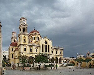
Agios Minas Cathedral
Greek cathedral in Heraklion, Crete, Greece
Distance: Approx. 5550 meters
Latitude and longitude: 35.3375,25.13083333
The Agios Minas Cathedral (Greek: ῾Ιερός Μητροπολιτικός Ναός ῾Αγίου Μηνᾶ) is a Greek Orthodox Cathedral in Heraklion, Greece, serving as the seat of the Archbishop of Crete. Ιt is dedicated to Saint Menas the martyr and wonderworker (285-309 A.D.), who is the patron saint of Heraklion.
Lido Indoor Hall
Distance: Approx. 4841 meters
Latitude and longitude: 35.33572194,25.10452139
The Lido Indoor Hall, or simply, the Lido Hall, is a multi-purpose indoor arena that is located in the city of Heraklion, on the island of Crete, in Greece. It is named after the district where it's located, called Lido (Greek: Λίντο). The arena has been used to host a variety of sports events, such as volleyball, boxing, kickboxing, wrestling and Mixed martial arts, but its primary use is hosting basketball games.
Heracleium
Ancient harbor town of Crete in Greece
Distance: Approx. 5391 meters
Latitude and longitude: 35.340702,25.133221
Heracleium or Herakleion (Ancient Greek: Ἡράκλειον), also known as Heracleia or Herakleia (Ἡράκλεια), was a town in ancient Crete, which Strabo calls the port of Knossos, and was situated, according to the anonymous coast-describer (Stadiasmus), at a distance of 20 stadia from that city. Stephanus of Byzantium simply mentions the town as the 17th of the 23 Heracleias he enumerates. Although the ecclesiastical notices make no mention of this place as a bishop's see, yet there is found among the subscriptions to the proceedings of the Second Council of Nicaea, along with other Cretan prelates, Theodoros, bishop of Heracleopolis.

Fraskia Bay
Kingdom of Candia
Distance: Approx. 4982 meters
Latitude and longitude: 35.388,25.0427
Fraskia Bay, also transliterated as Fraschia (Greek: όρμος Φρασκιών, Φρασκιά), is a small bay on the north coast of Crete in Greece. It is located 10 km northwest of Heraklion near the villages of Rodia and Palaiokastro. Fraskia bay got its name from the word Fraski (Greek: Φρασκί), which is a type of baked clay beehive; the hills next to the shore are abundant in thyme and hence well-suited to apiculture.
Giophyros River
River in Crete
Distance: Approx. 4504 meters
Latitude and longitude: 35.341,25.1144
The Giophyros or Platyperama is a river near Iraklion, Crete. Its ancient name was the Triton.

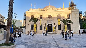
Saint Titus Cathedral
Cathedral of Heraklion, Crete
Distance: Approx. 5528 meters
Latitude and longitude: 35.3401,25.1347
The Cathedral of Saint Titus (Greek: Καθεδρικός Ναός Αγίου Τίτου) also known as Hagios Titos, is an Orthodox church in the city of Heraklion, Crete, dedicated to Saint Titus. The current church was built in 1869 as the Yeni Cami ("New Mosque") after the previous building was destroyed by the earthquake of 1856. In 1925 it was converted to Christian worship.
Weather in this IP's area
scattered clouds
19 Celsius
19 Celsius
19 Celsius
20 Celsius
1021 hPa
70 %
1021 hPa
1021 hPa
10000 meters
6.69 m/s
310 degree
40 %
06:43:15
17:23:01