Country:
 Great Britain
Region:
City:
Latitude and Longitude:
Time Zone:
Postal Code:
IP information under different IP Channel
ip-api
Country
Region
City
ASN
Time Zone
ISP
Blacklist
Proxy
Latitude
Longitude
Postal
Route
IPinfo
Country
Region
City
ASN
Time Zone
ISP
Blacklist
Proxy
Latitude
Longitude
Postal
Route
MaxMind
Country
Region
City
ASN
Time Zone
ISP
Blacklist
Proxy
Latitude
Longitude
Postal
Route
Luminati
Country
GBRegion
eng
City
london
ASN
Time Zone
Europe/London
ISP
Hostline, Uab
Latitude
Longitude
Postal
db-ip
Country
Region
City
ASN
Time Zone
ISP
Blacklist
Proxy
Latitude
Longitude
Postal
Route
ipdata
Country
Region
City
ASN
Time Zone
ISP
Blacklist
Proxy
Latitude
Longitude
Postal
Route
Popular places and events near this IP address
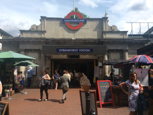
Embankment tube station
London Underground station
Distance: Approx. 172 meters
Latitude and longitude: 51.507,-0.122
Embankment is a London Underground station in the City of Westminster, known by various names during its history. It is served by the Bakerloo, Circle, District and Northern lines. On the Bakerloo line and the Charing Cross branch of the Northern line, the station is between Charing Cross and Waterloo stations.

Victoria Embankment
Road and river-walk along the north bank of the River Thames in London
Distance: Approx. 145 meters
Latitude and longitude: 51.50722222,-0.12166667
Victoria Embankment is part of the Thames Embankment, a road and river-walk along the north bank of the River Thames in London, England. Built in the 1860s, it runs from the Palace of Westminster to Blackfriars Bridge in the City of London, and acts as a major thoroughfare for road traffic between the City of Westminster and the City of London. It is noted for several memorials, such as the Battle of Britain Monument, permanently berthed retired vessels, such as HMS President, and public gardens, including Victoria Embankment Gardens.

Hungerford Bridge and Golden Jubilee Bridges
Bridges in London
Distance: Approx. 146 meters
Latitude and longitude: 51.50611111,-0.12
The Hungerford Bridge crosses the River Thames in London, and lies between Waterloo Bridge and Westminster Bridge. Owned by Network Rail Infrastructure Ltd (who use its official name of Charing Cross Bridge) it is a steel truss railway bridge flanked by two more recent, cable-stayed, pedestrian bridges that share the railway bridge's foundation piers, and which are named the Golden Jubilee Bridges. The north end of the bridge is Charing Cross railway station, and is near Embankment Pier and the Victoria Embankment.

Savoy Pier
Former pier in London, England, UK
Distance: Approx. 151 meters
Latitude and longitude: 51.50875,-0.11940278
The Savoy Pier was a river pier located just to the south of the Savoy Hotel on the river Thames, close to the site of the old Savoy Wharf. The pier was the first central London base of Woods River Cruises Ltd, and was designed by Beckett Rankine in 1998 as a temporary structure. It is an unusual design being restrained by transverse radial arms and longitudinal mooring cables.
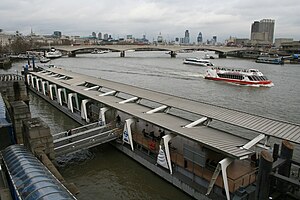
Embankment Pier
Pier on the River Thames near Embankment
Distance: Approx. 111 meters
Latitude and longitude: 51.5073,-0.121193
Embankment Pier is a pier on the River Thames in City of Westminster, London. It is located on the north bank of the river, immediately next to the Hungerford Bridge and directly outside the river entrance to Embankment Underground station. It is also conveniently close to Charing Cross railway station.

Festival Pier
Pier on the River Thames near the South Bank Centre
Distance: Approx. 184 meters
Latitude and longitude: 51.50666667,-0.11722222
Festival Pier is a stop for river boat services on the River Thames, London, UK. It is immediately in front of the Royal Festival Hall and National Film Theatre, and serves the South Bank complex. The pier is owned and operated by London River Services, part of Transport for London.

Imperial Camel Corps Memorial
War memorial in London
Distance: Approx. 189 meters
Latitude and longitude: 51.508499,-0.121671
The Imperial Camel Corps Memorial is an outdoor sculpture commemorating the Imperial Camel Corps, located in Victoria Embankment Gardens, on the Thames Embankment to the east of Charing Cross station, in London, England. The unit of mounted infantry was created in December 1916 from troops that had served in the Gallipoli campaign in the Dardanelles. The memorial was sculpted by Major Cecil Brown, who served in the Corps, with bronze elements cast by A.B. Burton at his Thames Ditton Foundry.

Cheylesmore Memorial
Memorial in London
Distance: Approx. 180 meters
Latitude and longitude: 51.5088,-0.1209
The Cheylesmore Memorial is a Grade II listed outdoor stone memorial dedicated to British Army officer Herbert Eaton, 3rd Baron Cheylesmore, located in the Victoria Embankment Gardens in Westminster, London, England. The memorial was designed by Edwin Lutyens and unveiled in 1930. At the dedication ceremony on 17 July 1930, the memorial was unveiled by Prince Arthur, Duke of Connaught and Strathearn, the third son of Queen Victoria.

Anglo-Belgian Memorial, London
War memorial in London
Distance: Approx. 164 meters
Latitude and longitude: 51.50872222,-0.12062778
The Anglo-Belgian Memorial, also known as the Belgian Gratitude Memorial, Belgian Refugees Memorial, or the Belgian Monument to the British Nation, is a war memorial on Victoria Embankment in London, opposite Cleopatra's Needle. It was a gift from Belgium, as a mark of thanks for assistance given by the UK during the First World War, and in particular for sheltering thousands of Belgian refugees who fled from the war. It is a Grade II* listed building.

Henry Fawcett Memorial
Memorial in London
Distance: Approx. 196 meters
Latitude and longitude: 51.50907,-0.12048
The Henry Fawcett Memorial is a memorial fountain commemorating Henry Fawcett, installed during 1886 at the Victoria Embankment Gardens in London, United Kingdom. Mary Grant created the portrait relief and George Frampton produced the ornamental elements. Basil Champneys was the architect for the memorial.
Lion Brewery Co
Distance: Approx. 192 meters
Latitude and longitude: 51.5062,-0.1176
Lion Brewery Co is a British heritage brewery that was founded in 1836 in Lambeth, London. For over a hundred years, the brewery shipped its heavily-hopped ales to trading posts and ports across the seas. It was one of the main exporters of beer to various parts of the British Empire, until the brewery was damaged by fire and closed in 1931.

Cleopatra's Needle, London
Ancient Egyptian obelisk in London
Distance: Approx. 134 meters
Latitude and longitude: 51.508517,-0.120336
Cleopatra's Needle in London is one of a pair of obelisks, together named Cleopatra's Needles, that were moved from the ruins of the Caesareum of Alexandria, in Egypt, in the 19th century. Inscribed by Thutmose III and later Ramesses II of the Egyptian New Kingdom, the obelisk was moved in 12 BC to Alexandria, where it remained for over 1,800 years. It was presented to the United Kingdom in 1819 by the ruler of Egypt and Sudan Muhammad Ali, as a diplomatic gift.
Weather in this IP's area
scattered clouds
19 Celsius
19 Celsius
17 Celsius
21 Celsius
1004 hPa
77 %
1004 hPa
1002 hPa
10000 meters
2.57 m/s
190 degree
40 %
06:24:52
19:31:37