154.161.108.91 - IP Lookup: Free IP Address Lookup, Postal Code Lookup, IP Location Lookup, IP ASN, Public IP
Country:
Region:
City:
Location:
Time Zone:
Postal Code:
ISP:
ASN:
language:
User-Agent:
Proxy IP:
Blacklist:
IP information under different IP Channel
ip-api
Country
Region
City
ASN
Time Zone
ISP
Blacklist
Proxy
Latitude
Longitude
Postal
Route
db-ip
Country
Region
City
ASN
Time Zone
ISP
Blacklist
Proxy
Latitude
Longitude
Postal
Route
IPinfo
Country
Region
City
ASN
Time Zone
ISP
Blacklist
Proxy
Latitude
Longitude
Postal
Route
IP2Location
154.161.108.91Country
Region
ashanti
City
obuase
Time Zone
Africa/Accra
ISP
Language
User-Agent
Latitude
Longitude
Postal
ipdata
Country
Region
City
ASN
Time Zone
ISP
Blacklist
Proxy
Latitude
Longitude
Postal
Route
Popular places and events near this IP address

Obuasi
Mining Town in Ashanti Region, Ghana
Distance: Approx. 1716 meters
Latitude and longitude: 6.2,-1.68333333
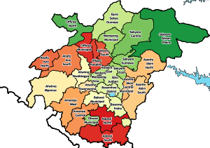
Obuasi is a gold mining town and is the capital of the Obuasi Municipal District in the Ashanti Region of Ghana. It lies in the southern part of the Obuasi Municipal and is located about 39 mi (63 km) from Kumasi. As of 2012, the town has a population of 175,043 people.

Obuasi Municipal Assembly
Municipal District in Ashanti, Ghana
Distance: Approx. 1716 meters
Latitude and longitude: 6.2,-1.68333333
Obuasi Municipal Assembly is one of the forty-three districts in Ashanti Region, Ghana. Originally it was formerly part of the then-larger Adansi West District in 1988, until part of the district was split off to create Obuasi Municipal District on 15 December 2003 (effectively 17 February 2004); whose remaining parts had been absorbed into parts of Adansi North District and Adansi South District respectively. Later, the eastern part of the district was split off to create Obuasi East District on 15 March 2018; thus the remaining part has been retained as Obuasi Municipal Assembly.
Len Clay Stadium
Sports Stadium
Distance: Approx. 1239 meters
Latitude and longitude: 6.20861111,-1.67722222
Len Clay Stadium is a multi-use stadium in Obuasi, Ghana. It was opened on 10 May 1990 and renovated on 17 April 2005 and is home to Ashanti Gold Sporting Club. It has capacity for 20,000 people.
Roman Catholic Diocese of Obuasi
Roman Catholic diocese in Ghana
Distance: Approx. 289 meters
Latitude and longitude: 6.1998,-1.6687
The Roman Catholic Diocese of Obuasi (Latin: Obuasien(sis)) is a diocese located in the city of Obuasi in the ecclesiastical province of Kumasi in Ghana.
Obuasi Gold Mine
Distance: Approx. 6582 meters
Latitude and longitude: 6.14805556,-1.69166667
The Obuasi Gold Mine is an underground gold mine situated near Obuasi, in the Ashanti Region of Ghana. It was at one time one of the world's ten largest gold mines. The mine is in Obuasi Municipal District, 60 kilometres (37 mi) southwest of the regional capital Kumasi.
Akrofuom
Place in Ashanti Region, Ghana
Distance: Approx. 9208 meters
Latitude and longitude: 6.12083333,-1.65361111
Akrofuom is a town on Gyimi River in the Ashanti Region of Ghana. It is the capital of the Akrofuom District. Nana Abena Durowaa I enstooled in December 1999 is the current queenmother of the area.
Dominase
Village in Ashanti Region, Ghana
Distance: Approx. 1716 meters
Latitude and longitude: 6.2,-1.68333333
Dominase is a village in the Bekwai Municipal district, a district in the Ashanti Region of Ghana.

Obuasi East District
District in Ashanti, Ghana
Distance: Approx. 1716 meters
Latitude and longitude: 6.2,-1.68333333
Obuasi East District is one of the forty-three districts in Ashanti Region, Ghana. Originally it was formerly part of the then-larger Obuasi Municipal District on 17 February 2004; until part of the district was split off to create Obuasi East District on 15 March 2018; thus the remaining part has been retained as Obuasi Municipal District. The district assembly is the southern part of Ashanti Region and has Tutuka as its capital town.

Adansi West District
Former District in Ashanti, Ghana
Distance: Approx. 1716 meters
Latitude and longitude: 6.2,-1.68333333
Adansi West District is a former district that was located in Ashanti Region, Ghana. Originally created as an ordinary district assembly in 1988, which was created from the former Adansi District Council. However, on 17 February 2004, it was split out into three parts for three new districts: Obuasi Municipal District (capital: Obuasi), Adansi North District (capital: Fomena) and Adansi South District (capital: New Edubiase).

Akrofuom District
District in Ghana
Distance: Approx. 9617 meters
Latitude and longitude: 6.2875,-1.65361111
Afrokuom District is one of the forty-three districts in Ashanti Region, Ghana. Originally it was formerly part of the then-larger Adansi South District on 17 February 2004, until the western part of the district was split off to create Afrokuom District on 15 March 2018; thus the remaining part has been retained as Adansi South District. The district assembly is located in the southern part of Ashanti Region and has Akrofuom as its capital town.
Akrofuom Senior High Technical School
Mixed second cycle institution in Akrofuom, Ghana
Distance: Approx. 8611 meters
Latitude and longitude: 6.12638889,-1.65305556
Akrofuom Senior High Technical School is a second cycle institution located in Akrofuom in the Adansi South District in the Ashanti Region of Ghana.
Weather in this IP's area
scattered clouds
26 Celsius
26 Celsius
26 Celsius
26 Celsius
1011 hPa
25 %
1011 hPa
986 hPa
10000 meters
0.9 m/s
1.14 m/s
140 degree
25 %