154.0.177.49 - IP Lookup: Free IP Address Lookup, Postal Code Lookup, IP Location Lookup, IP ASN, Public IP
Country:
Region:
City:
Location:
Time Zone:
Postal Code:
ISP:
ASN:
language:
User-Agent:
Proxy IP:
Blacklist:
IP information under different IP Channel
ip-api
Country
Region
City
ASN
Time Zone
ISP
Blacklist
Proxy
Latitude
Longitude
Postal
Route
db-ip
Country
Region
City
ASN
Time Zone
ISP
Blacklist
Proxy
Latitude
Longitude
Postal
Route
IPinfo
Country
Region
City
ASN
Time Zone
ISP
Blacklist
Proxy
Latitude
Longitude
Postal
Route
IP2Location
154.0.177.49Country
Region
estuaire
City
libreville
Time Zone
Africa/Libreville
ISP
Language
User-Agent
Latitude
Longitude
Postal
ipdata
Country
Region
City
ASN
Time Zone
ISP
Blacklist
Proxy
Latitude
Longitude
Postal
Route
Popular places and events near this IP address

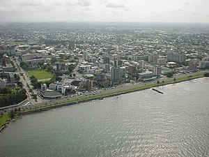
Libreville
Capital and largest city of Gabon
Distance: Approx. 253 meters
Latitude and longitude: 0.39027778,9.45416667
Libreville (/ˈlibrəˌvil/; French: [libʁəvil]) is the capital and largest city of Gabon, located on the Gabon Estuary. Libreville occupies 65 square kilometres (25 sq mi) of the northwestern province of Estuaire. Libreville is also a port on the Gabon Estuary, near the Gulf of Guinea.
Mont-Bouët
Market in Libreville, Gabon
Distance: Approx. 719 meters
Latitude and longitude: 0.3989,9.4528
The marché Mont-Bouët (Mont-Bouet market), in Libreville is Gabon's largest market, with hundreds of stalls selling fruits, vegetables, meat, poultry (live and dead), fabric, clothing, jewelry, household goods, traditional medicine and a variety of other goods. It is easy to get lost in the narrow passageways of the market and there are pickpockets, so visitors should keep track of their money and valuables at all times. On the outskirts of the market is a large shopping district.
Stade Omar Bongo
Distance: Approx. 187 meters
Latitude and longitude: 0.39180556,9.45216667
Stade Omar Bongo is a multi-purpose stadium in Libreville, Gabon. It is currently used mostly for football matches. It serves as the home ground of FC 105 Libreville.

National Assembly of Gabon
Distance: Approx. 2513 meters
Latitude and longitude: 0.4121,9.4425
The National Assembly (French: Assemblée Nationale) is the lower house of the Parliament of Gabon. It has 143 members, elected by Two round system The status of the Parliament is unclear following the coup d'état four days after the 2023 general election.

Battle of Gabon
WWII battle in colonial Gabon; Allied victory
Distance: Approx. 359 meters
Latitude and longitude: 0.39,9.45166667
The Battle of Gabon (French: Bataille du Gabon), also called the Gabon Campaign (Campagne du Gabon), occurred in November 1940 during World War II. The battle resulted in forces under the orders of General Charles de Gaulle taking the colony of Gabon and its capital, Libreville, from Vichy France, and the rallying of French Equatorial Africa to Free France.
Roman Catholic Archdiocese of Libreville
Roman Catholic archdiocese in Gabon
Distance: Approx. 2241 meters
Latitude and longitude: 0.4028,9.4364
The Roman Catholic Archdiocese of Libreville (French: Archidiocèse catholique romain de Libreville) is the Metropolitan See of the Latin Ecclesiastical province covering all Gabon. Its cathedral episcopal see is the Cathédrale Notre Dame de l’Assomption of Libreville, the national capital, which also has a former cathedral of the same name (both dedicated to the Assumption of Mary).
Stade Augustin Monédan de Sibang
Distance: Approx. 3040 meters
Latitude and longitude: 0.4161976,9.4672676
The Stade Augustin Monédan de Sibang is a stadium primarily used for football matches in Libreville, Gabon. It is the home of the Gabonese teams Sogéa FC, Missile FC, and Cercle Mbéri Sportif of the Gabon Championnat National D1. The stadium has capacity to 7,000 people.
Libreville Hospital
Hospital in Libreville, Gabon
Distance: Approx. 835 meters
Latitude and longitude: 0.388,9.4597
Libreville Hospital (French: Centre Hospitalier de Libreville, CHL) is the largest and most important hospital in Gabon. Located in the nation's capital of Libreville, the hospital has an accident and emergency department which serves much of the country. The hospital treated soldiers during the 2009 Gabonese helicopter crash.

Estuaire Province
Province of Gabon
Distance: Approx. 2740 meters
Latitude and longitude: 0.39444444,9.42916667
Estuaire is the most populous of Gabon's nine provinces. It covers an area of 20,740 km2. The provincial capital is Akanda, but the largest city is Libreville, Gabon's national capital.
Palais des Sports de Libreville
Multi-sports arena in Libreville, Gabon
Distance: Approx. 261 meters
Latitude and longitude: 0.3947,9.4529
The Palais des Sports de Libreville is a multisport use arena situated in Libreville, Gabon. The arena was built to host the 2018 African Men's Handball Championship and all of the tournament's games were held there. Nevertheless, the arena can be used to hold games of handball, volleyball, basketball and other team or individual sports.
Palais du bord de mer
Official residence of the president of Gabon
Distance: Approx. 1302 meters
Latitude and longitude: 0.3924,9.442
The Palais du bord de mer (English: Seaside Palace) is the official residence of the president of Gabon. Located in the capital city of Libreville, it was built in 1977 by President Omar Bongo. It is the work of the Lebanese-Ivorian architect Pierre Fakhoury.

Embassy of the United States, Libreville
Diplomatic mission of the United States of America to the Gabonese Republic
Distance: Approx. 3014 meters
Latitude and longitude: 0.41611111,9.46694444
The Embassy of the United States in Libreville is the diplomatic mission of the United States of America in Gabon. The U.S. Ambassador to Gabon is also responsible for diplomatic relations with São Tomé and Príncipe.
Weather in this IP's area
few clouds
27 Celsius
31 Celsius
27 Celsius
27 Celsius
1013 hPa
89 %
1013 hPa
1012 hPa
10000 meters
3.09 m/s
170 degree
20 %