153.33.138.203 - IP Lookup: Free IP Address Lookup, Postal Code Lookup, IP Location Lookup, IP ASN, Public IP
Country:
Region:
City:
Location:
Time Zone:
Postal Code:
IP information under different IP Channel
ip-api
Country
Region
City
ASN
Time Zone
ISP
Blacklist
Proxy
Latitude
Longitude
Postal
Route
Luminati
Country
Region
tx
City
denton
ASN
Time Zone
America/Chicago
ISP
PAVLOVMEDIA
Latitude
Longitude
Postal
IPinfo
Country
Region
City
ASN
Time Zone
ISP
Blacklist
Proxy
Latitude
Longitude
Postal
Route
IP2Location
153.33.138.203Country
Region
texas
City
denton
Time Zone
America/Chicago
ISP
Language
User-Agent
Latitude
Longitude
Postal
db-ip
Country
Region
City
ASN
Time Zone
ISP
Blacklist
Proxy
Latitude
Longitude
Postal
Route
ipdata
Country
Region
City
ASN
Time Zone
ISP
Blacklist
Proxy
Latitude
Longitude
Postal
Route
Popular places and events near this IP address

Denton County, Texas
County in Texas, US
Distance: Approx. 4106 meters
Latitude and longitude: 33.2,-97.12
Denton County is located in the U.S. state of Texas. As of the 2020 census, its population was 906,422, making it the seventh-most populous county in Texas. The county seat is Denton.

Corinth, Texas
City in Texas, United States
Distance: Approx. 3897 meters
Latitude and longitude: 33.14388889,-97.07222222
Corinth ( kər-INTH) is a city in Denton County, Texas, United States; it is a part of the Dallas-Fort Worth metroplex. Its population was 22,634 at the 2020 census.

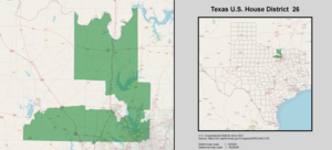
Texas's 26th congressional district
U.S. House district for Texas
Distance: Approx. 3451 meters
Latitude and longitude: 33.18472222,-97.13416667
Texas' 26th congressional district of the United States House of Representatives includes rural Cooke County to the north and some of Wise County to the West and includes parts of Denton County, including Flower Mound, Lewisville and parts of Corinth, Carrollton, Little Elm and The Colony. The current Representative is Michael C. Burgess. The district is best known as the seat of former House Majority Leader Dick Armey.

John H. Guyer High School
Public school in Denton, Texas, United States
Distance: Approx. 3602 meters
Latitude and longitude: 33.132891,-97.103311
John H. Guyer High School is a public high school situated in the city of Denton, Texas, in Denton County, United States and classified as a 6A school by the UIL. It is a part of the Denton Independent School District located in central Denton County. This was the third high school built by the district and was opened in 2005. In 2013, the school was rated "Academically Acceptable" by the Texas Education Agency.
Medical City Denton
Hospital in Texas, United States
Distance: Approx. 1878 meters
Latitude and longitude: 33.177,-97.091
Medical City Denton, (formerly Denton Regional Medical Center) or Denton Regional, is a hospital operated by Hospital Corporation of America and is located at 3535 South Interstate 35, southeast of downtown Denton, Texas. It houses 208 beds, and employs more than 850 employees and 300 physicians. Denton Regional serves patients from Denton, Wise, Cooke and Montague Counties.

Old Alton Bridge
United States historic place
Distance: Approx. 4015 meters
Latitude and longitude: 33.12916667,-97.10361111
Old Alton Bridge, also known as Goatman's Bridge, is a historic iron truss bridge connecting the Texas cities of Denton and Copper Canyon. Built in 1884 by the King Iron Bridge Manufacturing Company, it originally carried horses and later automobiles over Hickory Creek at a location that once was a popular ford for crossing cattle. The bridge takes its name from the abandoned community of Alton, which between 1850 and 1856 was the seat of Denton County.
Falcon Field (Corinth, Texas)
Baseball field in Corinth, Texas, US
Distance: Approx. 5548 meters
Latitude and longitude: 33.13513,-97.05793
Falcon Field is a baseball field in Corinth, Texas, US. It was the 2007 home of the defunct Denton Outlaws of the Texas Collegiate League. The field is now home to the Falcons of Lake Dallas High School.

Downtown Denton Transit Center
Intermodal transit center in Denton, Texas
Distance: Approx. 5772 meters
Latitude and longitude: 33.214,-97.126351
The Downtown Denton Transit Center is an intermodal public transit station in Denton, Texas. The station, operated by the Denton County Transportation Authority (DCTA), serves as the northern terminus of the A-train, a transfer center for the DCTA Connect bus system, and a hub for the GoZone Denton microtransit system. The station also hosts DCTA's customer service center.

MedPark station
A-train commuter rail station in Denton, Texas
Distance: Approx. 2374 meters
Latitude and longitude: 33.180234,-97.087331
MedPark station is a A-train commuter rail station in southern Denton, Texas. The station is operated by the Denton County Transportation Authority (DCTA). The station is approximately 1 mile (1.6 km) southeast of the intersection of Interstate 35E and Texas State Highway Loop 288.
Selwyn College Preparatory School
Private high school in Argyle, Texas, United States
Distance: Approx. 4999 meters
Latitude and longitude: 33.120459,-97.1100392
The Selwyn College Preparatory School is a school in Argyle, Texas. On January 21, 2012 the school's main building along with the kindergarten-5th grade classroom building burnt to the ground. In 2016, Selwyn relocated to Argyle, Texas.
Rector Road Bridge
United States historic place
Distance: Approx. 4013 meters
Latitude and longitude: 33.12916667,-97.10416667
Rector Road Bridge is a historic truss bridge in Denton, Texas. It was added to the National Register of Historic Places in 2004. It is a 5-panel, pinned Pratt through-truss bridge with I-beam approach spans.
Lake Dallas High School
Public school in Corinth, Texas, United States
Distance: Approx. 5433 meters
Latitude and longitude: 33.1328,-97.0618
Lake Dallas High School is a public high school located in the city of Corinth, Texas. It is classified as a 4A school by the UIL. It is part of the Lake Dallas Independent School District located in central Denton County. In 2015, the school was rated "Met Standard" by the Texas Education Agency.
Weather in this IP's area
clear sky
11 Celsius
9 Celsius
10 Celsius
12 Celsius
1032 hPa
45 %
1032 hPa
1009 hPa
10000 meters
7.2 m/s
20 degree
