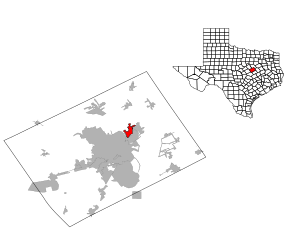
Country:
Region:
City:
Latitude and Longitude:
Time Zone:
Postal Code:
IP information under different IP Channel
ip-api
Country
Region
City
ASN
Time Zone
ISP
Blacklist
Proxy
Latitude
Longitude
Postal
Route
Luminati
Country
Region
tx
City
waco
ASN
Time Zone
America/Chicago
ISP
PAVLOVMEDIA
Latitude
Longitude
Postal
IPinfo
Country
Region
City
ASN
Time Zone
ISP
Blacklist
Proxy
Latitude
Longitude
Postal
Route
db-ip
Country
Region
City
ASN
Time Zone
ISP
Blacklist
Proxy
Latitude
Longitude
Postal
Route
ipdata
Country
Region
City
ASN
Time Zone
ISP
Blacklist
Proxy
Latitude
Longitude
Postal
Route
Popular places and events near this IP address
Bellmead, Texas
City in Texas, United States
Distance: Approx. 3027 meters
Latitude and longitude: 31.61333333,-97.08666667
Bellmead is a city in McLennan County, Texas, United States. The population was 10,494 at the 2020 census. It is part of the Waco Metropolitan Statistical Area.

Lacy Lakeview, Texas
City in Texas, United States
Distance: Approx. 2322 meters
Latitude and longitude: 31.62361111,-97.10944444
Lacy Lakeview is a city in McLennan County, Texas, United States. It is part of the Waco Metropolitan Statistical Area. The population was 6,988 at the 2020 census.
Elm Mott, Texas
Unincorporated community in Texas, US
Distance: Approx. 3608 meters
Latitude and longitude: 31.67194444,-97.09888889
Elm Mott is an unincorporated community in McLennan County, Texas, United States. It is located near the intersection of Interstate 35 and Farm to Market Road 308, eight miles north of Waco. Elm Mott is part of the Waco Metropolitan Statistical Area.
Texas State Technical College – Waco
Distance: Approx. 871 meters
Latitude and longitude: 31.639362,-97.084822
Texas State Technical College of Waco is a public technical college in Waco, Texas. It was founded in 1965 as the James Connally Technical Institute of Texas A&M University. Texas State Technical College is the only state-supported technical college system in Texas, and is accredited by the Commission on Colleges of the Southern Association of Colleges and Schools.
La Vega Independent School District
School district in Texas
Distance: Approx. 5260 meters
Latitude and longitude: 31.5934,-97.0835
La Vega Independent School District is a public school district based in Bellmead, Texas (USA). The district is located in central McLennan County and serves the city of Bellmead and parts of Waco. "academically acceptable" by the Texas Education Agency.
Northcrest, Texas
Distance: Approx. 645 meters
Latitude and longitude: 31.63666667,-97.09972222
Northcrest was a city in north central McLennan County, Texas (USA). The city's name came from its location (six miles) north of Waco and its elevation, which is the highest in the Waco area. Northcrest was incorporated as a city in February 1958 with a mayor–council form of government.

James Connally Air Force Base
Former USAF base, now TSTC Waco Airport.
Distance: Approx. 1424 meters
Latitude and longitude: 31.63777778,-97.07916667
James Connally Air Force Base was a United States Air Force base located north of Waco, Texas. After its closure in 1968, the airport reopened as TSTC Waco Airport.

TSTC Waco Airport
Airport in Texas
Distance: Approx. 1893 meters
Latitude and longitude: 31.63777778,-97.07416667
TSTC Waco Airport (IATA: CNW, ICAO: KCNW, FAA LID: CNW) is a public use airport located eight nautical miles (9 mi, 15 km) northeast of the central business district of Waco, a city in McLennan County, Texas, United States. Before 1968, it was known as James Connally Air Force Base. The airport is owned by Texas State Technical College.

Connally High School (Waco, Texas)
Public high school in Waco, Texas, United States
Distance: Approx. 841 meters
Latitude and longitude: 31.64242,-97.102326
Connally High School is a public high school located in Waco, Texas, United States and classified as a 4A school by the UIL. It is part of the Connally Independent School District located in northern McLennan County. In 2015, the school was rated "Met Standard" by the Texas Education Agency.
La Vega High School
Public school in Waco, Texas, United States
Distance: Approx. 4239 meters
Latitude and longitude: 31.6019,-97.0983
La Vega High School is a public high school located in the city of Bellmead, Texas, United States and classified as a 4A school by the University Interscholastic League (UIL). It is a part of the La Vega Independent School District located in central McLennan County and also includes students from Waco. When the school opened, only white students were allowed to attend.
George Washington Carver High School (Waco, Texas)
Public school in Waco, Texas, U.S.
Distance: Approx. 7481 meters
Latitude and longitude: 31.58,-97.13
George Washington Carver High School was a public secondary school in the La Vega Independent School District in Waco, Texas. It served as the high school for black students from 1956 until the public schools were integrated in 1970.
Greenwood Cemetery (Waco)
Cemetery in Waco, Texas
Distance: Approx. 7743 meters
Latitude and longitude: 31.5719,-97.1117
Greenwood Cemetery is a cemetery in Waco, Texas. It was racially segregated for its entire history as a burial place, starting with its origins in the 1870s. It is one of the two oldest cemeteries in Waco along with Oakwood Cemetery.
Weather in this IP's area
mist
22 Celsius
23 Celsius
22 Celsius
22 Celsius
1014 hPa
93 %
1014 hPa
996 hPa
3219 meters
3.09 m/s
90 degree
100 %
06:50:52
17:33:32