152.65.209.126 - IP Lookup: Free IP Address Lookup, Postal Code Lookup, IP Location Lookup, IP ASN, Public IP
Country:
Region:
City:
Location:
Time Zone:
Postal Code:
IP information under different IP Channel
ip-api
Country
Region
City
ASN
Time Zone
ISP
Blacklist
Proxy
Latitude
Longitude
Postal
Route
Luminati
Country
Region
04
City
dammam
ASN
Time Zone
Asia/Riyadh
ISP
Latitude
Longitude
Postal
IPinfo
Country
Region
City
ASN
Time Zone
ISP
Blacklist
Proxy
Latitude
Longitude
Postal
Route
IP2Location
152.65.209.126Country
Region
ash sharqiyah
City
dammam
Time Zone
Asia/Riyadh
ISP
Language
User-Agent
Latitude
Longitude
Postal
db-ip
Country
Region
City
ASN
Time Zone
ISP
Blacklist
Proxy
Latitude
Longitude
Postal
Route
ipdata
Country
Region
City
ASN
Time Zone
ISP
Blacklist
Proxy
Latitude
Longitude
Postal
Route
Popular places and events near this IP address

Dammam
Capital of Eastern Province, Saudi Arabia
Distance: Approx. 359 meters
Latitude and longitude: 26.43333333,50.1
Dammam (Arabic: الدمّام ad-Dammām) is the capital of the Eastern Province of Saudi Arabia. Situated on the coast of the Arabian Gulf. With a population of 1,386,166 as of 2022, Dammam is the kingdom's fifth-most populous city after Riyadh, Jeddah, Mecca, and Medina.
King Faisal University
Saudi Arabian university
Distance: Approx. 9843 meters
Latitude and longitude: 26.3885,50.18777778
King Faisal University (KFU) (Arabic: جامعة الملك فيصل Ğāmiʿat al-Malak Fayṣal) is a public university in Hofuf, Saudi Arabia. Founded in 1975, it is named after King Faisal bin Abdulalziz, the ruler of Saudi Arabia from 1964 until 1975. KFU was initially established with four colleges: two in Dammam and the other two in Al-Ahsa.

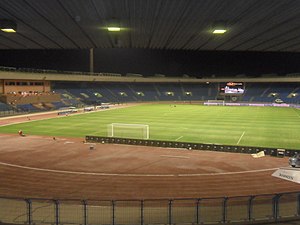
Prince Mohamed bin Fahd Stadium
Stadium in Dammam, Saudi Arabia
Distance: Approx. 1333 meters
Latitude and longitude: 26.427212,50.114093
The Prince Mohammad bin Fahd Stadium (Arabic: ملعب الأمير محمد بن فهد) is a multi-purpose stadium in Dammam, Saudi Arabia. It was built in 1973 and named after Muhammad bin Fahd, former governor of the Eastern Province. It was the first football stadium in the province.

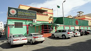
Bangladesh International School, Dammam
International school in Dammam, Eastern Province, Saudi Arabia
Distance: Approx. 2134 meters
Latitude and longitude: 26.4223,50.0868
Bangladesh International School Dammam is an English medium international school located in Dammam, Eastern Province, Saudi Arabia.
Dammam Community College
Distance: Approx. 4689 meters
Latitude and longitude: 26.39527778,50.12083333
Dammam Community College (كلية المجتمع في الدمام) is a college located in Saudi Arabia Eastern Province. The college offers two years Associate Degree with six majors, Computer and Information Technology, Accounting, Marketing, Supply Chain Management, Human Resource Management and Safety Technology. Part-time option is also available for Saudi nationals as well as for expats and foreigners.

International Indian School, Dammam
Public school in Al Safa, Ad Dammam, Eastern Province, Saudi Arabia
Distance: Approx. 9725 meters
Latitude and longitude: 26.38316664,50.18240973
International Indian School Dammam (IISD) (formerly Indian Embassy School Dammam) is an English-medium K-12 Indian school in Saudi Arabia. It is the largest school in the MENA region by number of students and second largest school in Asia. Most of its 15000+ students come from in and around Ad-Dammam, Al-Khobar, Abqaiq, Al Qatif, Al-Hofuf, and Ras Tanura.

Imam Abdulrahman Bin Faisal University
University in Saudi Arabia
Distance: Approx. 9692 meters
Latitude and longitude: 26.39388889,50.18944444
Imam Abdulrahman Bin Faisal University (IAU), formerly known as the University of Dammam, is a public university in Dammam, Saudi Arabia. It is one of the oldest and leading universities in medicine in the country's Eastern Province. It is named after Abdul Rahman bin Faisal, the last ruler of the Second Saudi State and the father of King Abdulalziz ibn Saud, the founder and first monarch of Saudi Arabia Dr.

King Fahad Specialist Hospital Dammam
Hospital in Eastern Region, Saudi Arabia
Distance: Approx. 2485 meters
Latitude and longitude: 26.41208,50.10288
King Fahad Specialist Hospital-Dammam (Arabic: مستشفى الملك فهد التخصصي بالدمام) (KFSHD) is a district general hospital in the Eastern region of Saudi Arabia.
Al-Ghad International Health Sciences Colleges
Private school in Riyadh, Saudi Arabia
Distance: Approx. 2695 meters
Latitude and longitude: 26.45051389,50.08321944
Al-Ghad International Health Sciences Colleges (AIHSC, Arabic: كليات الغد الدولية للعلوم الصحية) are private Colleges headquartered in Riyadh, Saudi Arabia, founded in 2009 by his excellency Sheikh Ibrahim bin Musa Al-zwaid, Chairman of the Board of Trustees of the colleges, Al-Ghad Colleges are one of the first colleges in the kingdom providing education in Applied Health professions. The Colleges were created to meet the shortage of skilled health sciences workers in Saudi Arabia. The student body of AIHSC today consists of about 7,000 students of both sexes.

Dammam railway station
Railway station in Saudi Arabia
Distance: Approx. 3553 meters
Latitude and longitude: 26.4101,50.1265
Dammam Station (Arabic: محطة الدمام, romanized: Maḥatṭat Dammam) is the railway station serving the city of Dammam. It is the eastern terminus of the Dammam–Riyadh Line and one of the three railway stations with active passenger transport in the Eastern Province. The station also serves as the station of operations for the Saudi Railway Company (SAR).
Dammam College of Technology
Distance: Approx. 5581 meters
Latitude and longitude: 26.386,50.118
Dammam College of Technology is a governmental technical college located in Dammam, eastern Saudi Arabia, was founded in 1986. The college mainly focuses on technical and vocational training to prepare students for careers. It is one of the technical colleges that are governed by the Technical and Vocational Training Corporation (TVTC), the government provider of training in the kingdom.
Othaim Mall
Shopping centre in Damman, Saudi Arabia
Distance: Approx. 4052 meters
Latitude and longitude: 26.399964,50.1165625
Olthaim Mall also known as Al Othaim Mall is a shopping centre in Damman, Saudi Arabia. It has 91,748 square metres (987,570 sq ft) of gross leasable area. It is owned by Al Othaim Investment Company.
Weather in this IP's area
mist
9 Celsius
9 Celsius
9 Celsius
9 Celsius
1021 hPa
93 %
1021 hPa
1020 hPa
5000 meters
1.54 m/s
5 %