152.53.75.84 - IP Lookup: Free IP Address Lookup, Postal Code Lookup, IP Location Lookup, IP ASN, Public IP
Country:
Region:
City:
Location:
Time Zone:
Postal Code:
IP information under different IP Channel
ip-api
Country
Region
City
ASN
Time Zone
ISP
Blacklist
Proxy
Latitude
Longitude
Postal
Route
Luminati
Country
Region
hi
City
honolulu
ASN
Time Zone
Pacific/Honolulu
ISP
ANEXIA Internetdienstleistungs GmbH
Latitude
Longitude
Postal
IPinfo
Country
Region
City
ASN
Time Zone
ISP
Blacklist
Proxy
Latitude
Longitude
Postal
Route
IP2Location
152.53.75.84Country
Region
hawaii
City
honolulu
Time Zone
Pacific/Honolulu
ISP
Language
User-Agent
Latitude
Longitude
Postal
db-ip
Country
Region
City
ASN
Time Zone
ISP
Blacklist
Proxy
Latitude
Longitude
Postal
Route
ipdata
Country
Region
City
ASN
Time Zone
ISP
Blacklist
Proxy
Latitude
Longitude
Postal
Route
Popular places and events near this IP address

Honolulu
Capital city of the U.S. state of Hawaii
Distance: Approx. 131 meters
Latitude and longitude: 21.30694444,-157.85833333
Honolulu ( HON-ə-LOO-loo; Hawaiian: [honoˈlulu]) is the capital and most populous city of the U.S. state of Hawaii, located in the Pacific Ocean. It is the county seat of the consolidated City and County of Honolulu, situated along the southeast coast of the island of Oʻahu, and is the westernmost and southernmost major U.S. city. Honolulu is Hawaii's main gateway to the world.

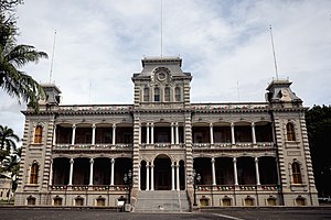
ʻIolani Palace
Royal palace in Honolulu, Hawaii
Distance: Approx. 130 meters
Latitude and longitude: 21.30666667,-157.85888889
The ʻIolani Palace (Hawaiian: Hale Aliʻi ʻIolani) was the royal residence of the rulers of the Kingdom of Hawaiʻi beginning with Kamehameha III under the Kamehameha Dynasty (1845) and ending with Queen Liliʻuokalani (1893) under the Kalākaua Dynasty, founded by her brother, King David Kalākaua. It is located in the capitol district of downtown Honolulu in the U.S. state of Hawaiʻi. It is now a National Historic Landmark listed on the National Register of Historic Places.

Hawaii State Capitol
State capitol building of the U.S. state of Hawaii
Distance: Approx. 179 meters
Latitude and longitude: 21.3075,-157.8575
The Hawaii State Capitol is the official statehouse or capitol building of the U.S. state of Hawaii. From its chambers, the executive and legislative branches perform the duties involved in governing the state. The Hawaii State Legislature—composed of the twenty-five member Hawaii State Senate led by the President of the Senate and the fifty-one member Hawaii State House of Representatives led by the Speaker of the House—convenes in the building.

ʻIolani Barracks
United States historic place
Distance: Approx. 46 meters
Latitude and longitude: 21.3075,-157.85888889
ʻIolani Barracks, or hale koa (house [of] warriors) in Hawaiian, was built in 1870, designed by the architect Theodore Heuck, under the direction of King Lot Kapuaiwa. Located directly adjacent to ʻIolani Palace in downtown Honolulu, it housed about 80 members of the monarch's Royal Guard until the overthrow of the Monarchy in 1893. It was added to the National Register of Historic Places in 1978 as part of the Hawaii Capital Historic District.

Hawaii House of Representatives
Lower house of the Hawaii State Legislature
Distance: Approx. 215 meters
Latitude and longitude: 21.30722222,-157.85722222
The Hawaii House of Representatives (Hawaiian: Hale o nā Luna Maka‘āinana) is the lower house of the Hawaii State Legislature. Pursuant to Article III, Section 3 of the Constitution of Hawaii, amended during the 1978 constitutional convention, the House of Representatives consists of 51 members representing an equal number of districts across the islands. It is led by the Speaker of the House elected from the membership of the House, with majority and minority leaders elected from their party's respective caucuses.

Hawaii Senate
Upper house of the Hawaii State Legislature
Distance: Approx. 206 meters
Latitude and longitude: 21.30733333,-157.85727778
The Hawaii State Senate (Hawaiian: Ka ‘Aha Kenekoa) is the upper house of the Hawaii State Legislature. It consists of twenty-five members elected from an equal number of constituent districts across the islands and is led by the President of the Senate, elected from the membership of the body, currently Ron Kouchi. The forerunner of the Hawaii Senate during the government of the Kingdom of Hawaii was the House of Nobles originated in 1840.

Statue of Father Damien
Sculpture by Marisol Escobar
Distance: Approx. 234 meters
Latitude and longitude: 21.3077,-157.85694167
The Father Damien Statue, also called the Saint Damien of Molokaʻi Statue, is the centerpiece of the entrance to the Hawaiʻi State Capitol and the Hawaiʻi State Legislature in Honolulu, Hawaiʻi. A second bronze cast is displayed in the National Statuary Hall Collection in the United States Capitol, along with the Kamehameha Statue. The landmark memorializes the famous Hawaiʻi Catholic Church priest from Belgium who sacrificed his life for the lepers of the island of Molokaʻi.
Myron B. Thompson Academy
New century public charter, online school in Honolulu, Hawaiʻi, United States
Distance: Approx. 46 meters
Latitude and longitude: 21.30762,-157.8596
Myron B. Thompson Academy, commonly referred to as Thompson Academy or MBTA, is an e-learning institution operating as a "New Century Public Charter School" under the Hawaiʻi Department of Education. Thompson Academy is the result of a white paper study developed by the school's principal, Diana Oshiro, detailing the feasibility of a school delivered over the internet. Established in 1999 as Hawaii e-Charter, Thompson Academy is available to students across the state of Hawaiʻi exclusively through the internet, as an alternative-of-choice to local schools.
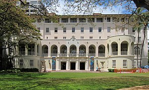
No. 1 Capitol District Building
Building in Honolulu, Hawaii, United States
Distance: Approx. 127 meters
Latitude and longitude: 21.30861111,-157.85833333
The No. 1 Capitol District Building, also known as the Hemmeter Building, is a 134,000-square-foot building (12,400 m2) on two acres (0.81 ha) in downtown Honolulu, Hawaii, United States. Formerly known as the Armed Services YMCA Building, it houses the Capitol Modern Museum, the Hawaii State Foundation on Culture and the Arts, and state offices.

Kauikeaouli Hale
District courthouse for the Island of Oʻahu in Hawaii
Distance: Approx. 136 meters
Latitude and longitude: 21.30888889,-157.85861111
Kauikeaouli Hale is a district courthouse for the Island of Oʻahu in Hawaii. It is located at 1111 Alakea Street between downtown Honolulu and the Hawaii Capital Historic District at 21°18′32″N 157°51′31″W. Its lower floors house the courts of the first circuit, covering the City and County of Honolulu, and upper floors have offices of some support departments of the Hawaii Supreme Court. It is adjacent to the Hawaii State Art Museum.

Alexander Young Hotel
United States historic place
Distance: Approx. 189 meters
Latitude and longitude: 21.30916667,-157.86027778
The Alexander Young Hotel was one of the first hotels in downtown Honolulu, Hawaii, opened in 1903. The hotel closed and was converted to offices in 1964. The structure was demolished in 1981.
Capitol Modern
Museum in Honolulu, Hawaii, United States
Distance: Approx. 127 meters
Latitude and longitude: 21.30861111,-157.85833333
The Capitol Modern Museum, formerly (until 2023) named the Hawaii State Art Museum, is a small art gallery located on the second floor of the No. 1 Capitol District Building in downtown Honolulu, Hawaii, United States. Long known as HiSAM, the museum is operated by the Hawaii State Foundation on Culture and the Arts.
Weather in this IP's area
broken clouds
26 Celsius
26 Celsius
26 Celsius
27 Celsius
1016 hPa
78 %
1016 hPa
1014 hPa
10000 meters
4.63 m/s
220 degree
75 %
