152.44.90.206 - IP Lookup: Free IP Address Lookup, Postal Code Lookup, IP Location Lookup, IP ASN, Public IP
Country:
Region:
City:
Location:
Time Zone:
Postal Code:
ISP:
ASN:
language:
User-Agent:
Proxy IP:
Blacklist:
IP information under different IP Channel
ip-api
Country
Region
City
ASN
Time Zone
ISP
Blacklist
Proxy
Latitude
Longitude
Postal
Route
db-ip
Country
Region
City
ASN
Time Zone
ISP
Blacklist
Proxy
Latitude
Longitude
Postal
Route
IPinfo
Country
Region
City
ASN
Time Zone
ISP
Blacklist
Proxy
Latitude
Longitude
Postal
Route
IP2Location
152.44.90.206Country
Region
north carolina
City
boiling springs
Time Zone
America/New_York
ISP
Language
User-Agent
Latitude
Longitude
Postal
ipdata
Country
Region
City
ASN
Time Zone
ISP
Blacklist
Proxy
Latitude
Longitude
Postal
Route
Popular places and events near this IP address

Boiling Springs, North Carolina
Town in North Carolina, United States
Distance: Approx. 1695 meters
Latitude and longitude: 35.25194444,-81.66361111
Boiling Springs is a town in Cleveland County, North Carolina, United States and is located in the westernmost part of the Charlotte metropolitan area, located approximately 50 miles away from the city. As of the 2010 census, the town's population was 4,647. It is home to Gardner–Webb University.

Lattimore, North Carolina
Town in North Carolina, United States
Distance: Approx. 6823 meters
Latitude and longitude: 35.31527778,-81.66027778
Lattimore is a town in Cleveland County, North Carolina, United States. The population was 488 at the 2010 census.
Gardner–Webb University
Christian university in Boiling Springs, North Carolina, US
Distance: Approx. 2450 meters
Latitude and longitude: 35.2474562,-81.6706223
Gardner–Webb University (Gardner–Webb, GWU, or GW) is a private Christian liberal arts university in Boiling Springs, North Carolina. It was founded as Boiling Springs High School in 1905. Gardner–Webb is a classified among "Doctoral/Professional Universities".
Williams Observatory
Observatory
Distance: Approx. 2628 meters
Latitude and longitude: 35.24415,-81.67095
Craven E. Williams Observatory is an astronomical observatory owned and operated by Gardner-Webb University. Built in 1990 and named for the ninth president of the university, it is located in Boiling Springs, North Carolina (USA). Among its instruments, the observatory features a 16 in (41 cm) Schmidt-Cassegrain telescope.
Paul Porter Arena
Distance: Approx. 2395 meters
Latitude and longitude: 35.246538,-81.669518
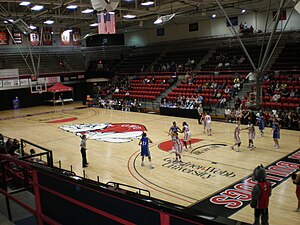
Paul Porter Arena is a 3,500-seat multi-purpose arena in Boiling Springs, North Carolina. It is home to the Gardner-Webb University Runnin' Bulldogs, of the Big South Conference. The Arena was named in honor of Paul B. Porter who was a Board of Advisors Honorary Member and Lifetime Member.
Ernest W. Spangler Stadium
Stadium in North Carolina
Distance: Approx. 2746 meters
Latitude and longitude: 35.245637,-81.673243
Ernest W. Spangler Stadium is a 9,000-seat multi-purpose stadium in Boiling Springs, North Carolina. It is home to the Gardner–Webb University Bulldogs football team. The facility opened in 1969.
John Henry Moss Stadium
Distance: Approx. 2521 meters
Latitude and longitude: 35.2433,-81.669
John Henry Moss Stadium is a baseball stadium home to the Gardner-Webb University Runnin' Bulldogs. It was officially completed on September 18, 2010. The first regular season game played there was February 22, 2011.

E. B. Hamrick Hall
Historic academic building in North Carolina
Distance: Approx. 2157 meters
Latitude and longitude: 35.24944444,-81.66805556
E. B. Hamrick Hall is a historic academic building located on the campus of Gardner-Webb University in Boiling Springs, Cleveland County, North Carolina. It currently houses the Godbold School of Business which encompasses both the undergraduate and graduate business programs of Gardner-Webb University. It was built between 1920 and 1925, and is a three-story, nine-bay, T-shaped, Colonial Revival-style brick building.

Irvin-Hamrick Log House
Historic house in North Carolina, United States
Distance: Approx. 2954 meters
Latitude and longitude: 35.27638889,-81.62583333
Irvin-Hamrick Log House is a historic home located near Boiling Springs, Cleveland County, North Carolina. It consists of log and frame sections. The front log section was built about 1795, and is a small, two room, rectangular, gable roof structure.

Joseph Suttle House
Historic house in North Carolina, United States
Distance: Approx. 5529 meters
Latitude and longitude: 35.26527778,-81.58583333
Joseph Suttle House, also known as Twin Chimneys, is a historic home located near Shelby, Cleveland County, North Carolina. It was built between 1820 and 1847, and is a two-story, three-bay, gable-roofed frame dwelling with Federal style design elements. It features two stuccoed, smooth shouldered exterior chimneys.

Broad River Greenway
Distance: Approx. 6179 meters
Latitude and longitude: 35.20177778,-81.66383333
The Broad River Greenway was established in 1994 as a regional park for Cleveland County, NC.This site has been associated with recreation, long before the land was permanently protected. Duke Energy established the Palmer Shoals Canoe Access Area on the Broad River, as part of a FERC licence issued for the Cliffside Steam Station., just upstream.
Crest High School (North Carolina)
Public secondary school in Shelby, North Carolina (USA)
Distance: Approx. 3787 meters
Latitude and longitude: 35.2726,-81.6096
Crest High School is a public high school in Shelby, North Carolina. It is part of the Cleveland County Schools district.
Weather in this IP's area
clear sky
-5 Celsius
-5 Celsius
-5 Celsius
-4 Celsius
1031 hPa
57 %
1031 hPa
997 hPa
10000 meters
0.45 m/s
0.89 m/s
33 degree
