Country:
 Afghanistan
Region:
City:
Latitude and Longitude:
Time Zone:
Postal Code:
IP information under different IP Channel
ip-api
Country
Region
City
ASN
Time Zone
ISP
Blacklist
Proxy
Latitude
Longitude
Postal
Route
IPinfo
Country
Region
City
ASN
Time Zone
ISP
Blacklist
Proxy
Latitude
Longitude
Postal
Route
MaxMind
Country
Region
City
ASN
Time Zone
ISP
Blacklist
Proxy
Latitude
Longitude
Postal
Route
Luminati
Country
AFASN
Time Zone
Asia/Kabul
ISP
Afghan Wireless Communication Company
Latitude
Longitude
Postal
db-ip
Country
Region
City
ASN
Time Zone
ISP
Blacklist
Proxy
Latitude
Longitude
Postal
Route
ipdata
Country
Region
City
ASN
Time Zone
ISP
Blacklist
Proxy
Latitude
Longitude
Postal
Route
Popular places and events near this IP address
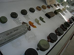
OMAR Mine Museum
Distance: Approx. 718 meters
Latitude and longitude: 34.55986111,69.20183889
The OMAR Mine Museum in Kabul, Afghanistan, contains a collection of 51 types of land mines out of the 53 that have been used in that country. OMAR is an acronym for the Organization for Mine Clearance and Afghan Rehabilitation.

Kabul International Airport
International airport near Kabul, Afghanistan
Distance: Approx. 1268 meters
Latitude and longitude: 34.56583333,69.21305556
Kabul International Airport (IATA: KBL, ICAO: OAKB) is located in the northern part of Kabul, Afghanistan. It is one of the country's main international airports, capable of housing over a hundred military and civilian aircraft. It is currently operated by UAE-based GAAC Holding and Afghanistan's Ministry of Transport and Civil Aviation.
Ministry of Borders and Tribal Affairs
Distance: Approx. 2170 meters
Latitude and longitude: 34.538688,69.195313
The Ministry of Borders and Tribal Affairs (Pashto: د سرحدونو او قبایلو چارو وزارت), (Dari: وزارت امور سرحدات، اقوام و قبایل) is an organ of the Central Government of Afghanistan.

Abdul Hadi Dawi High School
Public school in District , Kabul, Afghanistan
Distance: Approx. 2304 meters
Latitude and longitude: 34.537,69.196
Abdul Hadi Dawi High School, located in Kabul's District 9 near the 3rd Mikrorayon, is named after Abdul Hadi Dawi (Abdul Hadi Dawai), a renowned Afghan poet, diplomat and government official. The High school is generally for boys and was first constructed during the Babrak Karmal regime with the aid and support of former Soviet Union government that backed the Afghan Communist Party both financially and militarily at the time. At first it was named Enqelaab (Revolution) High School in commemoration of the 7th of Saur Revolution, but during Najibullah's presidency its name was changed to Abdul Hadi Dawi High School.
Holyport College
Free school in Holyport, Berkshire, England
Distance: Approx. 11 meters
Latitude and longitude: 34.5553,69.2075
Holyport College is a mixed boarding free school (the boarding option for students is not free). The school is located in Holyport, Berkshire, England. It opened in 2014 and caters for students aged 11–19 years.
April 2016 Kabul attack
Terrorist attack in Kabul, Afghanistan
Distance: Approx. 11 meters
Latitude and longitude: 34.5553,69.2075
On the morning of 19 April 2016, Taliban militants attacked a security team responsible for protecting government VIPs in Kabul, Afghanistan. The initial attack killed 64 people and wounded 347. It was their biggest attack on an urban area since 2001.

Daoud Khan Military Hospital
Hospital in Kabul, Afghanistan
Distance: Approx. 2344 meters
Latitude and longitude: 34.5414,69.1884
The Sardar Mohammad Daoud Khan National Military Hospital, often referred to as the Daoud Khan Hospital or the National Military Hospital, is a military hospital located in Kabul, Afghanistan. With 400 beds, it is one of the largest military medical facilities in Afghanistan, and prior to 2021 provided medical services to members of the Afghan National Security Forces, and also contains a teaching department. Constructed in 1973 by engineers from the then-Soviet Union, it is now described as the "crown jewel" of the Afghan healthcare industry.
Operation Devi Shakti
Evacuation of Indians from Afghanistan
Distance: Approx. 1268 meters
Latitude and longitude: 34.56583333,69.21305556
Operation Devi Shakti (transl. Operation Goddess Shakti) was an operation of the Indian Armed Forces to evacuate Indian citizens and foreign nationals from Afghanistan after the collapse of the Islamic Republic of Afghanistan and the fall of Kabul, the capital city, to the Taliban.
2021 Kabul airport attack
Suicide bombing at Kabul airport, Afghanistan
Distance: Approx. 1225 meters
Latitude and longitude: 34.55861111,69.22027778
A suicide bombing took place at Hamid Karzai International Airport in Kabul, Afghanistan, on 26 August 2021, at 17:50 local time (13:20 UTC), during the evacuation from Afghanistan. At least 182 people were killed, including 169 Afghan civilians and 13 members of the United States military, the first American military casualties in the War in Afghanistan since February 2020. The Islamic State – Khorasan Province (ISIS–K) claimed responsibility for the attack.
Operation Miracle (2021)
Distance: Approx. 1268 meters
Latitude and longitude: 34.56583333,69.21305556
Operation Miracle (Korean: 미라클 작전) was an operation of the Republic of Korea Armed Forces to evacuate Afghan collaborators from Afghanistan after the fall of Kabul, the capital city, to the Taliban. Three C-130J and one KC-330 Cygnus which is an Airbus A330 MRTT were used for evacuation, and 390 personnel were evacuated.
2023 Kabul airport bombing
2023 explosion in Kabul
Distance: Approx. 1225 meters
Latitude and longitude: 34.55861111,69.22027778
On 1 January 2023, a bombing occurred at a checkpoint outside the military airport in Kabul, located about 200 metres from the civilian Kabul International Airport in Afghanistan. It killed and injured several people. The following day, on 2 January, the Islamic State claimed responsibility for the bombing on Telegram, stating to have killed 20 people and injured 30.
Kabul ACC
Air traffic control facility
Distance: Approx. 1268 meters
Latitude and longitude: 34.56583333,69.21305556
The Kabul Area Control Centre (ICAO: OAKX) was the only en route area control center (ACC) in Afghanistan. From the Kabul Area Control Centre, air traffic controllers provided en route and terminal control services to aircraft in the Kabul Flight Information Region (FIR). The ACC was managed by the Civil Aviation Authority of the Islamic Republic of Afghanistan.
Weather in this IP's area
clear sky
28 Celsius
27 Celsius
28 Celsius
28 Celsius
1008 hPa
8 %
1008 hPa
826 hPa
10000 meters
1.56 m/s
1.78 m/s
113 degree
05:31:27
18:10:34