Country:
 Colombia
Region:
City:
Latitude and Longitude:
Time Zone:
Postal Code:
IP information under different IP Channel
ip-api
Country
Region
City
ASN
Time Zone
ISP
Blacklist
Proxy
Latitude
Longitude
Postal
Route
IPinfo
Country
Region
City
ASN
Time Zone
ISP
Blacklist
Proxy
Latitude
Longitude
Postal
Route
MaxMind
Country
Region
City
ASN
Time Zone
ISP
Blacklist
Proxy
Latitude
Longitude
Postal
Route
Luminati
Country
CORegion
dc
City
bogota
ASN
Time Zone
America/Bogota
ISP
EDGECAST
Latitude
Longitude
Postal
db-ip
Country
Region
City
ASN
Time Zone
ISP
Blacklist
Proxy
Latitude
Longitude
Postal
Route
ipdata
Country
Region
City
ASN
Time Zone
ISP
Blacklist
Proxy
Latitude
Longitude
Postal
Route
Popular places and events near this IP address
University of the Andes (Colombia)
Colombian university
Distance: Approx. 482 meters
Latitude and longitude: 4.601613,-74.065173
The University of the Andes (Spanish: Universidad de los Andes), also commonly self-styled as Uniandes, is a private research university located in the city centre of Bogotá, Colombia. Founded in 1948 by a group of Colombian intellectuals led by Mario Laserna Pinzón, it was the first Colombian university established as nonsectarian (independent from any political party or religious institution). The university is academically composed of nine schools, three special academic entities—the Alberto Lleras Camargo School of Government, the Center for Research and Training in Education (Spanish: Centro de Investigación y Formación en Educación, CIFE), and the Interdisciplinary Center for Development Studies (Spanish: Centro Interdisciplinario de Estudios sobre Desarrollo, CIDER)—and a joint academic venture with the medical institution Santa Fe de Bogotá Foundation, offering 31 undergraduate, 18 doctoral, and 38 graduate degree-granting programs in areas of human knowledge such as medicine, engineering, science, law and others.

Gold Museum, Bogotá
Museum in Bogota, Colombia
Distance: Approx. 289 meters
Latitude and longitude: 4.60191944,-74.072
The Museum of Gold (Spanish: Museo del Oro) is an archaeology museum located in Bogotá, Colombia. It is one of the most visited touristic highlights in the country. The museum receives around 500,000 tourists per year.
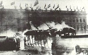
Bogotazo
1948 riots in Bogotá, Colombia over the assassination of pres. candidate Jorge Eliécer Gaitán
Distance: Approx. 516 meters
Latitude and longitude: 4.6005,-74.0741
El Bogotazo (from "Bogotá" and the -azo suffix of violent augmentation) was a massive outbreak of rioting after the assassination in Bogotá, Colombia of Liberal leader and presidential candidate Jorge Eliécer Gaitán on 9 April 1948 during the government of President Mariano Ospina Pérez. The 10-hour riot left much of downtown Bogotá destroyed. The aftershock of Gaitan's murder continued extending through the countryside and escalated a period of violence which had begun eighteen years before, in 1930, and was triggered by the fall of the conservative party from government and the rise of the liberals.
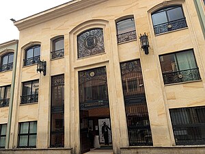
La Gran Colombia University
Distance: Approx. 397 meters
Latitude and longitude: 4.5996,-74.0727
La Gran Colombia University is a private university located in Bogotá, D.C., Colombia. It was founded on May 24, 1951, by Julio César García Valencia, recognized Colombian historian of the Twentieth century.

Bank of the Republic (Colombia)
Central bank of Colombia
Distance: Approx. 364 meters
Latitude and longitude: 4.60138889,-74.07277778
The Bank of the Republic (Spanish: Banco de la República) is the central bank of Colombia. It was initially established under the regeneration era in 1880. Its main modern functions, under the new Colombian constitution were detailed by Congress according to Ley 31 de 1992.
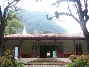
Quinta de Bolívar
Distance: Approx. 291 meters
Latitude and longitude: 4.602,-74.072
The Quinta de Bolivar is a colonial house in Bogota, Colombia, that served as a residence to Simon Bolivar in the capital after the war of independence. It is now used as a museum dedicated to Bolivar's life and times.

Central University (Colombia)
Private university in Bogotá, Colombia
Distance: Approx. 426 meters
Latitude and longitude: 4.601175,-74.06566111
The Central University (Universidad Central) is a private institution of higher education established 1966, whose two offices are at Bogotá, Colombia. It offers undergraduate and graduate programs in the areas of humanities, arts, economic and administrative sciences and engineering.
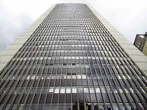
Avianca Building
Office in Bogotá, Colombia
Distance: Approx. 363 meters
Latitude and longitude: 4.6025,-74.0725
Avianca Building is a 161-meter-tall office skyscraper located at the intersection of 16th street and Seventh Avenue, next to Santander Park in the city of Bogotá, Colombia.

Silva Poetry House
Distance: Approx. 299 meters
Latitude and longitude: 4.5988,-74.0707
The Silva Poetry House is a Colombian historical cultural organization located in the Candelaria neighborhood of Bogotá. It was founded on May 24, 1986 by Belisario Betancur, in the house where the Colombian poet José Asunción Silva used to live. It has a library and a bookshop specializing in poetry, a music library, and an auditorium.
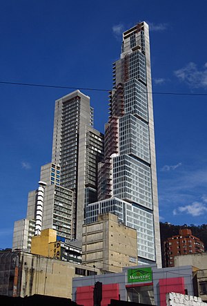
BD Bacatá
Mixed-use in Bogotá, Colombia
Distance: Approx. 406 meters
Latitude and longitude: 4.60475,-74.07033333
BD Bacatá (abbreviation for Bogotá Downtown Bacatá) is an architectural complex currently under construction in Bogotá, Colombia, featuring the tallest building in the country, surpassing the Torre Colpatria, and the sixth tallest in South America. The South Tower is 67 stories high and covers a total surface area of 1,200,000 square feet (111,480 m2). Development includes office and retail space, apartments and a 364-room hotel, replacing the former Hotel Bacatá that was constructed in the same location.

Conjunto Multifamiliar Torres Gonzalo Jiménez de Quesada
Residential in Bogotá, Colombia
Distance: Approx. 109 meters
Latitude and longitude: 4.60032222,-74.06993611
The Torres Gonzalo Jiménez de Quesada ("Gonzalo Jiménez de Quesada Towers") is a residential complex composed of five towers of equal height in the centre of the Colombian capital Bogotá. The buildings are situated in the neighbourhood (barrio) Las Aguas, in the northeast of La Candelaria.

Chorro de Quevedo
Distance: Approx. 382 meters
Latitude and longitude: 4.59777778,-74.06972222
Chorro de Quevedo (Quevedo's fountain) is a fountain located in the neighborhood of La Candelaria in Bogotá. It signifies the purported location where Gonzalo Jiménez de Quesada, a Spanish conquistador, first established the foundations of Bogotá in 1538. Also, it is considered the place where the Zipa, or chief of the Muisca tribe, would regularly survey the Bogotá savanna.
Weather in this IP's area
broken clouds
10 Celsius
10 Celsius
10 Celsius
10 Celsius
1019 hPa
87 %
1019 hPa
748 hPa
10000 meters
1.03 m/s
75 %
05:48:52
17:59:05