Country:
 Germany
Region:
City:
Latitude and Longitude:
Time Zone:
Postal Code:
IP information under different IP Channel
ip-api
Country
Region
City
ASN
Time Zone
ISP
Blacklist
Proxy
Latitude
Longitude
Postal
Route
IPinfo
Country
Region
City
ASN
Time Zone
ISP
Blacklist
Proxy
Latitude
Longitude
Postal
Route
MaxMind
Country
Region
City
ASN
Time Zone
ISP
Blacklist
Proxy
Latitude
Longitude
Postal
Route
Luminati
Country
DERegion
he
City
frankfurtammain
ASN
Time Zone
Europe/Berlin
ISP
EDGECAST
Latitude
Longitude
Postal
db-ip
Country
Region
City
ASN
Time Zone
ISP
Blacklist
Proxy
Latitude
Longitude
Postal
Route
ipdata
Country
Region
City
ASN
Time Zone
ISP
Blacklist
Proxy
Latitude
Longitude
Postal
Route
Popular places and events near this IP address

Schirn Kunsthalle Frankfurt
Art museum in Frankfurt, Germany
Distance: Approx. 212 meters
Latitude and longitude: 50.11027778,8.68361111
The Schirn Kunsthalle is a Kunsthalle in Frankfurt, Germany, located in the old city between the Römer and the Frankfurt Cathedral; it is part of Frankfurt's Museumsufer (Museum Riverbank). The Schirn exhibits both modern and contemporary art. It is the main venue for temporary art exhibitions in Frankfurt.

Portikus
Contemporary art exhibition hall
Distance: Approx. 245 meters
Latitude and longitude: 50.1081,8.6875
Portikus is an exhibition hall for contemporary art in Frankfurt am Main, that was founded in 1987 by Kasper König. The museum is part of Frankfurt's Museumsufer (Museum Riverbank). Portikus presents the work of both internationally renowned artists and emerging artists.

Free City of Frankfurt
Former city-state of Germany
Distance: Approx. 248 meters
Latitude and longitude: 50.11027778,8.68222222
Frankfurt was a major city of the Holy Roman Empire, being the seat of imperial elections since 885 and the city for imperial coronations from 1562 (previously in Free Imperial City of Aachen) until 1792. Frankfurt was declared an Imperial Free City (Freie und Reichsstadt) in 1372, making the city an entity of Imperial immediacy, meaning immediately subordinate to the Holy Roman Emperor and not to a regional ruler or a local nobleman. Due to its imperial significance, Frankfurt survived mediatisation in 1803.
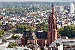
Frankfurt Cathedral
Church in Frankfurt am Main, Germany
Distance: Approx. 248 meters
Latitude and longitude: 50.11055556,8.685
Frankfurt Cathedral (German: Frankfurter Dom), officially Imperial Cathedral of Saint Bartholomew (German: Kaiserdom Sankt Bartholomäus), is a Roman Catholic Gothic church located in the heart of Frankfurt am Main, Germany. It is dedicated to Saint Bartholomew. It is the largest religious building in the city and a former collegiate church.
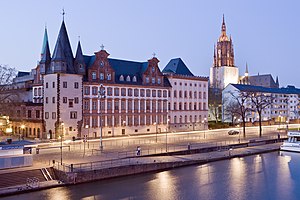
Historical Museum, Frankfurt
Museum in Frankfurt, Germany
Distance: Approx. 179 meters
Latitude and longitude: 50.1096,8.68244
The Historical Museum (German: Historisches Museum) in Frankfurt am Main, Germany, was founded in 1878, and includes cultural and historical objects relating to the history of Frankfurt and Germany. It moved into the Saalhof in 1955, and a new extension was opened in 1972. The 1970s extension is currently being replaced by a modern new exhibition building and a small administration building which are expected to be completed by 2015.

Römerberg (Frankfurt)
Public square in Frankfurt, Germany
Distance: Approx. 248 meters
Latitude and longitude: 50.11027778,8.68222222
Römerberg (also spelled as Roemerberg, lit. 'Roman Mountain') is a public space in Frankfurt, Germany. It is located in front of the Römer building complex, seat of the Frankfurt city administration since the 15th century. As the site of numerous imperial coronations, trade fairs and Christmas markets, the square is the historic heart of the medieval Altstadt (old town) and today a popular tourist destination.

Old St. Nicholas Church
Distance: Approx. 223 meters
Latitude and longitude: 50.11,8.68222222
The Old St. Nicholas Church (in German: Alte Nikolaikirche) in Frankfurt, Germany, is a medieval Lutheran church. It is located near the Römer city hall in Frankfurt's old town called Altstadt.

Dreikönigskirche, Frankfurt
Church building in Frankfurt, Germany
Distance: Approx. 156 meters
Latitude and longitude: 50.10722222,8.68527778
The Dreikönigskirche (English: Church of the Three Kings) is a Lutheran Protestant church and parish in Frankfurt, the city's largest Protestant parish. It is located on the south bank of the Main in Sachsenhausen, opposite the Frankfurt Cathedral. The present church building, replacing an older church, was erected from 1875 to 1880 on designs by Franz Josef Denzinger in Gothic revival style.
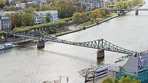
Eiserner Steg
Footbridge over the Main in Frankfurt
Distance: Approx. 140 meters
Latitude and longitude: 50.1081,8.6822
The Eiserner Steg (Iron Footbridge) is a footbridge spanning the river Main in the city of Frankfurt, Germany, which connects the centre of Frankfurt with the district of Sachsenhausen. The first wrought iron bridge was built in 1868. It was replaced in 1911/1912 by a slightly larger cantilever bridge.

Caricatura Museum Frankfurt
German museum for comic art
Distance: Approx. 210 meters
Latitude and longitude: 50.11013,8.68526
The Caricatura Museum, official name Caricatura Museum für Komische Kunst, is a museum for comic art in Frankfurt, Hesse, Germany. It shows a in a permanent exhibition works by the artists of the Neue Frankfurter Schule, and additionally exhibitions of contemporary artists. It is part of Frankfurt's Museumsufer (Museum Riverbank).

Haus zur goldenen Waage
Timber framed house
Distance: Approx. 255 meters
Latitude and longitude: 50.11069,8.68433
The Haus zur Goldenen Waage is a medieval half-timbered house in the old town of Frankfurt am Main, which was destroyed in the air raid on 22 March 1944. Because of its high architectural and historic value, it is one of the most famous sights of the city. It is situated in front of the main entrance of the cathedral on the corner of the narrow Höllgasse, which leads from the cathedral square to the Römerberg and Altstadtgasse.

Roseneck (Frankfurt am Main)
Former building in Germany
Distance: Approx. 250 meters
Latitude and longitude: 50.1102,8.6862
The Roseneck was a group of half-timbered houses in Frankfurt am Main. The small square was a tourist attraction and, alongside the Five-Finger Square, was one of the most popular postcard motifs in the picturesque old town (altstadt) of Frankfurt. The Roseneck was destroyed in the air raids on Frankfurt in 1944.
Weather in this IP's area
few clouds
21 Celsius
21 Celsius
20 Celsius
22 Celsius
1012 hPa
85 %
1012 hPa
1001 hPa
10000 meters
3.09 m/s
210 degree
20 %
06:51:08
19:54:56