Country:
 USA
USARegion:
City:
Latitude and Longitude:
Time Zone:
Postal Code:
IP information under different IP Channel
ip-api
Country
Region
City
ASN
Time Zone
ISP
Blacklist
Proxy
Latitude
Longitude
Postal
Route
IPinfo
Country
Region
City
ASN
Time Zone
ISP
Blacklist
Proxy
Latitude
Longitude
Postal
Route
MaxMind
Country
Region
City
ASN
Time Zone
ISP
Blacklist
Proxy
Latitude
Longitude
Postal
Route
Luminati
Country
USRegion
mi
City
royaloak
ASN
Time Zone
America/Detroit
ISP
123NET
Latitude
Longitude
Postal
db-ip
Country
Region
City
ASN
Time Zone
ISP
Blacklist
Proxy
Latitude
Longitude
Postal
Route
ipdata
Country
Region
City
ASN
Time Zone
ISP
Blacklist
Proxy
Latitude
Longitude
Postal
Route
Popular places and events near this IP address
Algiers Motel incident
Police brutality incident in Detroit
Distance: Approx. 2 meters
Latitude and longitude: 42.376121,-83.07751
The Algiers Motel incident (also called the Algiers Motel Murders) occurred in Detroit, Michigan, United States, throughout the night of July 25–26, 1967, during the racially charged 12th Street Riot. At the Algiers Motel, approximately one mile east of where the riot began, three civilians were killed and nine others abused by a riot task force composed of the Detroit Police Department, the Michigan State Police, and the Michigan Army National Guard. Among the casualties were three black teenage boys killed, and two white women and seven black men wounded as a result.

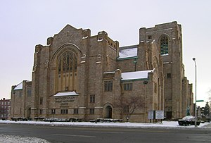
Bethel Community Transformation Center
United States historic place
Distance: Approx. 568 meters
Latitude and longitude: 42.38050556,-83.08098611
The former Temple Beth-El is a historic building located at 8801 Woodward Avenue (Woodward at Gladstone) in Detroit, Michigan. It was built in 1921 and listed on the National Register of Historic Places in 1982.

First Baptist Church (Detroit, Michigan)
Historic church in Michigan, United States
Distance: Approx. 353 meters
Latitude and longitude: 42.37881667,-83.07971667
The former First Baptist Church is a historic Baptist church building located at 8601 Woodward Avenue in Detroit, Michigan. Built in 1909, it was designed by architect Guy J. Vinton in the Late Gothic Revival style. It is now the Peoples Community Church.
Metropolitan United Methodist Church
Historic church in Michigan, United States
Distance: Approx. 219 meters
Latitude and longitude: 42.37465833,-83.07569167
The Metropolitan United Methodist Church is a church located at 8000 Woodward Avenue (at Chandler) in the New Center area of Detroit, Michigan. It was completed in 1926, listed on the National Register of Historic Places in 1982, and designated a Michigan State Historic Site in 1986. This church should not be confused with Metropolitan United Methodist Church in Washington, DC, which is often regarded as a National Church within the United States as it was specifically established by the General Conference to be a "representative presence of Methodism in the nation's capital".

North Woodward Congregational Church
Historic church in Michigan, United States
Distance: Approx. 460 meters
Latitude and longitude: 42.37970833,-83.08023056
The St. John's Christian Methodist Episcopal Church is a church located in Detroit, Michigan. It was built as the North Woodward Congregational Church, listed on the National Register of Historic Places in 1982, and designated a Michigan State Historic Site in 1998.

Woodward Avenue Presbyterian Church
Historic church in Michigan, United States
Distance: Approx. 258 meters
Latitude and longitude: 42.37792222,-83.07944444
The Woodward Avenue Presbyterian Church is a church located at 8501 Woodward Avenue in Detroit, Michigan. Built in 1911 in the Gothic Revival style, the architect was Sidney Badgley. It was used for some time as the Abyssinia Church of God in Christ.
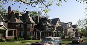
Virginia Park Historic District
Historic district in Michigan, United States
Distance: Approx. 369 meters
Latitude and longitude: 42.37444444,-83.08138889
The Virginia Park Historic District is located on the north side of New Center, an area in Detroit, Michigan, along both sides of Virginia Park Street from Woodward Avenue to the John C. Lodge Freeway access road. The district was listed on the National Register of Historic Places in 1982. The Virginia Park Historic District is an example of a well–preserved late nineteenth to early twentieth century residential community.

Religious Structures of Woodward Avenue Thematic Resource
United States historic place
Distance: Approx. 521 meters
Latitude and longitude: 42.38055556,-83.07944444
The Religious Structures of Woodward Avenue Thematic Resource (TR) is a multiple property submission to the National Register of Historic Places which was approved on August 3, 1982. The structures are located on Woodward Avenue in the cities of Detroit and Highland Park, Michigan.
Blanche Kelso Bruce Academy
High school in Detroit, Wayne County, Michigan
Distance: Approx. 333 meters
Latitude and longitude: 42.37358333,-83.07969444
Blanche Kelso Bruce Academy was the name given to several charter schools within the Detroit Public Schools in Detroit, Michigan, serving students in grades 5-12. They functioned as alternative schools for Youth Outside the Educational Mainstream (YOEM). Most of the schools were strict-discipline academies for students who had been expelled from regular schools.
WNUC-LP
Radio station in Michigan, United States
Distance: Approx. 407 meters
Latitude and longitude: 42.3725,-83.07833333
WNUC-LP (96.7 FM) is a community radio station in Detroit, Michigan, having launched in 2016 as a grassroots affiliate of Pacifica Radio. The station covers the immediate New Center neighborhood, and from Downtown Detroit to North End. Its format is a mixture of Urban Gospel and community talk radio.

WJBK-TV Studios Building
United States historic place
Distance: Approx. 555 meters
Latitude and longitude: 42.37111111,-83.0775
The WJBK-TV Studios Building is a broadcasting building located at 7441 Second Avenue in Detroit, Michigan. It was listed on the National Register of Historic Places in 2016. It is the only building in Detroit designed by noted Palm Beach, Florida architect John L. Volk.

Marwood Apartments
United States historic place
Distance: Approx. 176 meters
Latitude and longitude: 42.37554,-83.0755
The Marwood Apartments is an apartment building located at 53 Marston Street in Detroit, Michigan. It was listed on the National Register of Historic Places in 2019.
Weather in this IP's area
clear sky
9 Celsius
8 Celsius
7 Celsius
10 Celsius
1033 hPa
78 %
1033 hPa
1010 hPa
10000 meters
2.06 m/s
160 degree
07:49:03
18:45:20