Country:
 USA
USARegion:
City:
Latitude and Longitude:
Time Zone:
Postal Code:
IP information under different IP Channel
ip-api
Country
Region
City
ASN
Time Zone
ISP
Blacklist
Proxy
Latitude
Longitude
Postal
Route
IPinfo
Country
Region
City
ASN
Time Zone
ISP
Blacklist
Proxy
Latitude
Longitude
Postal
Route
MaxMind
Country
Region
City
ASN
Time Zone
ISP
Blacklist
Proxy
Latitude
Longitude
Postal
Route
Luminati
Country
USRegion
mi
City
grandrapids
ASN
Time Zone
America/Detroit
ISP
123NET
Latitude
Longitude
Postal
db-ip
Country
Region
City
ASN
Time Zone
ISP
Blacklist
Proxy
Latitude
Longitude
Postal
Route
ipdata
Country
Region
City
ASN
Time Zone
ISP
Blacklist
Proxy
Latitude
Longitude
Postal
Route
Popular places and events near this IP address

Heritage Hill Historic District (Grand Rapids, Michigan)
Historic district in Michigan, United States
Distance: Approx. 753 meters
Latitude and longitude: 42.96322,-85.65865
Heritage Hill is also a state park in Green Bay, Wisconsin Heritage Hill is a residential neighborhood in Grand Rapids, Michigan. It is listed on the National Register of Historic Places and is one of the largest urban historic districts in the United States. It is bounded by Crescent Street (north), Union Avenue (east), Pleasant Street (south), and Lafayette Avenue (west).
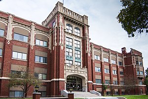
Innovation Central High School
Public school in the United States
Distance: Approx. 693 meters
Latitude and longitude: 42.9658,-85.6585
Innovation Central High School, founded in 1859 as Grand Rapids High School, is a public high school located at 421 Fountain Street NE in Grand Rapids, Michigan. The high school offers classes for grades 9–12. The school colors are Gold and Black, and the school mascot is the Ram.

Grand Rapids, Michigan
City in Michigan, United States
Distance: Approx. 674 meters
Latitude and longitude: 42.96111111,-85.65555556
Grand Rapids is a city in and county seat of Kent County, Michigan, United States. At the 2020 census, the city had a population of 198,893, making it the second-most populous city in Michigan, after Detroit. Grand Rapids is the central city of the Grand Rapids metropolitan area, which has a population of 1,162,950 and a combined statistical area population of 1,502,552.

Kirkhof College of Nursing
College in Michigan, U.S.
Distance: Approx. 1087 meters
Latitude and longitude: 42.97069444,-85.66138889
The Kirkhof College of Nursing is located at Grand Valley State University in Grand Rapids, Michigan, United States.

Third Reformed Church
Historic church in Michigan, United States
Distance: Approx. 690 meters
Latitude and longitude: 42.96111111,-85.64416667
Third Reformed Church (now the Church of God in Christ) is a historic church at 1009 Hermitage St., SE in Grand Rapids, Michigan. It was built in 1875 and added to the National Register in 1982. As of 2019, the church was being rehabilitated into a neighborhood arts center.
West Michigan Grand Prix
Sports event
Distance: Approx. 674 meters
Latitude and longitude: 42.96111111,-85.65555556
The West Michigan Grand Prix was a weekend of professional auto racing held at the Scott Brayton Memorial Street Circuit in Grand Rapids, Michigan. The first edition was held in 1998 and the final edition in 1999. The Grand Prix was sanctioned by SCCA Pro Racing.

Fulton Street Farmers Market
Farmers' market in Grand Rapids, Michigan, USA
Distance: Approx. 831 meters
Latitude and longitude: 42.96277778,-85.64055556
Fulton Street Farmers Market is a farmers market that opened in 1922 in the Grand Rapids, Michigan area.
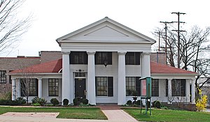
Abram W. Pike House
Historic house in Michigan, United States
Distance: Approx. 1150 meters
Latitude and longitude: 42.96166667,-85.66305556
The Abram W. Pike House is a historic home built in Grand Rapids, Michigan. Built in 1844, it is one of the oldest homes still standing in Michigan and is listed on the National Register of Historic Places. The home is named after its original occupier, Abram W. Pike.

St. Cecilia Music Center
United States historic place
Distance: Approx. 1220 meters
Latitude and longitude: 42.96361111,-85.66472222
The St. Cecilia Music Center, built in 1894 as the St. Cecilia Society Building, is a performance space located at 24 Ransom Avenue NE in Grand Rapids, Michigan.

Paddock Place
United States historic place
Distance: Approx. 857 meters
Latitude and longitude: 42.96,-85.64277778
Paddock Place, also known as the Augustus Paddock House is located at 1033 Lake Drive SE in Grand Rapids, Michigan. It was built as a single-family home and later converted into a banquet and event facility. It was listed on the National Register of Historic Places in 1985.

Willard Building (Grand Rapids, Michigan)
United States historic place
Distance: Approx. 1210 meters
Latitude and longitude: 42.96305556,-85.66444444
The Willard Building, also known as the Peacock Building for the distinctive terra cotta decorative birds spaced at the top of the facades, is a retail building located at 150 East Fulton Street in Grand Rapids, Michigan. It was listed on the National Register of Historic Places in 2013.
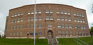
Eastern Avenue School
United States historic place
Distance: Approx. 1235 meters
Latitude and longitude: 42.97666667,-85.64888889
Eastern Avenue School is a former public school building located at 758 Eastern Avenue NE in Grand Rapids, Michigan. It was listed on the National Register of Historic Places in 2013. As of 2018, the current owner plans to convert the building into apartments.
Weather in this IP's area
clear sky
7 Celsius
7 Celsius
6 Celsius
9 Celsius
1032 hPa
81 %
1032 hPa
1005 hPa
10000 meters
08:01:17
18:53:19