Country:
 USA
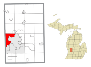
USARegion:
City:
Latitude and Longitude:
Time Zone:
Postal Code:
IP information under different IP Channel
ip-api
Country
Region
City
ASN
Time Zone
ISP
Blacklist
Proxy
Latitude
Longitude
Postal
Route
IPinfo
Country
Region
City
ASN
Time Zone
ISP
Blacklist
Proxy
Latitude
Longitude
Postal
Route
MaxMind
Country
Region
City
ASN
Time Zone
ISP
Blacklist
Proxy
Latitude
Longitude
Postal
Route
Luminati
Country
USRegion
mi
City
grandrapids
ASN
Time Zone
America/Detroit
ISP
123NET
Latitude
Longitude
Postal
db-ip
Country
Region
City
ASN
Time Zone
ISP
Blacklist
Proxy
Latitude
Longitude
Postal
Route
ipdata
Country
Region
City
ASN
Time Zone
ISP
Blacklist
Proxy
Latitude
Longitude
Postal
Route
Popular places and events near this IP address
Walker, Michigan
City in Michigan, United States
Distance: Approx. 2409 meters
Latitude and longitude: 43.01444444,-85.6925
Walker is a city in Kent County in the U.S. state of Michigan. The population was estimated to be 25,086 in 2022. Walker was originally organized as Walker Township in 1837 and later incorporated as a city in 1962.

DeltaPlex Arena
Former sports facility
Distance: Approx. 3315 meters
Latitude and longitude: 43.00861111,-85.68166667
The DeltaPlex Arena & Conference Center (formerly the Stadium Arena and Grand Rapids Stadium) was a 5,500-seat multipurpose arena in Walker, Michigan, United States. It was the home of the Grand Rapids Gold of the NBA G League and the Grand Rapids Wanderers of the Major Arena Soccer League 3. Built in 1952 as The Stadium Arena, the facility was purchased and renovated in the 1990s and was renamed The DeltaPlex Arena & Conference Center in 1998.
WLHT-FM
Radio station in Grand Rapids, Michigan
Distance: Approx. 3096 meters
Latitude and longitude: 43.033,-85.696
WLHT-FM (95.7 MHz) is a hot adult contemporary music formatted radio station in Grand Rapids, Michigan, owned by Townsquare Media. WLHT's studios are located on Ottawa Avenue Northwest in downtown Grand Rapids, while its transmitter is located in Comstock Park. WLHT-FM is also licensed for HD Radio operation, and features WSLI-FM on its HD-2 subchannel.

WFGR
Radio station in Grand Rapids, Michigan
Distance: Approx. 3096 meters
Latitude and longitude: 43.033,-85.696
WFGR (98.7 FM) is an American radio station serving Grand Rapids, Michigan. It transmits from their facility in Alpine Township. WFGR is owned by Townsquare Media.

West Catholic High School
Private school in Grand Rapids, Michigan, United States
Distance: Approx. 2073 meters
Latitude and longitude: 42.99638889,-85.70972222
West Catholic High School is a private Catholic college preparatory secondary school in Grand Rapids, Michigan (U.S.). It is located within the Catholic Diocese of Grand Rapids.
WTKG
Radio station in Grand Rapids, Michigan
Distance: Approx. 4184 meters
Latitude and longitude: 42.995,-85.67666667
WTKG (1230 AM) is a radio station broadcasting a news/talk/sports format consisting of news and sports. Licensed to Grand Rapids, Michigan, United States, and now owned by iHeartMedia, Inc., Previous to adopting the current calls and format in 1997, the station played country under the WJEF (the station on which radio Hall of Famer Wally Phillips started his career) and WCUZ calls.
WTRV
Radio station in Walker–Grand Rapids, Michigan
Distance: Approx. 1510 meters
Latitude and longitude: 43.016,-85.74
WTRV (100.5 FM) is a commercial radio station broadcasting an adult contemporary radio format. The station is licensed to Walker, Michigan, and serves the Grand Rapids metropolitan area radio market. WTRV is a Class A station, so it is limited to 3,000 watts.
Kenowa Hills Public Schools
Public school
Distance: Approx. 2021 meters
Latitude and longitude: 43.030479,-85.727037
Kenowa Hills Public Schools is a school district headquartered in Alpine Township, Michigan in Greater Grand Rapids. It serves portions of Alpine Township, the City of Walker, and Wright Township (including Marne).

Kenowa Hills High School
Public secondary school in Grand Rapids, Michigan, United States
Distance: Approx. 3181 meters
Latitude and longitude: 43.032823,-85.74975
Kenowa Hills High School is a public secondary school in Alpine Township, Michigan, U.S. (near Grand Rapids). It serves grades 9-12 for the Kenowa Hills Public Schools district.

Villa Maria (Grand Rapids, Michigan)
United States historic place
Distance: Approx. 3679 meters
Latitude and longitude: 42.98361111,-85.70055556
Villa Maria is a retirement community located at 1315 Walker NW in Grand Rapids, Michigan. The campus was originally operated for the purpose of ministering to troubled young women. It was listed on the National Register of Historic Places in 1987.
Ahavas Israel Cemetery
Distance: Approx. 2589 meters
Latitude and longitude: 42.99627137,-85.69949495
Ahavas Israel Cemetery is located at 1801 Garfield Avenue in Grand Rapids, Michigan. It is the cemetery for the Conservative Ahavas Israel congregation. The Ahavas Achim Cemetery was created in 1916 by members of the Ahavas Achim and the Workmen's Circle.

Irving Andrew and Olive Crane Kendall Dean House
United States historic place
Distance: Approx. 3043 meters
Latitude and longitude: 42.98555556,-85.72638889
The Irving Andrew and Olive Crane Kendall Dean House, also known as Mayflower Place, is a single family home located at 2350 Leonard Street NW in Grand Rapids, Michigan. It was listed on the National Register of Historic Places in 2023.
Weather in this IP's area
clear sky
7 Celsius
5 Celsius
6 Celsius
9 Celsius
1032 hPa
82 %
1032 hPa
1005 hPa
10000 meters
2.82 m/s
3.61 m/s
178 degree
08:01:38
18:53:32