Country:
 USA
USARegion:
City:
Latitude and Longitude:
Time Zone:
Postal Code:
IP information under different IP Channel
ip-api
Country
Region
City
ASN
Time Zone
ISP
Blacklist
Proxy
Latitude
Longitude
Postal
Route
IPinfo
Country
Region
City
ASN
Time Zone
ISP
Blacklist
Proxy
Latitude
Longitude
Postal
Route
MaxMind
Country
Region
City
ASN
Time Zone
ISP
Blacklist
Proxy
Latitude
Longitude
Postal
Route
Luminati
Country
USRegion
mi
City
nashville
ASN
Time Zone
America/Detroit
ISP
123NET
Latitude
Longitude
Postal
db-ip
Country
Region
City
ASN
Time Zone
ISP
Blacklist
Proxy
Latitude
Longitude
Postal
Route
ipdata
Country
Region
City
ASN
Time Zone
ISP
Blacklist
Proxy
Latitude
Longitude
Postal
Route
Popular places and events near this IP address
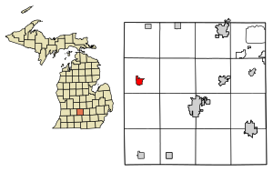
Castleton Township, Michigan
Township in Michigan, United States
Distance: Approx. 2870 meters
Latitude and longitude: 42.62277778,-85.12527778
Castleton Township is a civil township of Barry County in the U.S. state of Michigan. The population was 3,329 at the 2020 census. Castleton Township was formed on February 16, 1842.
Maple Grove Township, Barry County, Michigan
Township in Michigan, United States
Distance: Approx. 5059 meters
Latitude and longitude: 42.55222222,-85.13194444
Maple Grove Township is a civil township of Barry County in the U.S. state of Michigan. The population was 1,599 at the 2020 census. The unincorporated community of Maple Grove is located within the township.

Nashville, Michigan
Village in Michigan, United States
Distance: Approx. 2470 meters
Latitude and longitude: 42.60277778,-85.09305556
Nashville is a village in Barry County in the U.S. state of Michigan. The population was 1,537 at the 2020 census. The township exists largely within Castleton Township, with a small portion extending south into Maple Grove Township.
Vermontville, Michigan
Village in Michigan, United States
Distance: Approx. 8734 meters
Latitude and longitude: 42.62694444,-85.02361111
Vermontville is a village in Eaton County in the U.S. state of Michigan. The population was 759 at the 2010 census. It is located within Vermontville Township.
Vermontville Township, Michigan
Township in Michigan, United States
Distance: Approx. 9842 meters
Latitude and longitude: 42.63222222,-85.01194444
Vermontville Township is a civil township of Eaton County in the U.S. state of Michigan. The population was 1,947 at the 2020 census.
Maple Valley Schools
School district in Michigan
Distance: Approx. 5689 meters
Latitude and longitude: 42.61172222,-85.05566667
Maple Valley Schools (Vermontville-Maple Valley) is located in Vermontville, Eaton County, Michigan. Maple Valley Schools is within the Eaton Intermediate School District.
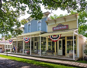
Historic Charlton Park
Distance: Approx. 7157 meters
Latitude and longitude: 42.621,-85.2033
Historic Charlton Park is a historically oriented local facility and museum in Barry County, Michigan, that sits on 310 acres (1.3 km2) along the Thornapple River. The village is made up of a number of nineteenth and early-twentieth century structures that have been brought together from around the county to recreate a Michigan village from the turn of the 20th century. Buildings include a lawyer's home, blacksmith shop, bank and insurance office, barber shop, inn and stagecoach stop, Church, carpenter/cooper shop, carriage house, general store, hardware store, school, printshop, cabin, sawmill, and the Hastings Township Hall.

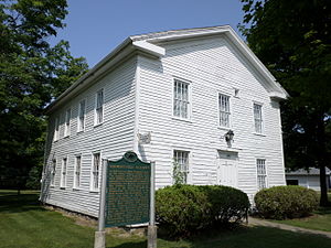
First Congregational Church (Vermontville, Michigan)
Historic church in Michigan, United States
Distance: Approx. 8706 meters
Latitude and longitude: 42.62916667,-85.02527778
The First Congregational Church is a historic church located at 110 S. Main Street in Vermontville, Michigan. It was built in 1862 and added to the National Register of Historic Places in 1971, and is part of the Historic American Buildings Survey.
Vermontville Chapel and Academy
United States historic place
Distance: Approx. 8744 meters
Latitude and longitude: 42.63,-85.02527778
The Vermontville Academy, also known as the First Congregational Chapel, is a building in Vermontville, Michigan, located at 106 North Main Street. It was listed on the National Register of Historic Places in 1972, and is part of the Historic American Buildings Survey. It now serves as the Vermontville Historical Museum.
Weather in this IP's area
clear sky
7 Celsius
5 Celsius
7 Celsius
9 Celsius
1021 hPa
85 %
1021 hPa
987 hPa
10000 meters
3.36 m/s
8.32 m/s
244 degree
6 %
07:13:31
20:02:49