152.156.98.99 - IP Lookup: Free IP Address Lookup, Postal Code Lookup, IP Location Lookup, IP ASN, Public IP
Country:
Region:
City:
Location:
Time Zone:
Postal Code:
ISP:
ASN:
language:
User-Agent:
Proxy IP:
Blacklist:
IP information under different IP Channel
ip-api
Country
Region
City
ASN
Time Zone
ISP
Blacklist
Proxy
Latitude
Longitude
Postal
Route
db-ip
Country
Region
City
ASN
Time Zone
ISP
Blacklist
Proxy
Latitude
Longitude
Postal
Route
IPinfo
Country
Region
City
ASN
Time Zone
ISP
Blacklist
Proxy
Latitude
Longitude
Postal
Route
IP2Location
152.156.98.99Country
Region
canelones
City
atlantida
Time Zone
America/Montevideo
ISP
Language
User-Agent
Latitude
Longitude
Postal
ipdata
Country
Region
City
ASN
Time Zone
ISP
Blacklist
Proxy
Latitude
Longitude
Postal
Route
Popular places and events near this IP address
La Floresta, Uruguay
City in Canelones Department, Uruguay
Distance: Approx. 7782 meters
Latitude and longitude: -34.755,-55.67583333
La Floresta is a city and resort on the Costa de Oro (Coast of Gold) of the Canelones Department in Uruguay. La Floresta is also the name of the municipality to which the city belongs and includes several more resorts of the Costa de Oro, east of La Floresta and up to the border with Maldonado Department.

Estación Atlántida
Suburb of Atlántida in Canelones Department, Uruguay
Distance: Approx. 2552 meters
Latitude and longitude: -34.75,-55.76666667
Estación Atlántida is a northern suburb of the city Atlántida in the Canelones Department of southern Uruguay.
Las Toscas, Canelones
Resort of the Costa de Oro in Canelones Department, Uruguay
Distance: Approx. 2365 meters
Latitude and longitude: -34.76666667,-55.73333333
Las Toscas is a resort of the Costa de Oro in the Canelones Department of southern Uruguay.

Marindia
Resort of the Costa de Oro in Canelones Department, Uruguay
Distance: Approx. 5964 meters
Latitude and longitude: -34.77083333,-55.82361111
Marindia is a resort of the Costa de Oro in the Canelones Department of southern Uruguay.

Parque del Plata
City in Canelones, Uruguay
Distance: Approx. 3860 meters
Latitude and longitude: -34.76666667,-55.71666667
Parque del Plata is a city of the Costa de Oro in the Canelones Department of southern Uruguay.

Salinas, Uruguay
City & Municipality in Canelones, Uruguay
Distance: Approx. 6969 meters
Latitude and longitude: -34.78333333,-55.83333333
Salinas is a city and resort of the Costa de Oro in the Canelones Department of southern Uruguay. Salinas is also the name of the municipality to which the town belongs and which includes the resort towns Marindia, Pinamar–Pinepark, Neptunia and rural areas to their north.

Villa Argentina
Resort of the Costa de Oro in Canelones Department, Uruguay
Distance: Approx. 2353 meters
Latitude and longitude: -34.76666667,-55.78333333
Villa Argentina is a resort (balneario) of the Costa de Oro in the Canelones Department of southern Uruguay. The famous eagle-shaped house overlooking the Río de la Plata, which is attributed to Atlántida, is in fact located in this resort.

Estación La Floresta
Suburb of La Floresta in Canelones Department, Uruguay
Distance: Approx. 7719 meters
Latitude and longitude: -34.73611111,-55.68611111
Estación La Floresta is a suburb of La Floresta in the Canelones Department of Uruguay.
Pinamar – Pinepark
Resort of the Costa de Oro in Canelones Department, Uruguay
Distance: Approx. 8931 meters
Latitude and longitude: -34.7775,-55.85583333
Pinamar – Pinepark is a resort town of the Costa de Oro in the Canelones Department of southern Uruguay.

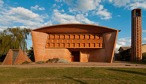
Iglesia de Cristo Obrero y Nuestra Señora de Lourdes
Roman Catholic parish church and World Heritage Site in Estación Atlántida, Uruguay
Distance: Approx. 3199 meters
Latitude and longitude: -34.74392,-55.7664
The Church of Christ the Worker and Our Lady of Lourdes (Spanish: Iglesia de Cristo Obrero y Nuestra Señora de Lourdes), also known simply as Iglesia de Estación Atlántida, is a Roman Catholic parish church and a World Heritage Site in Estación Atlántida, Uruguay.

Solís Chico Creek
River in Uruguay
Distance: Approx. 2365 meters
Latitude and longitude: -34.76666667,-55.73333333
Solís Chico Creek is a Uruguayan stream, crossing Canelones Department. It flows into the Río de la Plata, between Parque del Plata and Las Vegas. It is named after Spanish explorer Juan Díaz de Solís.

Laguna del Cisne
Lake in Uruguay
Distance: Approx. 6459 meters
Latitude and longitude: -34.74611111,-55.82166667
The Laguna del Cisne is a subtropical body of water located near Salinas, in the department of Canelones, in Uruguay. The surface area is 1,8 km², the watershed feeding the lake includes about 50 km². The laguna feeds the Tropa Vieja River, which in turn feeds the Arroyo Pando, which terminates in the Río de la Plata.
Weather in this IP's area
clear sky
23 Celsius
24 Celsius
23 Celsius
23 Celsius
1014 hPa
94 %
1014 hPa
1012 hPa
10000 meters
3.66 m/s
4.94 m/s
94 degree