152.156.177.136 - IP Lookup: Free IP Address Lookup, Postal Code Lookup, IP Location Lookup, IP ASN, Public IP
Country:
Region:
City:
Location:
Time Zone:
Postal Code:
ISP:
ASN:
language:
User-Agent:
Proxy IP:
Blacklist:
IP information under different IP Channel
ip-api
Country
Region
City
ASN
Time Zone
ISP
Blacklist
Proxy
Latitude
Longitude
Postal
Route
db-ip
Country
Region
City
ASN
Time Zone
ISP
Blacklist
Proxy
Latitude
Longitude
Postal
Route
IPinfo
Country
Region
City
ASN
Time Zone
ISP
Blacklist
Proxy
Latitude
Longitude
Postal
Route
IP2Location
152.156.177.136Country
Region
canelones
City
pando
Time Zone
America/Montevideo
ISP
Language
User-Agent
Latitude
Longitude
Postal
ipdata
Country
Region
City
ASN
Time Zone
ISP
Blacklist
Proxy
Latitude
Longitude
Postal
Route
Popular places and events near this IP address

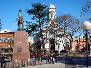
Pando, Uruguay
City & Municipality in Canelones, Uruguay
Distance: Approx. 763 meters
Latitude and longitude: -34.71666667,-55.95833333
Pando is a city in the Canelones Department of Uruguay. It is an important commercial and industrial centre which has become part of the wider Montevideo metropolitan area. Pando is also the name of the municipality to which the city belongs and which includes several other small populated areas and rural areas from the limits of the Ciudad de la Costa to the south to the limits of Route 7 to the northwest.
Barros Blancos
City in Canelones, Uruguay
Distance: Approx. 6477 meters
Latitude and longitude: -34.75416667,-56.00416667
Barros Blancos is a city in the Canelones Department of southern Uruguay. In 1976, it had been renamed to Juan Antonio Artigas, after commanding officer Juan Antonio Artigas, grandfather of the national hero José Gervasio Artigas, but the old name was reinstated in 2007. Barros Blancos is also the name of the municipality to which the city belongs and which includes the two fragments of Camino Maldonado and some surrounding rural areas.

Joaquín Suárez (town)
Village in Canelones Department, Uruguay
Distance: Approx. 7846 meters
Latitude and longitude: -34.73333333,-56.03333333
Joaquín Suárez is a village in the Canelones Department of southern Uruguay. (Suárez is also the name of the municipality to which the village belongs.) It is at the intersection of Routes 84 and 74, northeast of Toledo and southwest of Pando. Sauce is about 10 kilometres (6.2 mi) to the north.

Empalme Olmos
Village in Canelones Department, Uruguay
Distance: Approx. 4939 meters
Latitude and longitude: -34.7,-55.9
Empalme Olmos is a village in the Canelones Department of southern Uruguay. Empalme Olmos is also the name of the municipality to which the town belongs.
Estanque de Pando
Suburb of Pando in Canelones Department, Uruguay
Distance: Approx. 2405 meters
Latitude and longitude: -34.7,-55.96666667
Estanque de Pando is a northern suburb of Pando in the Canelones Department of southern Uruguay.
Jardines de Pando
Suburb of Pando in Canelones Department, Uruguay
Distance: Approx. 4015 meters
Latitude and longitude: -34.68333333,-55.96666667
Jardines de Pando is a suburb of the city of Pando in the Canelones Department of southern Uruguay.
Totoral del Sauce
Village in Canelones Department, Uruguay
Distance: Approx. 7209 meters
Latitude and longitude: -34.66666667,-56
Totoral del Sauce is a village or populated centre in the Canelones Department of southern Uruguay.
Villa El Tato
Urban fragment in Canelones Department, Uruguay
Distance: Approx. 6840 meters
Latitude and longitude: -34.775,-55.97361111
Villa El Tato is a subdivision founded in 1900 in the department of Canelones, in southern Uruguay. It is part of the metropolitan area of Montevideo.
Fraccionamiento Camino Maldonado
Suburb of Pando in Canelones Department, Uruguay
Distance: Approx. 3366 meters
Latitude and longitude: -34.73888889,-55.975
Fraccionamiento Camino Maldonado is a suburb of Pando. It is composed of two fragments, one at the northeast and one at the southwest of Barros Blancos. The three together form a southwestern extension of the urban area of Pando, and they all belong to the wider metropolitan area of Montevideo.
Olmos, Uruguay
Populated centre in Canelones Department, Uruguay
Distance: Approx. 2738 meters
Latitude and longitude: -34.69861111,-55.92972222
Olmos is a populated centre in the Canelones Department of southern Uruguay.
Lomas de La Tahona
Residential area in Canelones Department, Uruguay
Distance: Approx. 7990 meters
Latitude and longitude: -34.78611111,-55.97222222
Lomas de La Tahona is a residential area in the Canelones Department of southern Uruguay.

Autódromo Víctor Borrat Fabini
Motorsport racetrack in Uruguay
Distance: Approx. 7549 meters
Latitude and longitude: -34.78055556,-55.92222222
Autodromo Víctor Borrat Fabini is a motor racing circuit in El Pinar, Uruguay, located 31 km (19 mi) from Montevideo. It was inaugurated on 14 October 1956. The circuit features various layout configurations.
Weather in this IP's area
broken clouds
25 Celsius
26 Celsius
25 Celsius
25 Celsius
1012 hPa
94 %
1012 hPa
1009 hPa
10000 meters
5.66 m/s
130 degree
75 %
