152.156.115.96 - IP Lookup: Free IP Address Lookup, Postal Code Lookup, IP Location Lookup, IP ASN, Public IP
Country:
 Uruguay
Region:
City:
Location:
Time Zone:
Postal Code:
ISP:
ASN:
language:
User-Agent:
Proxy IP:
Blacklist:
IP information under different IP Channel
ip-api
Country
Region
City
ASN
Time Zone
ISP
Blacklist
Proxy
Latitude
Longitude
Postal
Route
db-ip
Country
Region
City
ASN
Time Zone
ISP
Blacklist
Proxy
Latitude
Longitude
Postal
Route
IPinfo
Country
Region
City
ASN
Time Zone
ISP
Blacklist
Proxy
Latitude
Longitude
Postal
Route
IP2Location
152.156.115.96Country
uyRegion
canelones
City
salinas
Time Zone
America/Montevideo
ISP
Language
User-Agent
Latitude
Longitude
Postal
ipdata
Country
Region
City
ASN
Time Zone
ISP
Blacklist
Proxy
Latitude
Longitude
Postal
Route
Popular places and events near this IP address
El Pinar, Uruguay
Resort of Ciudad de la Costa in Canelones Department, Uruguay
Distance: Approx. 6792 meters
Latitude and longitude: -34.79722222,-55.90972222
El Pinar is a seaside resort of the Canelones Department, Uruguay. In 1994, when Ciudad de la Costa took on the status of a city, El Pinar was incorporated in it.

Estación Atlántida
Suburb of Atlántida in Canelones Department, Uruguay
Distance: Approx. 7321 meters
Latitude and longitude: -34.75,-55.76666667
Estación Atlántida is a northern suburb of the city Atlántida in the Canelones Department of southern Uruguay.

Las Toscas, Canelones
Resort of the Costa de Oro in Canelones Department, Uruguay
Distance: Approx. 9780 meters
Latitude and longitude: -34.76666667,-55.73333333
Las Toscas is a resort of the Costa de Oro in the Canelones Department of southern Uruguay.

Marindia
Resort of the Costa de Oro in Canelones Department, Uruguay
Distance: Approx. 1621 meters
Latitude and longitude: -34.77083333,-55.82361111
Marindia is a resort of the Costa de Oro in the Canelones Department of southern Uruguay.

Neptunia, Uruguay
Resort of the Costa de Oro in Canelones Department, Uruguay
Distance: Approx. 2573 meters
Latitude and longitude: -34.78333333,-55.86666667
Neptunia is a resort town of the Costa de Oro in the Canelones Department of southern Uruguay.

Salinas, Uruguay
City & Municipality in Canelones, Uruguay
Distance: Approx. 877 meters
Latitude and longitude: -34.78333333,-55.83333333
Salinas is a city and resort of the Costa de Oro in the Canelones Department of southern Uruguay. Salinas is also the name of the municipality to which the town belongs and which includes the resort towns Marindia, Pinamar–Pinepark, Neptunia and rural areas to their north.

Villa Argentina
Resort of the Costa de Oro in Canelones Department, Uruguay
Distance: Approx. 5271 meters
Latitude and longitude: -34.76666667,-55.78333333
Villa Argentina is a resort (balneario) of the Costa de Oro in the Canelones Department of southern Uruguay. The famous eagle-shaped house overlooking the Río de la Plata, which is attributed to Atlántida, is in fact located in this resort.
Pinamar – Pinepark
Resort of the Costa de Oro in Canelones Department, Uruguay
Distance: Approx. 1494 meters
Latitude and longitude: -34.7775,-55.85583333
Pinamar – Pinepark is a resort town of the Costa de Oro in the Canelones Department of southern Uruguay.
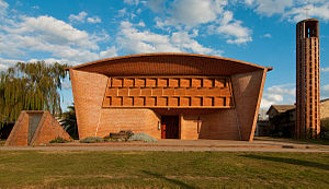
Iglesia de Cristo Obrero y Nuestra Señora de Lourdes
Roman Catholic parish church and World Heritage Site in Estación Atlántida, Uruguay
Distance: Approx. 7649 meters
Latitude and longitude: -34.74392,-55.7664
The Church of Christ the Worker and Our Lady of Lourdes (Spanish: Iglesia de Cristo Obrero y Nuestra Señora de Lourdes), also known simply as Iglesia de Estación Atlántida, is a Roman Catholic parish church and a World Heritage Site in Estación Atlántida, Uruguay.
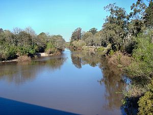
Pando Creek
River in Uruguay
Distance: Approx. 3543 meters
Latitude and longitude: -34.8,-55.86666667
Pando Creek (Spanish: Arroyo Pando) is a Uruguayan stream, crossing Canelones Department. It flows into the Río de la Plata. Its name derives from the nearby city of Pando.

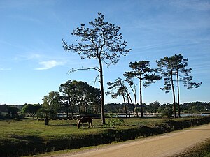
Autódromo Víctor Borrat Fabini
Motorsport racetrack in Uruguay
Distance: Approx. 7572 meters
Latitude and longitude: -34.78055556,-55.92222222
Autodromo Víctor Borrat Fabini is a motor racing circuit in El Pinar, Uruguay, located 31 km (19 mi) from Montevideo. It was inaugurated on 14 October 1956. The circuit features various layout configurations.

Laguna del Cisne
Lake in Uruguay
Distance: Approx. 3836 meters
Latitude and longitude: -34.74611111,-55.82166667
The Laguna del Cisne is a subtropical body of water located near Salinas, in the department of Canelones, in Uruguay. The surface area is 1,8 km², the watershed feeding the lake includes about 50 km². The laguna feeds the Tropa Vieja River, which in turn feeds the Arroyo Pando, which terminates in the Río de la Plata.
Weather in this IP's area
clear sky
26 Celsius
26 Celsius
26 Celsius
27 Celsius
1007 hPa
73 %
1007 hPa
1005 hPa
10000 meters
3.6 m/s
50 degree