Country:
 Denmark
Region:
City:
Latitude and Longitude:
Time Zone:
Postal Code:
IP information under different IP Channel
ip-api
Country
Region
City
ASN
Time Zone
ISP
Blacklist
Proxy
Latitude
Longitude
Postal
Route
IPinfo
Country
Region
City
ASN
Time Zone
ISP
Blacklist
Proxy
Latitude
Longitude
Postal
Route
MaxMind
Country
Region
City
ASN
Time Zone
ISP
Blacklist
Proxy
Latitude
Longitude
Postal
Route
Luminati
Country
DKRegion
84
City
copenhagen
ASN
Time Zone
Europe/Copenhagen
ISP
GlobalConnect A/S
Latitude
Longitude
Postal
db-ip
Country
Region
City
ASN
Time Zone
ISP
Blacklist
Proxy
Latitude
Longitude
Postal
Route
ipdata
Country
Region
City
ASN
Time Zone
ISP
Blacklist
Proxy
Latitude
Longitude
Postal
Route
Popular places and events near this IP address

Rosenborg Castle Gardens
Park in Copenhagen, Denmark
Distance: Approx. 146 meters
Latitude and longitude: 55.685,12.579
Rosenborg Castle Gardens (Danish: Kongens Have; literally The King's Garden) is the oldest and most visited park in central Copenhagen, Denmark. Established in the early 17th century as the private gardens of King Christian IV's Rosenborg Castle, the park also contains several other historical buildings, including Rosenborg Barracks, home to the Royal Guards, as well as a high number of statues and monuments. The park also holds art exhibitions and other events such as concerts in the summer.

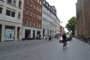
Gothersgade
Street in Copenhagen, Denmark
Distance: Approx. 131 meters
Latitude and longitude: 55.685,12.57638889
Gothersgade (Danish pronunciation: [ˈkoˀtɐsˌkɛːðə]; see below) is a major street in the City Centre of Copenhagen, Denmark. It extends from Kongens Nytorv to Sortedam Lake, passing Rosenborg Castle and Gardens, Nørreport Station and Copenhagen Botanic Gardens on the way. Every day at 11:30 am, the Royal Life Guards, who are based at Rosenborg Barracks, depart from Rosenborg Eksercerplads and march down Gothersgade and up Bredgade for the ceremonial changing of the guard at 12 noon at Amalienborg Palace Square.

Reformed Church, Copenhagen
Church in Copenhagen, Denmark
Distance: Approx. 152 meters
Latitude and longitude: 55.68376944,12.57510556
Reformed Church (Danish: Reformert Kirke) in Gothersgade, opposite Rosenborg Castle, is a church building used by the reformed congregations in Copenhagen, Denmark. Consecrated in 1689, the church was instigated by Queen Charlotte Amalie, consort of King Christian V, who was herself a German Calvinist. The church is noted for its fine Baroque interiors which date from 1730 when it was restored after being damaged in the Copenhagen Fire of 1728.

Københavns Belysningsvæsen
Distance: Approx. 171 meters
Latitude and longitude: 55.6828,12.5792
Københavns Belysningsvæsen was a municipally owned company which supplied Copenhagen Tårnby and Dragør municipalities with first gas and later electricity and distant heating, It existed until 2001 when it was merged with Københavns Vand under the name Københavns Energi, a name it had already operated under since 1999. Its former headquarters is located on Gothersgade in central Copenhagen and now houses Københavns VUC, a school of secondary education.
Landemærket
Distance: Approx. 170 meters
Latitude and longitude: 55.6825,12.577
Landemærket, literally "The Landmark", is a street in the Old Town of Copenhagen, Denmark. It extends from Købmagergade along the north side of the Trinitatis Complex (Round Tower and Trinitatis Church, Guttenberghus and the Film House to Gothersgade at Rosenborg Castle Gardens.
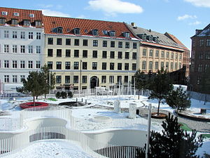
Hauser Plads
Distance: Approx. 134 meters
Latitude and longitude: 55.6832,12.5759
Hauser Plads is a public square in the Old Town of Copenhagen, Denmark. It is separated from the larger, more well-known square Kultorvet by the former Copenhagen Central Library Building. A landscaped playground and Copenhagen Municipality's underground Cleaning Facilities Centre occupies most of the site since a renovation in 2011..

Åbenrå (street)
Street in Copenhagen, Denmark
Distance: Approx. 116 meters
Latitude and longitude: 55.683,12.577
Åbenrå is a street in the Old Town of Copenhagen, Denmark. It runs from Landemærket in the southeast to Rosenborggade in the northwest, linking Vognmagergade with Tornebuskgade. The last part of the street passes the rear side of the grounds of the Reformed Church in Gothersgade.

Suhmsgade
Distance: Approx. 160 meters
Latitude and longitude: 55.6828,12.5761
Suhmsgade is a street in the Old Town of Copenhagen, Denmark. It runs from Landemærket to Hauser Plads.
Åbenrå 25
Distance: Approx. 134 meters
Latitude and longitude: 55.68333056,12.57571944
Åbenrå 25 is an 18th-century town house located at Åbenrå 25 in the Old Town of Copenhagen, Denmark. It was listed in the Danish registry of protected buildings and places in 1945.

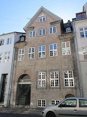
Åbenrå 26
18th-century building in Copenhagen
Distance: Approx. 107 meters
Latitude and longitude: 55.68333056,12.57626944
Åbenrå 26 is an 18th-century property situated at Åbenrå 26 in the Old Town of Copenhagen, Denmark. It was listed in the Danish registry of protected buildings and places in 1964.

Hauser Plads 24
Listed building in Copenhagen
Distance: Approx. 143 meters
Latitude and longitude: 55.68313889,12.57581944
Hauser Plads 24/Pbenrå 23 is an 18th-century building complex occupying an irregular corner site between the square Hauser Plads and the street Åbenrå, north of a short unnamed street section linking the square with the street, in the Old Town of Copenhagen, Denmark. It is the only building on the square that dates from the time before the British bombardment in 1807 and the subsequent creation of the square. It was listed in the Danish registry of protected buildings and places in 1945.

Hauser Plads 16
Listed building in Copenhagen
Distance: Approx. 165 meters
Latitude and longitude: 55.68273889,12.57611111
Hauser Plads 16 is an 11-bays-wide, mid 19th-century building situated on the east side of Hauser Plads in the Old Town of Copenhagen, Denmark. The building was listed in the Danish registry of protected buildings and places in 1945. Notable former residents include writer and educator Harald Valdemar Rasmussen (1821–1891) and painter Julius Exner.
Weather in this IP's area
overcast clouds
12 Celsius
12 Celsius
11 Celsius
12 Celsius
1005 hPa
95 %
1005 hPa
1004 hPa
10000 meters
3.3 m/s
6.12 m/s
174 degree
100 %
07:24:40
18:29:56