Country:
 Denmark
Region:
City:
Latitude and Longitude:
Time Zone:
Postal Code:
IP information under different IP Channel
ip-api
Country
Region
City
ASN
Time Zone
ISP
Blacklist
Proxy
Latitude
Longitude
Postal
Route
IPinfo
Country
Region
City
ASN
Time Zone
ISP
Blacklist
Proxy
Latitude
Longitude
Postal
Route
MaxMind
Country
Region
City
ASN
Time Zone
ISP
Blacklist
Proxy
Latitude
Longitude
Postal
Route
Luminati
Country
DKRegion
84
City
copenhagen
ASN
Time Zone
Europe/Copenhagen
ISP
GlobalConnect A/S
Latitude
Longitude
Postal
db-ip
Country
Region
City
ASN
Time Zone
ISP
Blacklist
Proxy
Latitude
Longitude
Postal
Route
ipdata
Country
Region
City
ASN
Time Zone
ISP
Blacklist
Proxy
Latitude
Longitude
Postal
Route
Popular places and events near this IP address
Fremad Amager
Football club
Distance: Approx. 246 meters
Latitude and longitude: 55.64638889,12.59916667
Boldklubben Fremad Amager (meaning in English: The Ball Club Forward Amager ; abbreviated Fremad A) is a Danish professional football club based in the district of Amager Vest, Copenhagen. As of the 2024–25 season, the club's senior men's team play in 2nd Division, the third tier in the Danish football league system. The club have primarily played their home games at Sundby Idrætspark since the stadium's inauguration in 1922.
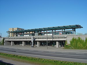
Sundby station
Copenhagen metro station
Distance: Approx. 1037 meters
Latitude and longitude: 55.64522222,12.58575
Sundby station is a rapid transit station on the Copenhagen Metro. It is served by the M1 line. The station is elevated from ground level and opened on 19 October 2002.

Sundby Idrætspark
Distance: Approx. 210 meters
Latitude and longitude: 55.650044,12.602123
Sundby Idrætspark is a sports complex, that consists of a combined association football and athletics stadium, located in the district of Amager Vest, Copenhagen. It is the home ground of the association football clubs BK Fremad Amager, B 1908 and Sundby Boldklub, hosting the first senior women's team of Sundby BK in the seasons 2021–22 and 2022–23, and have previously hosted BK Standard (1923–1946) and the professional superstructure FC Amager (2008–2009). As of May 2019, the total capacity of approximately 7,200 spectators, with 2,500 seatings at the main grand stand stretching along one side of the pitch, makes the exhibition field among the 25th largest football stadiums in Denmark.

Royal School of Library and Information Science
Ella.Com
Distance: Approx. 910 meters
Latitude and longitude: 55.65624167,12.59878611
The Royal School of Library and Information Science (abbr. RSLIS, Danish: Det Informationsvidenskabelige Akademi) is a school under the University of Copenhagen that provides higher education in the field of library and information science. It has now merged with another department to Department of Communication.

Grønjordskollegiet
Distance: Approx. 914 meters
Latitude and longitude: 55.65430556,12.59166667
Grønjordskollegiet is a dormitory situated on Amager, Copenhagen, up to natural area Amager Fælled by Grønjordssøen. The dormitory is one of Denmark's largest with 920 rooms and approx. 1000 residents.
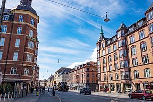
Amagerbrogade
Shopping street in Amager, Copenhagen, Denmark
Distance: Approx. 729 meters
Latitude and longitude: 55.65055556,12.61222222
Amagerbrogade is the main shopping street and thoroughfare of the part of Copenhagen, Denmark that is located on the island of Amager. It begins at the end of the causeway which connects Amager to Christianshavn and the city centre on the other side of the harbour, and runs south until it reaches the municipal border with Tårnby where it continues as Amager Landevej. The street marks the border between Amager Vest and Amager Øst, two of the ten official districts of Copenhagen.

Eberts Villaby
Distance: Approx. 931 meters
Latitude and longitude: 55.6556,12.6083
Eberts Villaby (literally "Ebert's Villa Town") is an enclave of late 19th-century detached houses situated just off Amagerbrogade in the otherwise more dense Sundby district on Amager in Copenhagen, Denmark.

Sundby, Copenhagen
Distance: Approx. 980 meters
Latitude and longitude: 55.65,12.61666667
Sundby is a neighbourhood on Amager in Copenhagen, Denmark. It is often also referred to as Sundbyerne (plural form) since a distinction is traditionally made between Sundbyvester (Sundby West) and Sundbyøster (Sundby East), located on each their side of Amagerbrogade.

St. Anne's Church, Copenhagen
Church in Copenhagen, Denmark
Distance: Approx. 901 meters
Latitude and longitude: 55.655,12.60916667
St. Anne's Church (Danish: Sankt Annæ Kirke) is a Roman-Catholic church in Sundby on Amager in Copenhagen, Denmark. It is located just off Amagerbrogade, next to Eberts Villaby.

St. Elisabeth's Hospital, Copenhagen
Hospital in Copenhagen, Denmark
Distance: Approx. 874 meters
Latitude and longitude: 55.6547,12.6092
St. Elizabeth's Hospital (Danish: Sankt Elisabeths Hospital) was a Catholic hospital on Amager in Copenhagen, Denmark, which existed from 1905 until 1997 when it was merged with Sundby Hospital to form Amager Hospital. Its old main building on Hans Bogbinders Allé, opposite the Catholic St.

Højdevang Church
Church in Copenhagen, Denmark
Distance: Approx. 237 meters
Latitude and longitude: 55.6478,12.6051
Højdevang Church (Højdevangskirken) is a church in the Amager area of Copenhagen, Denmark. The church was consecrated on 14 April 1935. It was built on the basis of designs by architect Poul Staffeldt Mathiesen (1891–1979) .

Solvang Church
Church in Copenhagen, Denmark
Distance: Approx. 414 meters
Latitude and longitude: 55.6488,12.5949
Solvang Church (Solvang Kirke) is a church in the Amager district of Copenhagen, Denmark. It was built between 1975 and 1976 on designs of architect Holger Jensen. It consists of a complex of box-shaped buildings, which also includes a parish hall and a confirmation halls.
Weather in this IP's area
overcast clouds
18 Celsius
18 Celsius
17 Celsius
19 Celsius
1013 hPa
93 %
1013 hPa
1012 hPa
10000 meters
3.09 m/s
80 degree
100 %
06:28:44
19:46:01