Country:
 Denmark
Region:
City:
Latitude and Longitude:
Time Zone:
Postal Code:
IP information under different IP Channel
ip-api
Country
Region
City
ASN
Time Zone
ISP
Blacklist
Proxy
Latitude
Longitude
Postal
Route
IPinfo
Country
Region
City
ASN
Time Zone
ISP
Blacklist
Proxy
Latitude
Longitude
Postal
Route
MaxMind
Country
Region
City
ASN
Time Zone
ISP
Blacklist
Proxy
Latitude
Longitude
Postal
Route
Luminati
Country
DKRegion
84
City
copenhagen
ASN
Time Zone
Europe/Copenhagen
ISP
GlobalConnect A/S
Latitude
Longitude
Postal
db-ip
Country
Region
City
ASN
Time Zone
ISP
Blacklist
Proxy
Latitude
Longitude
Postal
Route
ipdata
Country
Region
City
ASN
Time Zone
ISP
Blacklist
Proxy
Latitude
Longitude
Postal
Route
Popular places and events near this IP address

Bispebjerg
District in Copenhagen, Denmark
Distance: Approx. 1231 meters
Latitude and longitude: 55.70833333,12.53333333
Bispebjerg, more commonly referred to as Nordvest (English: North-West), is one of the 10 official districts of Copenhagen Municipality, Denmark. Located on the northern border of the municipality, it covers an area of 5.39 km² and a population of 40,033. More specifically, Bispebjerg refers to a smaller neighbourhood within the district, located on the Bispebjerg Hill from which it takes its name.

Carlstad
Fortified town in Denmark
Distance: Approx. 1430 meters
Latitude and longitude: 55.70361111,12.50416667
Carlstad was a short lived fortified town in Denmark built by the forces of King Charles X Gustav of Sweden during his assault on Copenhagen (1659). At its peak, Carlstad's size rivalled the besieged Danish capital, reaching a peak of approx. 30,000 inhabitants.
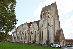
Grundtvig's Church
Church in Copenhagen, Denmark
Distance: Approx. 1084 meters
Latitude and longitude: 55.71658333,12.53361111
Grundtvig's Church (Danish: Grundtvigs Kirke) is located in the Bispebjerg district of Copenhagen, Denmark. It is a rare example of expressionist church architecture. Due to its originality, it is one of the best known churches in the city.

Bellahøj
Distance: Approx. 1010 meters
Latitude and longitude: 55.70555556,12.5125
Bellahøj is an area situated 5 kilometres to the northwest of central Copenhagen, Denmark. It features the Bellahøj Houses, a functionalist housing project, as well as parkland with an open-air theatre. The 37 metre high hill situated in Bellahøj Park is the highest point in Copenhagen.

Copenhagen Historic Grand Prix
Distance: Approx. 1504 meters
Latitude and longitude: 55.70138889,12.50972222
Copenhagen Historic Grand Prix is a vintage motor sports car race held annually on the grounds of Bellahøj in Copenhagen, Denmark. It has been arranged since 2001 (at Fælledparken from 2001 to 2012) and takes place in the first weekend of August. Prince Joachim of Denmark is a regular participator along with numerous Danish and International professional racing drivers.
Efterslægten
Distance: Approx. 589 meters
Latitude and longitude: 55.70944444,12.51305556
HF-Centret Efterslægten (Danish, "future generations") was founded as Efterslægtselskabets Skole by the philanthropic society Selskabet for Efterslægten on 4 March 1786 as a lower middle school and started teaching on 3 January 1787. In 1881 it also became a Latin school (grammar school) and in 1886 the first students with the Danish Studenter-eksamen graduated. In 1919 the institution was taken over by the Copenhagen Municipality, and 1958 the school began admission of girls.

Utterslev Mose
Boglands in Copenhagen and Gladsaxe, Denmark
Distance: Approx. 751 meters
Latitude and longitude: 55.7167,12.5056
Utterslev Mose (English: Utterslev Boglands) is a large semi-natural area of lakes, reed beds and parkland located on the border between Copenhagen and Gladsaxe municipalities, approximately six kilometers northwest of central Copenhagen, Denmark. It is surrounded by the neighbourhoods Brønshøj, Tingbjerg, Utterslev, Søborg and Emdrup. It is known for its rich bird life and has a dense network of walking and cycling trails.
Nordvest
Distance: Approx. 867 meters
Latitude and longitude: 55.71,12.52833333
Nordvest (lit.: Northwest, short form of Copenhagen North West) or The North West Block is an area in Denmark's Copenhagen municipality. It is located in the southwestern part of the Bispebjerg district. Although there are no clear borders nor any official demarcation, it is broadly recognized as the area covered mostly by the Danish postal code 2400 København NV (NV being shorthand for Nordvest), although some areas lie outside this postal code.

Utterslev
Neighborhood in Bispebjerg, Copenhagen, Denmark
Distance: Approx. 418 meters
Latitude and longitude: 55.71055556,12.51638889
Utterslev is a neighbourhood in the Bispebjerg district of Copenhagen, Denmark. Utterslev is centered on Utterslev Torv (Utterslev Square) and is most known for the Utterslev Mose marshland which straddles the border with Gladsaxe Municipality to the north.

Brønshøjparken
Park in Copenhagen Municipality, Denmark
Distance: Approx. 993 meters
Latitude and longitude: 55.70666667,12.50861111
Brønshøjparken is a public park in the Brønshøj district of Copenhagen, Denmark. It is situated on the north side of Frederikssundsvej, just east of the original village and west of the intersection with Borups Allé.

Atelierhusene
Distance: Approx. 1004 meters
Latitude and longitude: 55.7223,12.5242
Atelierhusene (lit. "The Studio Houses"), also known as Kunstnerbyen (lit. "The Artists' Town), is a terraced housing development built in the 1940s to provide affordable living and working space for artists in Copenhagen, Denmark.

Brønshøj Church
Church in Copenhagen, Denmark
Distance: Approx. 1487 meters
Latitude and longitude: 55.7058,12.4985
Brønshøj Church is a Church of Denmark parish church in Brønshøj, Copenhagen, Denmark.
Weather in this IP's area
overcast clouds
18 Celsius
18 Celsius
17 Celsius
19 Celsius
1013 hPa
92 %
1013 hPa
1010 hPa
10000 meters
3.09 m/s
80 degree
100 %
06:28:59
19:46:26