Country:
 Denmark
Region:
City:
Latitude and Longitude:
Time Zone:
Postal Code:
IP information under different IP Channel
ip-api
Country
Region
City
ASN
Time Zone
ISP
Blacklist
Proxy
Latitude
Longitude
Postal
Route
IPinfo
Country
Region
City
ASN
Time Zone
ISP
Blacklist
Proxy
Latitude
Longitude
Postal
Route
MaxMind
Country
Region
City
ASN
Time Zone
ISP
Blacklist
Proxy
Latitude
Longitude
Postal
Route
Luminati
Country
DKRegion
84
City
hellerup
ASN
Time Zone
Europe/Copenhagen
ISP
GlobalConnect A/S
Latitude
Longitude
Postal
db-ip
Country
Region
City
ASN
Time Zone
ISP
Blacklist
Proxy
Latitude
Longitude
Postal
Route
ipdata
Country
Region
City
ASN
Time Zone
ISP
Blacklist
Proxy
Latitude
Longitude
Postal
Route
Popular places and events near this IP address

Ryvangen Memorial Park
Danish Memorial for Nazi victims
Distance: Approx. 625 meters
Latitude and longitude: 55.72583333,12.56722222
Ryvangen Memorial Park (Danish: Mindelunden i Ryvangen) is a memorial park in Ryvangen officially inaugurated on 5 May 1950 to commemorate fallen members of the Danish resistance to the German occupation of Denmark during World War II. The location in Ryvangen, which means "rye field", was acquired in 1893 by the army for a barracks and exercise field. On 29 August 1943, when the Danish cooperation with Germany broke down, the German occupying forces seized the army and naval facilities in all of Denmark including Ryvangen. While the German army used the barracks for themselves, part of the exercise field was used as an execution and burial site for members of the Danish resistance.

Hellerup railway station
Railway station in Copenhagen, Denmark
Distance: Approx. 304 meters
Latitude and longitude: 55.73111111,12.56666667
Hellerup station is a regional and S-train railway station serving the suburb of Hellerup north of Copenhagen, Denmark. The station is an important junction which is served by regional trains on the Coast Line, as well as several lines of the Copenhagen S-train network.

Hellerup
Suburb of Copenhagen in Gentofte Kommune
Distance: Approx. 406 meters
Latitude and longitude: 55.73333333,12.56666667
Hellerup (Danish pronunciation: [ˈhelˀəʁɔp]) is a very affluent district of Gentofte Municipality in the suburbs of Copenhagen, Denmark. The most urban part of the district is centred on Strandvejen and is bordered by Østerbro to the south and the Øresund to the east. It comprises Tuborg Havn, the redeveloped brewery site of Tuborg Breweries, with the Waterfront Shopping Center, a marina and the headquarters of several large companies.

Denmark–South Africa relations
Bilateral relations
Distance: Approx. 835 meters
Latitude and longitude: 55.7234,12.572
Denmark–South Africa relations refers to the bilateral relations between Denmark and South Africa. Denmark has an embassy in Pretoria and South Africa has an embassy in Copenhagen. Queen Margrethe II visited to South Africa in 1996.

Øregård Museum
Distance: Approx. 893 meters
Latitude and longitude: 55.73888889,12.57277778
Øregård Museum is an art museum located in Hellerup in the northern outskirts of Copenhagen, Denmark. It is owned by Gentofte Municipality and holds a topographic collection of pictures from Copenhagen and the area north of the city. It also hosts special exhibitions.

Embassy of South Korea, Copenhagen
Diplomatic mission
Distance: Approx. 163 meters
Latitude and longitude: 55.7309,12.5741
The Embassy of the Republic of Korea to Denmark in Copenhagen is the diplomatic mission of the Republic of Korea to the Kingdom of Denmark. The current ambassador is Kim Hyung-Gil.

Ryvangen
Neighbourhood in Copenhagen, Denmark
Distance: Approx. 657 meters
Latitude and longitude: 55.7251,12.5696
Ryvangen or Ryvangskvarteret (English: The Ryvang neighbourhood) is a neighbourhood of single-family detached homes in the northern part of Østerbro, on the border with Hellerup, in Copenhagen, Denmark.
Sampension
Danish pension fund
Distance: Approx. 805 meters
Latitude and longitude: 55.7261,12.5811
Sampension is a manager of industry-wide pension schemes for white collar employees in the Danish municipalities (kommuner) and central government.

Øregård Gymnasium
Public gymnasium school in Gentofte Municipality, Copenhagen, Denmark
Distance: Approx. 841 meters
Latitude and longitude: 55.738,12.5669
The Øregård Gymnasium is a gymnasium in the Hellerup district of Gentofte Municipality in the northern suburbs of Copenhagen, Denmark. The neoclassical main building from 1924 is listed.
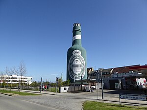
Tuborg Bottle
Distance: Approx. 951 meters
Latitude and longitude: 55.72330556,12.57844444
The Tuborg Bottle (Danish: Tuborgflasken) is a 26 metres tall landmark shaped as a Tuborg bottle located close to Tuborg's former brewery site, now Tuborg Havn, Hellerup, in the northern suburbs of Copenhagen, Denmark.

Lundevangsvej 12
Villa in Copenhagen, Denmark
Distance: Approx. 642 meters
Latitude and longitude: 55.72513056,12.57126111
Lundevangsvej 12 is a Carl Brummer-designed villa in the Ryvangen quarter of Copenhagen, Denmark. It was listed in the Danish registry of protected buildings and places in 1995. Metallica drummer and co-founder Lars Ulrich lived in the house for the first 17 years of his life.

Ehlersvej 17
Building in Copenhagen, Denmark
Distance: Approx. 310 meters
Latitude and longitude: 55.72811944,12.57166111
Ehlersvej 17 is a functionalist house designed by Frits Schlegel and situated on Ehlersvej in the Østerbro district of Copenhagen, Denmark. It was listed in the Danish registry of protected buildings and places in 2001.
Weather in this IP's area
overcast clouds
18 Celsius
19 Celsius
17 Celsius
19 Celsius
1013 hPa
93 %
1013 hPa
1011 hPa
10000 meters
3.09 m/s
80 degree
100 %
06:28:44
19:46:15