Country:
 Denmark
Region:
City:
Latitude and Longitude:
Time Zone:
Postal Code:
IP information under different IP Channel
ip-api
Country
Region
City
ASN
Time Zone
ISP
Blacklist
Proxy
Latitude
Longitude
Postal
Route
IPinfo
Country
Region
City
ASN
Time Zone
ISP
Blacklist
Proxy
Latitude
Longitude
Postal
Route
MaxMind
Country
Region
City
ASN
Time Zone
ISP
Blacklist
Proxy
Latitude
Longitude
Postal
Route
Luminati
Country
DKRegion
84
City
elsinore
ASN
Time Zone
Europe/Copenhagen
ISP
GlobalConnect A/S
Latitude
Longitude
Postal
db-ip
Country
Region
City
ASN
Time Zone
ISP
Blacklist
Proxy
Latitude
Longitude
Postal
Route
ipdata
Country
Region
City
ASN
Time Zone
ISP
Blacklist
Proxy
Latitude
Longitude
Postal
Route
Popular places and events near this IP address

Aalborg Municipality
Municipality in Nordjylland region of Denmark
Distance: Approx. 557 meters
Latitude and longitude: 57.0464,9.9192
Ålborg Municipality (Danish: Ålborg Kommune) is a municipality in North Jutland Region on the Jutland peninsula in northern Denmark. The municipality straddles the Limfjord, the waterway which connects the North Sea and the Kattegat east-to-west, and which separates the main body of the Jutland peninsula from the island of Vendsyssel-Thy north-to-south. It has a land area of 1,143.99 km2 (441.70 sq mi) and a population of 223,174 (1.
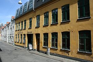
1000Fryd
Distance: Approx. 661 meters
Latitude and longitude: 57.0472,9.9201
1000Fryd is a small café, bar, and community center with a stage, a recording studio, a cinema, and an art gallery, located in Aalborg, Denmark. Since 1000Fryd opened in 1984 there have been thousands of concerts by both well known bands – such as Die Toten Hosen and Green Day – and utterly obscure local performers, such as Jimmy Justice and Columbian Neckties. It is a focus of the successful novel Nordkraft by Jakob Ejersbo.

Aalborg University Hospital
Hospital in North Denmark Region, Denmark
Distance: Approx. 594 meters
Latitude and longitude: 57.03788056,9.90850833
Aalborg University Hospital is the largest hospital in the North Denmark Region, Denmark. It is also northern Jutland's largest employer, with approximately 6,500 employees. The hospital consists of Section South and North in Aalborg and Dronninglund Hospital.

Aalborgtårnet
Distance: Approx. 581 meters
Latitude and longitude: 57.04138889,9.905
Aalborgtårnet (Aalborg Tower) is a 54.9 metre tall observation tower built of lattice steel in Aalborg, Denmark. The tower is built on a hill, providing a total height of 105 metres above sea level. The tower has a restaurant on the top.

KUNSTEN Museum of Modern Art Aalborg
Art museum in Denmark
Distance: Approx. 537 meters
Latitude and longitude: 57.04263889,9.90569444
KUNSTEN Museum of Modern Art is located in Aalborg, Denmark, on Kong Christians Allé near its junction with Vesterbro. Of a modern Scandinavian design, it was built between 1968 and 1972 by Finnish architects Elissa and Alvar Aalto and Danish architect Jean-Jacques Baruël. It was completed on 8 June 1972.

Aalborg Carnival
Distance: Approx. 31 meters
Latitude and longitude: 57.042185,9.914007
Aalborg Carnival is the name for the annual cultural event carnival in the city of Aalborg – the fourth-largest city in Denmark. The carnival takes place the last week in May (week 21) and is the largest carnival in Scandinavia (advertised as "the biggest carnival in northern Europe"). The Aalborg Carnival stands for a week and has three main carnival events: The Grand Parade, Battle of Carnival Bands and Children's Carnival.
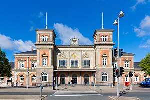
Aalborg railway station
The main railway station in Aalborg, Denmark
Distance: Approx. 182 meters
Latitude and longitude: 57.04305556,9.91694444
Aalborg railway station (Danish: Aalborg Station or Aalborg Banegård) is the main railway station serving the city of Aalborg, Denmark. It is located in central Aalborg, on the southwestern edge of the city center, with entrances from John F. Kennedys Plads and access to platforms from Kildeparken. Aalborg railway station is serving as a connecting hub for rail traffic between North Jutland and the rest of Denmark.
Aalborghallen
Distance: Approx. 177 meters
Latitude and longitude: 57.04361111,9.91361111
Aalborg Kongres & Kultur Center (formally and unofficially Aalborghallen) is an entertainment and convention venue located in Aalborg, Denmark, which is used for exhibitions and concerts. The facility was inaugurated in 1953 and has a capacity of 3,000 people. The first Aalborghall was built in 1933.
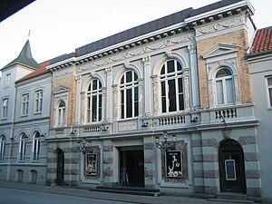
Aalborg Teater
Theatre in Aalborg, Denmark
Distance: Approx. 563 meters
Latitude and longitude: 57.047014,9.916667
Aalborg Teater is the main theatre in Aalborg, Denmark. Built in 1878, it was subsequently modified by Julius Petersen and was remodeled in 2000. Its address is still Jernbanegade (Railway Street), although the station and the theatre have both moved.

John F. Kennedys Plads
Square in Aalborg, Denmark
Distance: Approx. 240 meters
Latitude and longitude: 57.043056,9.918056
John F. Kennedys Plads ("John F. Kennedy's Square") is located in central Aalborg, Denmark. Dedicated to the 35th President of the United States, it contains a horse and rider statue of Christian IX of Denmark. Reserved for pedestrians, the site is constructed of granite and concrete tiles.

Kildeparken
Public park in Aalborg, Denmark
Distance: Approx. 41 meters
Latitude and longitude: 57.041944,9.913889
Kildeparken (locally, "Kilden") is a large public park in Aalborg, Denmark. It is bounded by the streets Europahallen, Vesterbro, Old Kærvej, and the railway. It is possible to reach it from John F. Kennedys Plads through a tunnel.
Almen Kirkegård
Distance: Approx. 474 meters
Latitude and longitude: 57.04472222,9.90833333
The Almen Kirkegård (meaning "General Cemetery") in Aalborg, Denmark. is located in serene and green surroundings. Located in Hasserisgade, it is one of the three cemeteries of the Aalborg Municipality; the other two are the Southern Cemetery at Blomstermarken and the Eastern Cemetery at Filstedvej.
Weather in this IP's area
broken clouds
19 Celsius
19 Celsius
18 Celsius
19 Celsius
1012 hPa
88 %
1012 hPa
1011 hPa
10000 meters
4.63 m/s
100 degree
75 %
06:37:29
19:58:45