Country:
Region:
City:
Latitude and Longitude:
Time Zone:
Postal Code:
IP information under different IP Channel
ip-api
Country
Region
City
ASN
Time Zone
ISP
Blacklist
Proxy
Latitude
Longitude
Postal
Route
Luminati
Country
Region
84
City
elsinore
ASN
Time Zone
Europe/Copenhagen
ISP
GlobalConnect A/S
Latitude
Longitude
Postal
IPinfo
Country
Region
City
ASN
Time Zone
ISP
Blacklist
Proxy
Latitude
Longitude
Postal
Route
db-ip
Country
Region
City
ASN
Time Zone
ISP
Blacklist
Proxy
Latitude
Longitude
Postal
Route
ipdata
Country
Region
City
ASN
Time Zone
ISP
Blacklist
Proxy
Latitude
Longitude
Postal
Route
Popular places and events near this IP address

Helsingør
City in North Zealand, Denmark
Distance: Approx. 1647 meters
Latitude and longitude: 56.03611111,12.60833333
Helsingør ( HEL-sing-UR, Danish: [helse̝ŋˈøɐ̯ˀ]; Swedish: Helsingör), classically known in English as Elsinore ( EL-sin-or, -OR), is a coastal city in northeastern Denmark. Helsingør Municipality had a population of 63,838 on 1 January 2024, making it the 23rd most populated municipality in Denmark. Helsingør is located at the narrowest part of the Øresund strait and together with Helsingborg in Sweden, forms the northern reaches of the Øresund Region, centred on Copenhagen and Malmö.
International People's College
Distance: Approx. 607 meters
Latitude and longitude: 56.0284,12.5898
The International People's College is a folk high school in Helsingør in the northern part of Zealand, Denmark, one hour from the capital city Copenhagen. It is a progressive residential international school that emphasizes community and teaches global awareness and tolerance. Up to around 110 students total, from many different countries around the world and varying ages as well, attend the school each term.
Helsingør Gymnasium
Public High School in Elsinore, Denmark
Distance: Approx. 1092 meters
Latitude and longitude: 56.02249444,12.58529444
Helsingør Gymnasium (In English: Elsinore High School) is a high school in Elsinore, Denmark. It opened in 1978 in an existing set of buildings from the 60s. Earlier Espergaerde High School had the name "Elsinore High School".
Vapnagård
Housing project in Helsingør, Denmark
Distance: Approx. 1363 meters
Latitude and longitude: 56.02,12.581
Vapnagård is a large housing project in Helsingør, Denmark. Approx. 4000 people live in the 57 concrete blocks.

Kingo Houses
Building in Helsingør, Denmark
Distance: Approx. 271 meters
Latitude and longitude: 56.03210833,12.57844444
Kingo Houses is a housing development designed by architect Jørn Utzon in Helsingør, Denmark. The development consists of 60 L-shaped houses based upon the design of traditional Danish farmhouses with central courtyards and those of Chinese and Islamic dwellings.

Marienlyst Castle
Palace building in Helsingør, Denmark
Distance: Approx. 1615 meters
Latitude and longitude: 56.042,12.60194444
Marienlyst Castle (Danish: Marienlyst Slot) is a palatial residence located in Helsingør, Denmark. It was named after King Frederik V of Denmark's second wife, Juliana Maria, the queen consort of Denmark and Norway. The building formerly served as a royal pavilion of Kronborg Castle and was mostly used as a venue for pleasure and hunting.

Gurrevejsstiftelsen
Distance: Approx. 924 meters
Latitude and longitude: 56.03629167,12.59572222
Gurrevejsstiftelsen, also known as Helsingør Kommunes Alderdomsstiftelse is a residential complex for senior citizens in Helsingør, Denmark. Built in 1918–1921 to design by Poul Holsøe, it is an early manifestation of the emerging welfare state and became a model for similar projects. It was listed in 1995.

Spæth House
Distance: Approx. 1612 meters
Latitude and longitude: 56.03153056,12.60869167
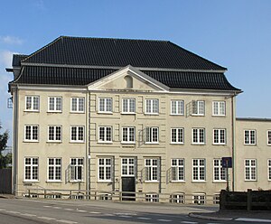
The Spæth House is a Rococo-style mansion in Helsingør, Denmark. It was built by the first sugar manufacturer in Helsingør and served both as residence and warehouse. The building is listed and now houses a public music school for local youth.

St. Vincent's Church, Helsingør
Church in Helsingør, Denmark
Distance: Approx. 1664 meters
Latitude and longitude: 56.03744444,12.60786111
St. Vincent Church (Danish: Sankt Vincent Kirke) is a parish of the Roman Catholic Church in Helsingør, Denmark. The church, consecrated in 1930, is the only Roman Catholic church in North Zealand.

Helsingør Cemetery
Cemetery in Denmark
Distance: Approx. 1457 meters
Latitude and longitude: 56.03638889,12.605
Helsingør Cemetery (Danish: Helsingør Kirkegård) is a cemetery in Helsingør, Denmark. It serves the parishes of St. Olai, St.

Valnøddevænget 10
Listed building in Helsingør, Denmark
Distance: Approx. 1490 meters
Latitude and longitude: 56.01978056,12.59171944
Valnøddevænget 10, also known as Villa Gøjgaard, is a house designed by Kay Fisker in the Snekkersten district of Helsingør, Denmark. It was listed in the Danish registry of protected buildings and places in 1988.

Iver Pedersen House
Listed townhouse in Helsingør, Denmark
Distance: Approx. 1685 meters
Latitude and longitude: 56.03308889,12.60983889
The Iver Pedersen House (Danish: Iver Pedersens Gård) is one of the oldest half-timbered buildings in Helsingør, Denmark. It was listed in the Danish registry of protected buildings and places in 1919.
Weather in this IP's area
overcast clouds
9 Celsius
9 Celsius
9 Celsius
10 Celsius
1029 hPa
88 %
1029 hPa
1024 hPa
10000 meters
0.45 m/s
2.24 m/s
220 degree
100 %
07:23:40
16:22:46