Country:
 Italy
ItalyRegion:
City:
Latitude and Longitude:
Time Zone:
Postal Code:
IP information under different IP Channel
ip-api
Country
Region
City
ASN
Time Zone
ISP
Blacklist
Proxy
Latitude
Longitude
Postal
Route
IPinfo
Country
Region
City
ASN
Time Zone
ISP
Blacklist
Proxy
Latitude
Longitude
Postal
Route
MaxMind
Country
Region
City
ASN
Time Zone
ISP
Blacklist
Proxy
Latitude
Longitude
Postal
Route
Luminati
Country
ITASN
Time Zone
Europe/Rome
ISP
Wind Tre S.p.A.
Latitude
Longitude
Postal
db-ip
Country
Region
City
ASN
Time Zone
ISP
Blacklist
Proxy
Latitude
Longitude
Postal
Route
ipdata
Country
Region
City
ASN
Time Zone
ISP
Blacklist
Proxy
Latitude
Longitude
Postal
Route
Popular places and events near this IP address
Expo 2015
World Expo held in Milan, Italy
Distance: Approx. 1612 meters
Latitude and longitude: 45.51861111,9.10666667
Expo 2015 was a World Expo hosted by Milan, Italy. It opened on May 1 at 10:00 CEST and closed on October 31. Milan hosted an exposition for the second time; the first was the 1906 Milan International.
Pero, Lombardy
Comune in Lombardy, Italy
Distance: Approx. 324 meters
Latitude and longitude: 45.51666667,9.08333333
Pero (Milanese: Per [ˈpeːr]) is a comune (municipality) in the Province of Milan in the Italian region Lombardy, located about 9 kilometres (6 mi) northwest of Milan. As of 31 December 2004, it had a population of 10,378 and an area of 5.0 square kilometres (1.9 sq mi). The municipality of Pero contains the frazioni (subdivisions, mainly villages and hamlets) Cerchiate and Cerchiarello.

Baranzate
Comune in Lombardy, Italy
Distance: Approx. 1120 meters
Latitude and longitude: 45.51666667,9.1
Baranzate (Milanese: Baranzaa [barãˈtsaː]), formerly a frazione of the neighboring comune of Bollate, is a comune (municipality) in the Metropolitan City of Milan, in the Italian region of Lombardy, about 8 kilometres (5 mi) northwest of Milan. It was created in 2004 after its previous establishment, in 2001, was declared unconstitutional. Baranzate is bordered by Bollate to the north and northwest, Novate Milanese to the east, and Milan's Roserio district to the south and southwest.

Monte Amiata Housing
Housing estate in Milan
Distance: Approx. 2443 meters
Latitude and longitude: 45.49962,9.10097
Monte Amiata Housing is a residential complex in the Gallaratese district of Milan, Italy, designed by architects Carlo Aymonino and Aldo Rossi in the late 1960s. It is sometimes referred to as the "Red Dinosaur" in reference both to the reddish color of the buildings and the oddity of their design. The project is well known in the international architecture community, and regarded as one of those that better represent Aymonino's vision of the city as a turbulent, intricate, and varied texture, a paradigm that is known as "fragmentism".

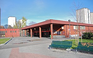
Rho Fiera (Milan Metro)
Milan metro station
Distance: Approx. 131 meters
Latitude and longitude: 45.51983333,9.08702778
Rho Fiera is a station on Line 1 of the Milan Metro in Rho, Lombardy, Italy. It was opened on 14 September 2005 as a one-station extension from Molino Dorino; Pero station was only added on 19 December 2005. The station provides service to the FieraMilano exhibitition centre and is the current western terminus of the line.

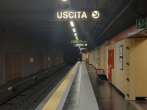
Rho Fiera railway station
Railway station in Italy
Distance: Approx. 294 meters
Latitude and longitude: 45.52111111,9.08805556
Rho Fiera railway station is a railway station in Italy. Located on the Turin–Milan railway, it serves the Fieramilano area in Rho. The station is located on Achille Grandi street.
San Leonardo (Milan Metro)
Milan metro station
Distance: Approx. 2312 meters
Latitude and longitude: 45.5012,9.1015
San Leonardo is a station on Line 1 of the Milan Metro in Milan, Italy. The station was opened on 12 April 1980 as the western terminus of the extension from Lotto to San Leonardo. On 28 September 1986, the line was extended to Molino Dorino.

Molino Dorino (Milan Metro)
Milan metro station
Distance: Approx. 1628 meters
Latitude and longitude: 45.5052,9.0933
Molino Dorino is a station on Line 1 of the Milan Metro in Milan, Italy. The station was opened on 28 September 1986 as a one-station extension of the line from San Leonardo. On 14 September 2005, the line was extended to Rho Fiera; Pero station was only added on 19 December 2005.
Pero (Milan Metro)
Milan metro station
Distance: Approx. 1056 meters
Latitude and longitude: 45.50972222,9.08944444
Pero is a station on Line 1 of the Milan Metro. The station is located on Via Olona, which is in Pero, Italy. It was opened on 19 December 2005 on the section between Molino Dorino and Rho Fiera, which was already in operation.
Expo 2015 pavilions
Distance: Approx. 1612 meters
Latitude and longitude: 45.51861111,9.10666667
This article contains the details of the pavilions in Expo 2015. The 2015 World Expo Milan covers more than 2.9 square kilometers and contains more than 70 exposition pavilions. More than 145 countries and 50 international organizations registered to participate in the 2015 Milan Expo.
Milan Innovation District
Urban development in Milan, Italy
Distance: Approx. 1612 meters
Latitude and longitude: 45.51861111,9.10666667
Milano Innovation District (MIND) is the name given to the project dedicated to the area where Expo 2015 took place in Milan.
Cascina Merlata
Quartier of Milan in Lombardy, Italy
Distance: Approx. 1518 meters
Latitude and longitude: 45.51055556,9.10138889
Cascina Merlata is a district ("quartiere") of Milan, Italy, part of the Zone 8 administrative division of the city. It is adjacent to the Expo 2015 exhibition site and borders the districts of Roserio, Gallaratese and Musocco, as well as the municipality of Pero.
Weather in this IP's area
heavy intensity rain
21 Celsius
22 Celsius
20 Celsius
22 Celsius
1012 hPa
91 %
1012 hPa
996 hPa
10000 meters
0.45 m/s
2.24 m/s
88 degree
100 %
06:53:58
19:48:53