Country:
 Italy
ItalyRegion:
City:
Latitude and Longitude:
Time Zone:
Postal Code:
IP information under different IP Channel
ip-api
Country
Region
City
ASN
Time Zone
ISP
Blacklist
Proxy
Latitude
Longitude
Postal
Route
IPinfo
Country
Region
City
ASN
Time Zone
ISP
Blacklist
Proxy
Latitude
Longitude
Postal
Route
MaxMind
Country
Region
City
ASN
Time Zone
ISP
Blacklist
Proxy
Latitude
Longitude
Postal
Route
Luminati
Country
ITRegion
72
City
acerra
ASN
Time Zone
Europe/Rome
ISP
Wind Tre S.p.A.
Latitude
Longitude
Postal
db-ip
Country
Region
City
ASN
Time Zone
ISP
Blacklist
Proxy
Latitude
Longitude
Postal
Route
ipdata
Country
Region
City
ASN
Time Zone
ISP
Blacklist
Proxy
Latitude
Longitude
Postal
Route
Popular places and events near this IP address
Capena
Comune in Lazio, Italy
Distance: Approx. 8954 meters
Latitude and longitude: 42.14027778,12.54027778
Capena (until 1933 called Leprignano) is a town and comune in the Metropolitan City of Rome, Lazio region (central Italy). The town has borrowed its modern name from a pre-Roman and Roman settlement that was 3 kilometres (1.9 mi) to its north.

Lucus Feroniae
Archaeological site in Capena, Italy
Distance: Approx. 5734 meters
Latitude and longitude: 42.13,12.59666667
Lucus Feroniae was an ancient sanctuary or, literally sacred grove ("lucus"), dedicated to the Sabine goddess Feronia, protector of freedmen, ex-slaves. It was located near to the ancient town of Feronia in Etruria on the ancient Via Tiberina, in what is now the territory of the modern commune of Capena, Lazio. It was partially excavated when the A1 Rome-Milan motorway which crosses it was built, and the archaeological site is adjacent to that of the ancient Roman Villa dei Volusii.
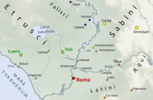
Crustumerium
Ancient town of Latium
Distance: Approx. 3333 meters
Latitude and longitude: 42.05,12.61666667
Crustumerium (or Crustumium) was an ancient town of Latium, on the edge of the Sabine territory, near the headwaters of the Allia, not far from the Tiber. In the legends concerning Rome's early history, the Crustumini were amongst the peoples which attended Romulus' festival of Neptune Equester. At that festival, the Roman men seized the young women amongst the visiting spectators, an event known as the Rape of the Sabine Women.

Fiano Romano
Comune in Lazio, Italy
Distance: Approx. 9728 meters
Latitude and longitude: 42.16666667,12.6
Fiano Romano is a town and comune (municipality) in the Metropolitan City of Rome, Italy, approximately 40 kilometres (25 mi) north of the city. Fiano Romano borders the following municipalities: Capena, Civitella San Paolo, Montelibretti, Montopoli di Sabina, Nazzano.

Riano, Lazio
Comune in Lazio, Italy
Distance: Approx. 8161 meters
Latitude and longitude: 42.1,12.51666667
Riano is a comune (municipality) in the Metropolitan City of Rome in the Italian region of Latium. It is located about 20 kilometres (12 mi) north of Rome, in the Tiber River valley, not far from Veio. Riano borders the following municipalities: Castelnuovo di Porto, Monterotondo, Rome, Sacrofano.
Fonte Nuova
Comune in Lazio, Italy
Distance: Approx. 8729 meters
Latitude and longitude: 42.00166667,12.62194444
Fonte Nuova is a comune (municipality) in the Metropolitan City of Rome in the Italian region Lazio, located about 15 kilometres (9 mi) northeast of Rome. The comune was created in 2001 from the frazioni of Tor Lupara di Mentana and Santa Lucia di Mentana, once belonging to Mentana, and that of Tor Lupara of Guidonia Montecelio.
Borgo Santa Maria, Montelibretti
Frazione in Lazio, Italy
Distance: Approx. 10006 meters
Latitude and longitude: 42.15361111,12.68055556
Borgo Santa Maria is a small town located 30 km north-east of Rome. It is a hamlet belonging to the municipality of Montelibretti. It is situated on the Via Salaria, Km 38, close to other towns as Passo Corese and Borgo Quinzio.
Cretone
Distance: Approx. 7315 meters
Latitude and longitude: 42.08333333,12.7
Cretone is a frazione of the comune of Palombara Sabina, in the Province of Rome, Italy.

Passo Corese
Frazione in Lazio, Italy
Distance: Approx. 9247 meters
Latitude and longitude: 42.15694444,12.65277778
Passo Corese is an Italian town and hamlet (frazione) of Fara in Sabina, a municipality in the province of Rieti, Lazio. In 2011 it had a population of 3,573.

Pozzo del Merro
Flooded sinkhole in the countryside northeast of Rome, Italy
Distance: Approx. 7256 meters
Latitude and longitude: 42.0393,12.6805
Pozzo del Merro is a flooded sinkhole in the countryside northeast of Rome, Italy. Situated at the bottom of an 80 m conical pit, at 392 m (1,286 ft) it is the second deepest underwater vertical cave in the world. In 2000 two ROVs were sent to explore its depths; the first, the "Mercurio (Mercury)" reached its maximum operative depth of 210 m (690 ft) without reaching the bottom.

Villa dei Volusii
Distance: Approx. 5980 meters
Latitude and longitude: 42.1328,12.60061111
The ancient Roman Villa dei Volusii or Villa dei Volusii-Saturnini is an archaeological site located in the municipality of Fiano Romano, next to the ancient Roman town and sanctuary of Lucus Feroniae, along the route of ancient Via Tiberina. This villa is a unique example of an almost entirely excavated large senatorial villa in Italy. It was a luxurious villa owned by the politically powerful senatorial family of the Volusii Saturnini, and one of the largest Roman villas.
Weather in this IP's area
moderate rain
20 Celsius
20 Celsius
18 Celsius
20 Celsius
1015 hPa
84 %
1015 hPa
1011 hPa
10000 meters
1.34 m/s
2.24 m/s
40 degree
100 %
07:25:38
18:23:20