Country:
 Italy
ItalyRegion:
City:
Latitude and Longitude:
Time Zone:
Postal Code:
IP information under different IP Channel
ip-api
Country
Region
City
ASN
Time Zone
ISP
Blacklist
Proxy
Latitude
Longitude
Postal
Route
IPinfo
Country
Region
City
ASN
Time Zone
ISP
Blacklist
Proxy
Latitude
Longitude
Postal
Route
MaxMind
Country
Region
City
ASN
Time Zone
ISP
Blacklist
Proxy
Latitude
Longitude
Postal
Route
Luminati
Country
ITRegion
32
City
rovereto
ASN
Time Zone
Europe/Rome
ISP
Wind Tre S.p.A.
Latitude
Longitude
Postal
db-ip
Country
Region
City
ASN
Time Zone
ISP
Blacklist
Proxy
Latitude
Longitude
Postal
Route
ipdata
Country
Region
City
ASN
Time Zone
ISP
Blacklist
Proxy
Latitude
Longitude
Postal
Route
Popular places and events near this IP address

Isera
Comune in Trentino-Alto Adige/Südtirol, Italy
Distance: Approx. 2061 meters
Latitude and longitude: 45.88333333,11.01666667
Isera (Iséra in local dialect) is a comune (municipality) in Trentino in the northern Italian region Trentino-Alto Adige/Südtirol, located about 20 kilometres (12 mi) southwest of Trento. As of 31 December 2004, it had a population of 2,496 and an area of 14.1 square kilometres (5.4 sq mi). The municipality of Isera contains the frazioni (subdivisions, mainly villages and hamlets) Marano, Cornalé, Reviano, Folaso, Patone, Lenzima and Bordala.
Nogaredo
Comune in Trentino-Alto Adige/Südtirol, Italy
Distance: Approx. 3450 meters
Latitude and longitude: 45.91666667,11.03333333
Nogaredo (Nogarédo in local dialect) is a comune (municipality) in Trentino in the northern Italian region Trentino-Alto Adige/Südtirol, located about 20 kilometres (12 mi) southwest of Trento. As of 31 December 2004, it had a population of 1,747 and an area of 3.6 square kilometres (1.4 sq mi). Nogaredo borders the following municipalities: Villa Lagarina, Isera and Rovereto.

Pomarolo
Comune in Trentino-Alto Adige/Südtirol, Italy
Distance: Approx. 5253 meters
Latitude and longitude: 45.93333333,11.05
Pomarolo (Pomaròl in local dialect) is a comune (municipality) in Trentino located around 15 kilometres (9 mi) southwest of Trento in the northern Italian region of Trentino-Alto Adige/Südtirol.
Trambileno
Comune in Trentino-Alto Adige/Südtirol, Italy
Distance: Approx. 2867 meters
Latitude and longitude: 45.86666667,11.06666667
Trambileno (Trambelém in local dialect) is a comune (municipality) in Trentino in the northern Italian region Trentino-Alto Adige/Südtirol, located about 25 kilometres (16 mi) south of Trento. Trambileno borders the following municipalities: Rovereto, Terragnolo, Vallarsa, Posina and Valli del Pasubio. It is known as the location of the Eremo di San Colombano monastery, a church set on a rock ledge.

Volano
Comune in Trentino-Alto Adige/Südtirol, Italy
Distance: Approx. 3839 meters
Latitude and longitude: 45.91666667,11.06666667
Volano is a comune (municipality) in Trentino in the northern Italian region Trentino-Alto Adige/Südtirol, located about 15 kilometres (9 mi) south of Trento. As of 31 December 2004, it had a population of 2,851 and an area of 10.8 square kilometres (4.2 sq mi). Volano borders the following municipalities: Calliano, Pomarolo, Nomi and Rovereto.

Rovereto railway station
Railway station in Rovereto, Italy
Distance: Approx. 855 meters
Latitude and longitude: 45.89083333,11.03388889
Rovereto railway station (Italian: Ferrovie Stazione di Rovereto) serves the Comune of Rovereto in the autonomous province of Trentino, northeastern Italy. The station was opened in 1859 by the Austrian Empire's Südbahn and transferred to Italy in 1919. Rovereto station is located on the trans-Alpine Brenner Railway connecting Verona and Innsbruck.

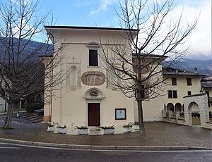
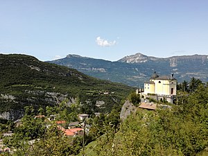
Eremo di San Colombano
Hermitage in Trambileno, Italy
Distance: Approx. 1726 meters
Latitude and longitude: 45.87805556,11.06166667
Eremo di San Colombano is a hermitage in Trambileno, Italy, notable for its location in the side of a mountain. Some natural caves, halfway up the rock wall of the gorge formed by the stream of Leno Vallarsa were certainly used from 753 (the date inscribed on the rock) from a Monaco hermit.

Castellano, Trentino
Frazione in Trentino-Alto Adige/Südtirol, Italy
Distance: Approx. 3450 meters
Latitude and longitude: 45.91666667,11.03333333
Castellano (German: Kastellein) is a little village which is a frazione of the municipality of Villa Lagarina in Trentino. It was the most important village of the Feudo of Castellano and during the Austria-Hungary period was the site of the Comune di Castellano, abolished in 1929. It is famous for its ancient castle (Castle of Castellano) which became very important under the Lodron and in World War I because it became an Austrian fortress.

Castle of Castellano
Manor house in Trentino, Italy
Distance: Approx. 4796 meters
Latitude and longitude: 45.92116,11.00632
The Castle of Castellano (Italian: Castello di Castellano, German: Schloss Kastellein) is a manor house in the village of Castellano, in the municipality of Villa Lagarina, in Trentino, northern Italy. It is one of the most famous castles of Vallagarina, offering a panorama of the entire valley, and was used to protect roads leading to Lago di Cei. Constructed in the 12th century, the castle was conquered by the Castelbarco family in the mid-13th century, before being acquired by the counts of Lodron in 1456.

Manifattura Tabacchi
Tobacco factory in Rovereto, Trentino-Alto Adige, Italy
Distance: Approx. 1706 meters
Latitude and longitude: 45.8838,11.0212
In the 1800s, when the Austro-Hungarian Empire controlled the territories of the upper Adige valley in northern Italy, a tobacco plant was built in the town of Borgo Sacco, now part of the city of Rovereto. An earlier name for this tobacco factory was Imperia Regia Manifattura d'Austria-Ungheria (translation: Imperial and Royal Tobacco Manufacturing of the Austro-Hungarian Empire).

Vallagarina (district)
District in Italy
Distance: Approx. 2318 meters
Latitude and longitude: 45.86666667,11.03333333
Vallagarina (German: Lagertal) is one of the sixteen districts of Trentino in the Italian region of Trentino-Alto Adige/Südtirol. Its administrative seat and major town is Rovereto.

Museum of Modern and Contemporary Art of Trento and Rovereto
Art museum in Rovereto TN, Italy
Distance: Approx. 862 meters
Latitude and longitude: 45.894,11.045
The Museum of Modern and Contemporary Art of Trento and Rovereto (MART) (Museo d'Arte Moderna e Contemporanea di Trento e Rovereto, in Italian) is a museum centre in the Italian province of Trento. The main site is in Rovereto, and contains mostly modern and contemporary artworks, including works from renowned Giorgio Morandi, Giorgio de Chirico, Antonio Rotta, Felice Casorati, Carlo Carrà, and Fortunato Depero. Fortunato Depero's house in Rovereto (known as Casa d'Arte Futurista Depero) is also part of the Museum.
Weather in this IP's area
light rain
24 Celsius
24 Celsius
22 Celsius
25 Celsius
1014 hPa
88 %
1014 hPa
992 hPa
10000 meters
2.79 m/s
4.06 m/s
194 degree
100 %
06:45:48
19:41:24