Country:
 Italy
ItalyRegion:
City:
Latitude and Longitude:
Time Zone:
Postal Code:
IP information under different IP Channel
ip-api
Country
Region
City
ASN
Time Zone
ISP
Blacklist
Proxy
Latitude
Longitude
Postal
Route
IPinfo
Country
Region
City
ASN
Time Zone
ISP
Blacklist
Proxy
Latitude
Longitude
Postal
Route
MaxMind
Country
Region
City
ASN
Time Zone
ISP
Blacklist
Proxy
Latitude
Longitude
Postal
Route
Luminati
Country
ITRegion
72
City
acerra
ASN
Time Zone
Europe/Rome
ISP
Wind Tre S.p.A.
Latitude
Longitude
Postal
db-ip
Country
Region
City
ASN
Time Zone
ISP
Blacklist
Proxy
Latitude
Longitude
Postal
Route
ipdata
Country
Region
City
ASN
Time Zone
ISP
Blacklist
Proxy
Latitude
Longitude
Postal
Route
Popular places and events near this IP address

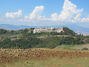
Acquapendente
Comune in Lazio, Italy
Distance: Approx. 3270 meters
Latitude and longitude: 42.74388889,11.86444444
Acquapendente is a city and comune in the province of Viterbo, in Lazio (Italy). Acquapendente is a centre for the agricultural production of vegetables and wine, and has a tradition of pottery craftsmanship. Its frazione of Torre Alfina is one of I Borghi più belli d'Italia ("The most beautiful villages of Italy").

Onano
Comune in Lazio, Italy
Distance: Approx. 8318 meters
Latitude and longitude: 42.68333333,11.81666667
Onano is a comune (municipality) in the Province of Viterbo in the Italian region Lazio, located about 100 kilometres (62 mi) northwest of Rome and about 40 kilometres (25 mi) northwest of Viterbo. Onano borders the following municipalities: Acquapendente, Gradoli, Grotte di Castro, Latera, Sorano. Alongside Ala, Ateleta, Orero and Siris, it is one of five Italian municipalities with a palindromic name.
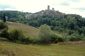
Proceno
Comune in Lazio, Italy
Distance: Approx. 1309 meters
Latitude and longitude: 42.75,11.81666667
Proceno is a comune (municipality) in the Province of Viterbo in the Italian region of Latium, located about 110 kilometres (68 mi) northwest of Rome and about 45 kilometres (28 mi) northwest of Viterbo. Proceno borders the following municipalities: Acquapendente, Castell'Azzara, Piancastagnaio, San Casciano dei Bagni, Sorano. Saint Agnes of Montepulciano established a monastery here.

Lago di San Casciano
Distance: Approx. 9312 meters
Latitude and longitude: 42.839771,11.849613
Lago di San Casciano is a lake in the Province of Siena, Tuscany, Italy. At an elevation of 383 m, its surface area is 2 km2.
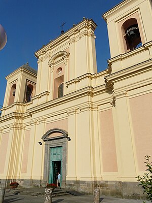
Acquapendente Cathedral
Distance: Approx. 3835 meters
Latitude and longitude: 42.7426,11.8713
Acquapendente Cathedral (Italian: Duomo di Acquapendente, Basilica Cattedrale di San Sepolcro) is a Roman Catholic cathedral, dedicated to the Holy Sepulchre, in the town of Acquapendente in Lazio, Italy. Formerly the episcopal seat of the Diocese of Acquapendente, it is now a co-cathedral in the Diocese of Viterbo.
Museo del fiore
Museum in Lazio, Italy
Distance: Approx. 8046 meters
Latitude and longitude: 42.7397,11.9244
The Museo del Fiore is a small naturalistic, multimedial and interactive museum, located in Italy, in the woods of the Monte Rufeno natural reserve which is 10 km from Acquapendente (Viterbo) and 2 km from the characteristic medieval city of Torre Alfina. It is inside an old rural building, "Casale Giardino". With more than 1,000 species of known plants in its territories and rare animals, the Monte Rufeno natural reserve, at the border with Umbria and Tuscany, is an area with a large variety of plants and wildlife.
Trevinano
Frazione in Lazio, Italy
Distance: Approx. 8022 meters
Latitude and longitude: 42.82278056,11.8706
Trevinano is an Italian village, frazione of Acquapendente, in the Province of Viterbo, northern Lazio. As of 2011, its population was of 142.

Castell'Ottieri
Frazione in Tuscany, Italy
Distance: Approx. 6966 meters
Latitude and longitude: 42.73166667,11.75138889
Castell'Ottieri is a village in Tuscany, central Italy, administratively a frazione of the comune of Sorano, province of Grosseto, in the tuff area of southern Maremma. At the time of the 2001 census its population amounted to 195. Castell'Ottieri is about 90 km from Grosseto and 10 km from Sorano, and it is situated along the Provincial Road which links Sorano to Castell'Azzara.

Montorio, Sorano
Frazione in Tuscany, Italy
Distance: Approx. 5370 meters
Latitude and longitude: 42.74166667,11.76694444
Montorio is a village in Tuscany, central Italy, administratively a frazione of the comune of Sorano, province of Grosseto, in the tuff area of southern Maremma.

San Giovanni delle Contee
Frazione in Tuscany, Italy
Distance: Approx. 5340 meters
Latitude and longitude: 42.75361111,11.76388889
San Giovanni delle Contee is a village in Tuscany, central Italy, administratively a frazione of the comune of Sorano, province of Grosseto, in the tuff area of southern Maremma. At the time of the 2001 census its population amounted to 224. San Giovanni delle Contee is about 90 km from Grosseto and 12 km from Sorano, and it is situated along the Provincial Road which links Sorano to Castell'Azzara.

San Valentino, Sorano
Frazione in Tuscany, Italy
Distance: Approx. 9572 meters
Latitude and longitude: 42.70361111,11.73777778
San Valentino is a village in Tuscany, central Italy, administratively a frazione of the comune of Sorano, province of Grosseto, in the tuff area of southern Maremma. At the time of the 2001 census, its population was 58. San Valentino is about 90 kilometres (56 miles) from Grosseto and 9 kilometres (5.6 miles) from Sorano.
Weather in this IP's area
overcast clouds
17 Celsius
17 Celsius
16 Celsius
17 Celsius
1016 hPa
87 %
1016 hPa
971 hPa
10000 meters
0.89 m/s
1.79 m/s
32 degree
100 %
07:29:34
18:25:39