Country:
 Iran
IranRegion:
City:
Latitude and Longitude:
Time Zone:
Postal Code:
IP information under different IP Channel
ip-api
Country
Region
City
ASN
Time Zone
ISP
Blacklist
Proxy
Latitude
Longitude
Postal
Route
IPinfo
Country
Region
City
ASN
Time Zone
ISP
Blacklist
Proxy
Latitude
Longitude
Postal
Route
MaxMind
Country
Region
City
ASN
Time Zone
ISP
Blacklist
Proxy
Latitude
Longitude
Postal
Route
Luminati
Country
IRASN
Time Zone
Asia/Tehran
ISP
Iran Telecommunication Company PJS
Latitude
Longitude
Postal
db-ip
Country
Region
City
ASN
Time Zone
ISP
Blacklist
Proxy
Latitude
Longitude
Postal
Route
ipdata
Country
Region
City
ASN
Time Zone
ISP
Blacklist
Proxy
Latitude
Longitude
Postal
Route
Popular places and events near this IP address
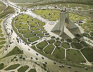
Azadi Square
City square in Tehran, Iran
Distance: Approx. 2479 meters
Latitude and longitude: 35.69972222,51.33722222
Azadi Square (Persian: میدان آزادی Meydāne Āzādi meaning "Freedom Square" or "Liberty Square"), formerly known as Shahyad Square (Persian: میدان شهیاد Meydāne Ŝahyād meaning "Remembrance of [the] Shah Square"), is a mainly green city square in Tehran, Iran. It hosts as its centerpiece the Azadi Tower. The tower and square were commissioned by Mohammad Reza Pahlavi, the last Shah of Iran, to mark the 2,500-year celebration of the Persian Empire.
Pardisan Park
Urban wild park in Tehran, Iran
Distance: Approx. 1879 meters
Latitude and longitude: 35.73333333,51.35
Pardisan Park (Persian: پارک پردیسان – Pārk e Pardisān) is a complex covering more than 270 hectares, located in the northwest of Tehran. It is connected to Hemmat Expressway in the north, and to Sheikh Nouri Expressway in the east.

Sadeghiyeh
Neighborhood in Tehran, Tehran, Iran
Distance: Approx. 228 meters
Latitude and longitude: 35.72194444,51.33722222
Sadeghiyeh (also Sadeghieh, Sadeqiyeh) (Persian: صادقیه) is a heavily populated district in the West of Tehran, Iran. Also called by its pre-revolutionary name Ariashahr (also Aryashahr) (Persian: آریاشهر), it is one of Tehran's busiest commercial and residential centers. The Sadighiyeh metro station is one of the busiest stations in Tehran where Teheran Metro lines 2 and 5 (Karaj Intercity Train) intersect.
Rah Ahan-e Ekbatan Stadium
Multi-purpose stadium in Tehran, Iran
Distance: Approx. 2354 meters
Latitude and longitude: 35.70833333,51.31472222
The Rah Ahan-e Ekbatan Stadium (Persian: ورزشگاه راهآهن اکباتان) formerly known as Apadana Stadium (Persian: ورزشگاه آپادانا) and Persepolis Stadium (Persian: ورزشگاه پرسپولیس) is a multi-purpose stadium in Tehran, Iran. It is currently used mostly for football matches and is the home stadium of Rah Ahan F.C., who currently play in Iran's Premier Football League.The stadium holds 12,000 people.
Goldis Tower
Commercial center in Tehran, Iran
Distance: Approx. 128 meters
Latitude and longitude: 35.7217,51.3361
Goldis Tower (aka Borj-e Goldis ) (Persian: برج گلدیس) is a shopping center located in the commercial district of Sadeghiyeh (Aryashahr) in west of Tehran, Iran. It is a 13-floors building among which 3 first floors are commercial and the upper 10 floors serve as office use.

Shademan Metro Station
Station of the Tehran Metro
Distance: Approx. 2328 meters
Latitude and longitude: 35.70111111,51.33194444
Shademan Metro Station is a station on Tehran Metro Line 2 and Line 4. It is located in the junction of Azadi Street and Azarbayjan Street. It is between Navvab Metro Station and Sharif University Metro Station.
Daneshgah-e Sharif Metro Station
Station of the Tehran Metro
Distance: Approx. 2476 meters
Latitude and longitude: 35.7058,51.3536
Sharif University Metro Station is a station on Tehran Metro Line 2. It is located at the junction of Sohravard Street and Dr. Habibollah Street.
Tarasht Metro Station
Station of the Tehran Metro
Distance: Approx. 1024 meters
Latitude and longitude: 35.7161,51.3435
Tarasht Metro Station is a station on Tehran Metro Line 2. It is located on Shahid Golab Street. It is between the Sharif University Metro Station and the Sadeghieh (Tehran) Metro Station.
Tehran (Sadeghiyeh) Metro Station
Metro station in Tehran, Iran
Distance: Approx. 577 meters
Latitude and longitude: 35.7178,51.3308
Tehran (Sadeghiyeh) Metro Station is the junction of Tehran Metro Line 2 and Tehran Metro Line 5. It is located in Sadeghiye neighborhood near Mohammad Ali Jenah Expressway and Tehran-Karaj Freeway. It is the west end of Line 2 and the east end of Line 5.
Apadana Residential Complex
Planned town in Tehran Province, Iran
Distance: Approx. 1524 meters
Latitude and longitude: 35.71138889,51.32388889
Apadana Residential Society (Persian: شهرک آپادانا) is a planned residential society in the northwest of well known Azadi square in Tehran, Iran. It is located between Azadi Square and Ekbatan Complex.
Sarem Hospital
Hospital in Ekbatan, Iran
Distance: Approx. 2297 meters
Latitude and longitude: 35.714895,51.310791
Sarem Hospital is a private rural general hospital with a focus on gynecology and infertility. It is located in Ekbatan Town in the west of Tehran, Iran.
National Geoscience Database of Iran
Iranian Geoscience government agency
Distance: Approx. 339 meters
Latitude and longitude: 35.7235136,51.3378799
The National Geoscience Database of Iran (Persian: پایگاه ملی دادههای علوم زمین کشور) or in brief NGDIR is a scientific and research government agency in Iran which works in the field of Geology of Iran and centrally manages Geoscience data. This center was established in 1999 in the field of data collection authority with the aim of managing, preserving and sharing Geoscience data.
Weather in this IP's area
few clouds
24 Celsius
23 Celsius
22 Celsius
24 Celsius
1012 hPa
32 %
1012 hPa
877 hPa
10000 meters
3.09 m/s
150 degree
20 %
05:51:10
18:05:01