Country:
Region:
City:
Latitude and Longitude:
Time Zone:
Postal Code:
IP information under different IP Channel
ip-api
Country
Region
City
ASN
Time Zone
ISP
Blacklist
Proxy
Latitude
Longitude
Postal
Route
Luminati
Country
ASN
Time Zone
Asia/Tehran
ISP
Iran Telecommunication Company PJS
Latitude
Longitude
Postal
IPinfo
Country
Region
City
ASN
Time Zone
ISP
Blacklist
Proxy
Latitude
Longitude
Postal
Route
db-ip
Country
Region
City
ASN
Time Zone
ISP
Blacklist
Proxy
Latitude
Longitude
Postal
Route
ipdata
Country
Region
City
ASN
Time Zone
ISP
Blacklist
Proxy
Latitude
Longitude
Postal
Route
Popular places and events near this IP address

Shiraz University
University in Iran
Distance: Approx. 2824 meters
Latitude and longitude: 29.63974167,52.52675
Shiraz University (Persian: دانشگاه شیراز Dāneshgāh-e-Shirāz, formerly known as Pahlavi University دانشگاه پهلوی Dāneshgāh-e Pahlavi) is a public university located in Shiraz, Fars, Iran, established in 1946. Being one of the oldest and most prestigious modern universities in Iran, Shiraz University is listed among the top three research-oriented schools in the nation according to a ranking of Iranian universities based on scientific output. In the first report of state universities ranking and among almost 70 universities and higher education institutes, Shiraz University is regarded as first-level university.

Shiraz University of Medical Sciences
Distance: Approx. 2301 meters
Latitude and longitude: 29.62995556,52.52367778
Shiraz University of Medical Sciences (SUMS) (Persian: دانشگاه علوم پزشکی شیراز Dāneshgāh-e Olum Pezeshki-e Shirāz) is a public medical school located in Shiraz, Iran. Since its inauguration in 1946, SUMS has always been ranked among top medical schools in Iran. Currently, more than 10,000 students are studying in over 200 different disciplines within 17 schools.

Mohammad Namazi
Iranian businessman
Distance: Approx. 1721 meters
Latitude and longitude: 29.6313,52.5176
Mohammad Namazi was the founder of Namazi Hospital, which he founded in 1955 in Shiraz, Iran. He was born in Kazerun, in 1896. He was a successful merchant who lived in the USA for many years.
Namazi Hospital
Hospital in Shiraz, Iran
Distance: Approx. 1721 meters
Latitude and longitude: 29.6313,52.5176
Namazi Hospital is a prominent hospital in Namazi Square, Shiraz, Iran. It was founded by Mohammad Namazi in 1950. Mohammad Namazi founded this hospital with 22 residential villas for physicians in 1950.

Afif-Abad Garden
Museum complex in Shiraz, Iran
Distance: Approx. 754 meters
Latitude and longitude: 29.62316111,52.49836111
Afif-Abad Garden (Persian: باغ عفیف آباد - Bāq-i Afif-Ābād), originally the Gulshan Garden (Persian: باغ گلشن - Bāq-i Gulshan), is a museum complex in Shiraz, Iran.

Eram Garden
Persian garden in Shiraz, Iran
Distance: Approx. 2546 meters
Latitude and longitude: 29.63583333,52.52527778
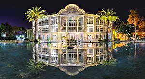
Eram Garden (Persian: باغ ارم, Bāgh-e Eram) is a historic Persian garden in Shiraz, Iran. The garden, and the building within it, are located at the northern shore of the Khoshk River in the Fars province.
Shiraz World Trade Center
Mixed in Shiraz, Iran
Distance: Approx. 816 meters
Latitude and longitude: 29.63,52.50833333
The World Trade Center Shiraz is a mixed-use development project currently under construction in Shiraz, Iran.
Paramount Crossroads
Distance: Approx. 2980 meters
Latitude and longitude: 29.619865,52.5285
Paramount Crossroads (Persian: چهارراه پارامونت, Cahârrâh-e Pârâmont), also known as 15 Khordad Crossroads (Persian: چهارراه پانزده خرداد, Cahârrâh-e Pânzdah-e Xordâd), is a major intersection in a heavily traveled and central area in Shiraz, Iran. It is the junction of Enqelab-e Eslami Street, Lotfali Khan Street and Qasrodasht Street. There is a fuel station docked on the intersection and Zaytoon Shopping Center is in the immediate area.
Mahdiyeh, Fars
Village in Fars, Iran
Distance: Approx. 2018 meters
Latitude and longitude: 29.64472222,52.48805556
Mahdiyeh (Persian: مهديه, also Romanized as Mahdīyeh; also known as Mehdīābād) is a village in Derak Rural District, in the Central District of Shiraz County, Fars Province, Iran. At the 2006 census, its population was 2,206, in 533 families.
Shohada-ye Haftom-e Tir Stadium (Babol)
Distance: Approx. 3550 meters
Latitude and longitude: 29.61666667,52.53333333
Shohada-ye Haftom-e Tir Stadium of Babol is a stadium on Babol, Iran. It is owned by the government Physical Education Organization and has a seating capacity of 6,000. Its primary tenant is F.C. Rayka Babol.

Church of St. Simon the Zealot
Iranian national heritage site
Distance: Approx. 3559 meters
Latitude and longitude: 29.61988272,52.53486961
Church of Simon the Zealot, is an Anglican church in Shiraz, Iran. It is located on Zand Avenue in Shiraz, next to Shiraz Christian Mission Hospital.
1853 Shiraz earthquake
Earthquake in Iran
Distance: Approx. 3317 meters
Latitude and longitude: 29.6,52.5
The Fars region of Iran was struck by a major earthquake on either 22 April or 5 May 1853. The city of Shiraz and the surrounding area were severely affected, with almost all buildings destroyed. At least 9,000 people were killed, with some estimates reaching 13,000.
Weather in this IP's area
few clouds
26 Celsius
26 Celsius
26 Celsius
26 Celsius
1015 hPa
24 %
1015 hPa
850 hPa
10000 meters
3.09 m/s
180 degree
20 %
06:18:55
17:08:39