Country:
Region:
City:
Latitude and Longitude:
Time Zone:
Postal Code:
IP information under different IP Channel
ip-api
Country
Region
City
ASN
Time Zone
ISP
Blacklist
Proxy
Latitude
Longitude
Postal
Route
Luminati
Country
ASN
Time Zone
Asia/Tehran
ISP
Iran Telecommunication Company PJS
Latitude
Longitude
Postal
IPinfo
Country
Region
City
ASN
Time Zone
ISP
Blacklist
Proxy
Latitude
Longitude
Postal
Route
db-ip
Country
Region
City
ASN
Time Zone
ISP
Blacklist
Proxy
Latitude
Longitude
Postal
Route
ipdata
Country
Region
City
ASN
Time Zone
ISP
Blacklist
Proxy
Latitude
Longitude
Postal
Route
Popular places and events near this IP address

Shah Cheragh
Funerary monument and mosque in Shiraz, Iran
Distance: Approx. 4336 meters
Latitude and longitude: 29.60961111,52.54330556
Shah Cheragh (Persian: شاه چراغ) is a 12th century funerary monument and religious complex located in Shiraz, Iran. It is centred around the mausoleum of Sayyid Ahmad, the son of Musa al-Kazim, who is known as Shah Cheragh (King of the Light) in local traditions, and hence the building is named as such. The site is the 363rd national monument of Iran.

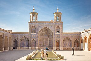
Nasir-ol-Molk Mosque
Mosque in Iran (also known as Pink Mosque)
Distance: Approx. 3851 meters
Latitude and longitude: 29.60861111,52.54833333
The Nasir al-Mulk Mosque (Persian: مسجد نصیرالملک, Masjed-e Nasir ol-Molk), also known as the Pink Mosque (مسجد صورتی, Masjed-e Surati), is a traditional mosque in Shiraz, Iran. It is located near Shāh Chérāgh Mosque. It was built during Qajar dynasty rule of Iran.

Qavam House
Building in Lotf Ali Khan Zand St, Iran
Distance: Approx. 3450 meters
Latitude and longitude: 29.60784444,52.55256944
Qavam House (also widely called, Narenjestan-e Ghavam) is a traditional and historical house and garden in Shiraz, Iran, built between 1879 and 1886. During the second Pahlavi era, the House became the headquarters of Pahlavi University's Asia Institute, directed by Arthur Upham Pope, and later Richard Nelson Frye. The house and gardens are now a museum and are open to the public.

Vakil Bazaar
Building in Shiraz, Iran
Distance: Approx. 4347 meters
Latitude and longitude: 29.61498056,52.54679722
Vakil Bazaar (Persian: بازار وکیل) is a bazaar of Shiraz, Iran, located in the center of the city.

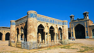
Jameh Mosque of Atigh
Mosque in Shiraz, Fars, Iran
Distance: Approx. 4135 meters
Latitude and longitude: 29.60815,52.5448
Jameh Mosque of Atigh is a 9th-century mosque in Shiraz, the capital of Fars Province, Iran, Atigh Jameh mosque (Atiq Mosque) the oldest mosque of Shiraz was built in celebration of the conquest of Shiraz by Saffarid Amroleiss in the year 276 AH and was completed in 281 AH. It has been restored many times. The height of the building and its various nocturnal areas (Shabestans) with beautiful tile work on the ceilings, gives a unique charm to this place. It is located in the east of Shah Cheragh Shrine.
12 Farvardin Square (Shiraz)
Distance: Approx. 3855 meters
Latitude and longitude: 29.5915,52.5438
12 Farvardin Square is a square in southern Shiraz, Iran, where Jannat Street (Shishegari) and Artesh Boulevard meet each other. Fahmideh Square is to the west, and Rahmat Highway to the south.
Valiasr Square (Shiraz)
Main square in Shiraz, Fars, Iran
Distance: Approx. 2971 meters
Latitude and longitude: 29.6082,52.5587
Valiasr Square (Persian: میدان (فلکه) ولیعصر) is one of the main squares in Shiraz, Fars, Iran. Valiasr Square is the terminus of Salman Farsi (Pirnia) Boulevard, Zand Boulevard and Modares Boulevard. There is an urban bus terminal and a subway station which is under construction in this square.

Delgosha Garden
Distance: Approx. 3127 meters
Latitude and longitude: 29.6197,52.5751
Delgosha Garden (Persian: باغ دلگشا) is one of the historical gardens in Shiraz, Iran near Tomb of Sa’di and it belongs to the pre-Islamic era of the Sassanian Empire. Between Nader Shah period and Zandieh dynasty, this garden suffered a lot of damage and was rebuilt during the reign of Karim Khan Zand. The water that flows from the aqueduct spring of Saadi's tomb passes through this garden Delgosha Garden is located in the northeastern part of Shiraz, on the southern side of Tang Ab Khan, at the foot of a mountain.

Shiraz University of Arts
Distance: Approx. 4305 meters
Latitude and longitude: 29.62488889,52.55912222
Shiraz University of Arts (Persian: دانشگاه هنر شيراز) is the fourth university of arts in Iran and the first in the southern part of the country.

Qasre Abunasr
Distance: Approx. 4081 meters
Latitude and longitude: 29.584122,52.624617
Qaṣr-i Abu Naṣr (Persian: قصر ابونصر, lit. Abu-Naṣr Palace), Qasre Abunasr, or Takht-e Sulayman (Persian: تخت سلیمان, lit. Throne of Solomon) is the site of an ancient settlement situated in city of Shiraz in the Fars province of Iran.

Tomb of Saadi
Monument in Shiraz, Iran
Distance: Approx. 3332 meters
Latitude and longitude: 29.62252778,52.58313889
The Tomb of Saadi, commonly known as Saadieh (Persian: سعدیه), is a tomb and mausoleum dedicated to the Persian poet Saadi in the Iranian city of Shiraz. Saadi was buried at the end of his life at a Khanqah at the current location. In the 13th century, a tomb was built for Saadi by Shams al-Din Juvayni, the vizir of Abaqa Khan.

Tomb of Seyed Alaeddin Husayn
Funerary monument and mosque in Shiraz, Iran
Distance: Approx. 3665 meters
Latitude and longitude: 29.60530556,52.54866667
The tomb of Sayyid ʿAlāʾed-Dīn Ḥusayn (Persian: آرامگاه سَیِّد عَلَاء ٱلدِّیْن حُسَیْن) is a shrine in south-east Shiraz, Iran. Constructed in the 10th century of the Islamic calendar, the mausoleum houses the remains of Sayyid Ala'ed-Din Husayn, son of Imam Musa al-Kazim, and brother of Sayyid Ahmad (whose shrine is also in Shiraz). On account of the instability of the soil, and the earthquakes that occurred in Shiraz, this building suffered considerable damage, and a part of the dome, which had last been repaired by the late Mirza Abu'l-Hasan Moshiro'l-molk, gave way, and was threatened with collapse, and in spite of repairs, and much reinforcement, and subsequently, the threat of dissolution increased daily, until in the year 1950 the dome was taken down by the Fars Department of Education.
Weather in this IP's area
few clouds
26 Celsius
25 Celsius
26 Celsius
26 Celsius
1015 hPa
25 %
1015 hPa
856 hPa
10000 meters
20 %
06:18:32
17:08:22