Country:
Region:
City:
Latitude and Longitude:
Time Zone:
Postal Code:
IP information under different IP Channel
ip-api
Country
Region
City
ASN
Time Zone
ISP
Blacklist
Proxy
Latitude
Longitude
Postal
Route
Luminati
Country
ASN
Time Zone
Asia/Tehran
ISP
Iran Telecommunication Company PJS
Latitude
Longitude
Postal
IPinfo
Country
Region
City
ASN
Time Zone
ISP
Blacklist
Proxy
Latitude
Longitude
Postal
Route
db-ip
Country
Region
City
ASN
Time Zone
ISP
Blacklist
Proxy
Latitude
Longitude
Postal
Route
ipdata
Country
Region
City
ASN
Time Zone
ISP
Blacklist
Proxy
Latitude
Longitude
Postal
Route
Popular places and events near this IP address

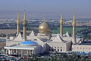
Mausoleum of Ruhollah Khomeini
Memorial in Tehran, Iran
Distance: Approx. 920 meters
Latitude and longitude: 35.5492,51.3665
The mausoleum of Ruhollah Khomeini (Persian: آرامگاه روحالله خمینی) houses the tombs of Ayatollah Ruhollah Khomeini, his wife Khadijeh Saqafi, and his second son Ahmad Khomeini; and some political figures, such as former President Akbar Hashemi Rafsanjani, former Vice President Hassan Habibi, Lieutenant General Ali Sayad Shirazi, Iranian Revolution figure Sadeq Tabatabaei, and MP Marzieh Hadidchi. The mausoleum is located to the south of Tehran in the Behesht-e Zahra (Paradise of Zahra) cemetery. Construction commenced in 1989 following Khomeini's death on June 3 of that year.

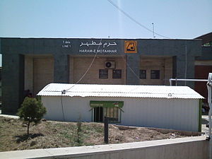
Haram-e Motahhar-e Emam Khomeini Metro Station
Station of the Tehran Metro
Distance: Approx. 1664 meters
Latitude and longitude: 35.54510556,51.37298333
Haram-e Motahhar-e Emam Khomeini Metro station, formerly simply called Haram-e Motahhar Metro Station, is a station of Tehran Metro Line 1. The next station is Shahed - Bagher Shahr on the north side and Kahrizak on the south side. It is located east of Mausoleum of Khomeini.

Shahed - Bagher Shahr Metro Station
Station of the Tehran Metro
Distance: Approx. 2311 meters
Latitude and longitude: 35.54744722,51.38258333
Shahed - Bagher Shahr Metro Station is a station in Tehran Metro Line 1. It is between Haram-e Motahhar Metro Station and Palayeshgah Metro Station. It is located north of Behesht-e Zahra beside Northern Behesht-e Zahra Expressway.
Aftab District
District in Tehran province, Iran
Distance: Approx. 2171 meters
Latitude and longitude: 35.56583333,51.33916667
Aftab District (Persian: بخش آفتاب) is in Tehran County, Tehran province, Iran. Its capital is the village of Aftab.
Aftab, Iran
Village in Tehran province, Iran
Distance: Approx. 1340 meters
Latitude and longitude: 35.54888889,51.34527778
Aftab (Persian: آفتاب) is a village in Aftab Rural District of Aftab District of Tehran County, Tehran province, Iran, serving as capital of both the district and the rural district.
Nematabad-e Ghar
Village in Tehran, Iran
Distance: Approx. 1479 meters
Latitude and longitude: 35.55583333,51.37472222
Nematabad-e Ghar (Persian: نعمت ابادغار, also Romanized as Ne‘matābād-e Ghār and Ne‘matābād-e Chār; also known as Sa‘īdābād) is a village in Aftab Rural District, Aftab District, Tehran County, Tehran Province, Iran. At the 2006 census, its population was 62, in 15 families.
Rashidabad, Tehran
Village in Tehran, Iran
Distance: Approx. 2206 meters
Latitude and longitude: 35.56361111,51.38
Rashidabad (Persian: رشيداباد, also Romanized as Rashīdābād) is a village in Aftab Rural District, Aftab District, Tehran County, Tehran Province, Iran. At the 2006 census, its population was 60, in 14 families.
Dinarabad, Tehran
Village in Tehran, Iran
Distance: Approx. 2182 meters
Latitude and longitude: 35.55861111,51.335
Dinarabad (Persian: ديناراباد, also Romanized as Dīnārābād) is a village in Khalazir Rural District, Aftab District, Tehran County, Tehran Province, Iran. At the 2006 census, its population was 116, in 28 families.
Valiabad, Tehran
Village in Tehran, Iran
Distance: Approx. 2590 meters
Latitude and longitude: 35.57277778,51.34111111
Valiabad (Persian: ولي اباد, also Romanized as Valīābād) is a village in Khalazir Rural District, Aftab District, Tehran County, Tehran Province, Iran. At the 2006 census, its population was 31, in 9 families.
Beheshti, Tehran
Village in Tehran, Iran
Distance: Approx. 2397 meters
Latitude and longitude: 35.53694444,51.37416667
Beheshti (Persian: بهشتي, also Romanized as Beheshtī; also known as Behesht-e Zahrā) is a village in Azimiyeh Rural District, in the Central District of Ray County, Tehran Province, Iran. At the 2006 census, its population was 8,569, in 2,262 families. Behesht-e Zahra cemetery is located nearby.
Qaleh Sangi, Tehran
Village in Tehran, Iran
Distance: Approx. 3165 meters
Latitude and longitude: 35.52666667,51.35027778
Qaleh Sangi (Persian: قلعه سنگي, also Romanized as Qal‘eh Sangī and Qal‘eh-ye Sangī) is a village in Kahrizak Rural District, Kahrizak District, Ray County, Tehran Province, Iran. At the 2006 census, its population was 758, in 191 families.

Shahr-e Aftab Metro Station
Station of the Tehran Metro
Distance: Approx. 1178 meters
Latitude and longitude: 35.54555556,51.36583333
Shahr-e Aftab Metro Station is a station in Tehran Metro Line 1. It is located in Aftab Rural District, near Behesht-e Zahra. The station serves Shahr-e Aftab Expo and Shahed University.
Weather in this IP's area
scattered clouds
18 Celsius
16 Celsius
17 Celsius
20 Celsius
1022 hPa
31 %
1022 hPa
906 hPa
10000 meters
40 %
06:33:22
17:03:20