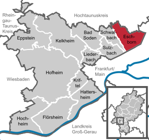
Country:
Region:
City:
Latitude and Longitude:
Time Zone:
Postal Code:
IP information under different IP Channel
ip-api
Country
Region
City
ASN
Time Zone
ISP
Blacklist
Proxy
Latitude
Longitude
Postal
Route
Luminati
Country
Region
he
City
frankfurtammain
ASN
Time Zone
Europe/Berlin
ISP
Vodafone GmbH
Latitude
Longitude
Postal
IPinfo
Country
Region
City
ASN
Time Zone
ISP
Blacklist
Proxy
Latitude
Longitude
Postal
Route
db-ip
Country
Region
City
ASN
Time Zone
ISP
Blacklist
Proxy
Latitude
Longitude
Postal
Route
ipdata
Country
Region
City
ASN
Time Zone
ISP
Blacklist
Proxy
Latitude
Longitude
Postal
Route
Popular places and events near this IP address

Eschborn
Town in Hesse, Germany
Distance: Approx. 1209 meters
Latitude and longitude: 50.14361111,8.57
Eschborn (German pronunciation: [ˈɛʃbɔʁn] ) is a town in the Main-Taunus district, Hesse, Germany. It is part of the Frankfurt Rhein-Main urban area and has a population of 21,488 (2018). Eschborn is home to numerous corporations due to its proximity to Frankfurt and relatively low business tax rate.

Praunheim
Quarter of Frankfurt am Main in Hesse, Germany
Distance: Approx. 2495 meters
Latitude and longitude: 50.13166667,8.60972222
Praunheim is a quarter of Frankfurt am Main, Germany. It is part of the Ortsbezirk Mitte-West and is subdivided into five Stadtbezirke: Praunheim, Praunheim-Nord, Praunheim-Süd, Alt-Praunheim and Westhausen. It is located along the north bank of the river Nidda and is composed of two areas: Alt Praunheim (old Praunheim), a typical Hessian village with a central commercial street and some timber beam houses, located to the east and the Siedlung Praunheim, a residential development built in the 1920s under the auspices of town planner Ernst May located to the west.

Rödelheim
Quarter of Frankfurt am Main in Hesse, Germany
Distance: Approx. 2495 meters
Latitude and longitude: 50.13166667,8.60972222
Rödelheim is a quarter of Frankfurt am Main, Germany. It is part of the Ortsbezirk Mitte-West and is subdivided into the Stadtbezirke Rödelheim-Ost and Rödelheim-West. There are a number of celebrities who have established their base in Rödelheim, including Rödelheim Hartreim Projekt, Mathias Barbosa and Sabrina Setlur.

Sossenheim
Quarter of Frankfurt am Main in Hesse, Germany
Distance: Approx. 1718 meters
Latitude and longitude: 50.11888889,8.56583333
Sossenheim is a quarter of Frankfurt am Main, Germany. It is part of the Ortsbezirk West and is subdivided into the Stadtbezirke Sossenheim-Ost and Sossenheim-West. Sossenheim has been a district of Frankfurt since 1928 and makes part of the northwest border of the city.
1. FC Eschborn
German football club
Distance: Approx. 1270 meters
Latitude and longitude: 50.14,8.56055556
1. FC Eschborn was a German association football club which played in Eschborn, a town close to Frankfurt, Hesse.
Au (squat)
Squatted building in Frankfurt, Germany
Distance: Approx. 2185 meters
Latitude and longitude: 50.12166111,8.59960278
Au is the name of a building that has been squatted since 1983 in Rödelheim in Frankfurt, Germany. It bills itself as a 'self-organised cultural Centre and living project' (German: Selbstverwaltetes Kulturelles Zentrum und Wohnprojekt). Au was home to the Au Squat Festival on June 3, 2006, featuring many punk rock bands such as The Restarts.

Arboretum Main-Taunus
Distance: Approx. 2060 meters
Latitude and longitude: 50.135,8.54611111
The Arboretum Main-Taunus is an arboretum on an area of 76 hectares (190 acres) located southwest of Eschborn, Hesse, Germany. The arboretum lies close to Frankfurt am Main.

Frankfurt-Rödelheim station
Railway station in Frankfurt, Germany
Distance: Approx. 2508 meters
Latitude and longitude: 50.12444444,8.60722222
Frankfurt-Rödelheim station is a regional and S-Bahn station in western Frankfurt am Main, Germany on the Homburg line, in the district of Rödelheim. The Kronberg line branches off the Homburg line north of the station. The junction with the Rebstock curve of the former Bad Nauheim–Wiesbaden line (Bäderbahn) is south of the station.
Schwalbach (Sulzbach)
River in Germany
Distance: Approx. 2474 meters
Latitude and longitude: 50.12888889,8.54083333
Schwalbach is a river of Hesse, Germany. It is formed in Schwalbach am Taunus at the confluence of the rivers Sauerbornsbach and Waldbach. It is a left tributary of the Sulzbach, into which it flows near Sulzbach.

Lycée français Victor Hugo
School in Frankfurt, Hesse, Germany
Distance: Approx. 2368 meters
Latitude and longitude: 50.134563,8.607964
Lycée français Victor-Hugo (LFVH), also known as Französische Schule Lycee Victor Hugo in German, is a French international school in Frankfurt am Main, Germany It is directly operated by the Agency for French Education Abroad (AEFE), an agency of the French government. The school serves students from "maternelle" (kindergarten) up to the "lycée" (sixth form college/senior high school) level. The French school is located in the district of Praunheim, to the northwest of Frankfurt.
Reisebank
German bank
Distance: Approx. 2147 meters
Latitude and longitude: 50.127575,8.603614
ReiseBank AG is a bank specializing in foreign currency dealing, precious metals and travel payment business (including traveler's checks), which is headquartered in Frankfurt am Main. It is a wholly owned subsidiary of DZ Bank and part of the cooperative financial group.

Nordwestkreuz Frankfurt
Road junction
Distance: Approx. 1166 meters
Latitude and longitude: 50.13416667,8.59111111
The Nordwestkreuz Frankfurt is a cloverleaf interchange in Frankfurt. Here, the Bundesautobahn 5 (Hattenbacher Dreieck - Frankfurt am Main - Basel) and the Bundesautobahn 66 (Wiesbaden - Fulda) intersect. Roadways and bridges to L3005 from Rödelheim to Eschborn are also integrated into the interchange.
Weather in this IP's area
fog
2 Celsius
2 Celsius
1 Celsius
5 Celsius
1026 hPa
92 %
1026 hPa
1011 hPa
10000 meters
0.51 m/s
18 %
07:22:49
16:55:46
