Country:
 USA
USARegion:
City:
Latitude and Longitude:
Time Zone:
Postal Code:
IP information under different IP Channel
ip-api
Country
Region
City
ASN
Time Zone
ISP
Blacklist
Proxy
Latitude
Longitude
Postal
Route
IPinfo
Country
Region
City
ASN
Time Zone
ISP
Blacklist
Proxy
Latitude
Longitude
Postal
Route
MaxMind
Country
Region
City
ASN
Time Zone
ISP
Blacklist
Proxy
Latitude
Longitude
Postal
Route
Luminati
Country
USASN
Time Zone
America/Chicago
ISP
UNITAS
Latitude
Longitude
Postal
db-ip
Country
Region
City
ASN
Time Zone
ISP
Blacklist
Proxy
Latitude
Longitude
Postal
Route
ipdata
Country
Region
City
ASN
Time Zone
ISP
Blacklist
Proxy
Latitude
Longitude
Postal
Route
Popular places and events near this IP address

United States District Court for the District of Rhode Island
United States district court
Distance: Approx. 139 meters
Latitude and longitude: 41.825811,-71.410454
The United States District Court for the District of Rhode Island (in case citations, D.R.I.) is the federal district court whose jurisdiction is the state of Rhode Island. The District Court was created in 1790 when Rhode Island ratified the Constitution. The Federal Courthouse was built in 1908.

WWBB
Radio station in Rhode Island, United States
Distance: Approx. 72 meters
Latitude and longitude: 41.82522222,-71.41005556
WWBB (101.5 FM, "B101") is a radio station in Providence, Rhode Island, United States. The station plays classic hits from the 1970s, 1980s and 1990s. WWBB's offices and studios are located on Oxford Street in Providence, on the 3rd and 4th floors of the Roland Building near Interstate 95.

Industrial National Bank Building
Vacant skyscraper in Providence, Rhode Island, US
Distance: Approx. 122 meters
Latitude and longitude: 41.824553,-71.410696
The Industrial Trust Building, located at 111 Westminster Street or 55 Kennedy Plaza in downtown Providence, Rhode Island, was built in 1928 as the Industrial Trust Co. Building, and was designed by the New York firm of Walker & Gillette. At 428 feet (130 m) with 26 floors, it is the tallest building in Providence and the state of Rhode Island, and the 28th tallest in New England; when it was completed it stood several stories higher than the recently finished Biltmore Hotel nearby.
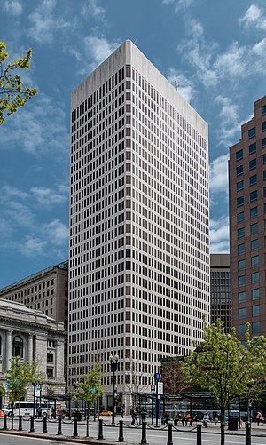
One Financial Plaza (Providence)
Office in RI , United States
Distance: Approx. 76 meters
Latitude and longitude: 41.82530833,-71.41003889
One Financial Plaza, also known as the Sovereign Bank Tower and formerly known as the Hospital Trust Tower, is an international-style skyscraper that stands along Kennedy Plaza in Downtown Providence, Rhode Island. The building is the second-tallest in the city and state, surpassed in height only by the Industrial National Bank Building.

Textron Tower
International-style skyscraper in downtown Providence, Rhode Island
Distance: Approx. 20 meters
Latitude and longitude: 41.825,-71.4091
The Textron Tower, formerly the Old Stone Tower, is a modern skyscraper in downtown Providence, Rhode Island. It is the world headquarters of Textron. At 311 ft (95 m), the Textron Tower stands as the 5th-tallest building in the city and the state.

50 Kennedy Plaza
Office in Rhode Island, United States
Distance: Approx. 100 meters
Latitude and longitude: 41.8248,-71.4105
50 Kennedy Plaza (formerly known as Fleet Center) is a postmodern skyscraper in Providence, Rhode Island. At a height of 285 ft (87 m), it is currently the sixth-tallest building in the city and state. The building is named for Kennedy Plaza, which stands to the structure's northeast.

Turk's Head Building
Office in RI , United States
Distance: Approx. 60 meters
Latitude and longitude: 41.82456111,-71.40986111
The Turk's Head Building is a 16-story office high-rise in Providence, Rhode Island. When completed in 1913, the Turk's Head Building surpassed the 1901 Union Trust Company Building to become the tallest building in downtown (the Rhode Island State House is taller and was finished in 1904). The building retained that title until 1922, when the Providence Biltmore was completed.

Customhouse Historic District
Historic district in Rhode Island, United States
Distance: Approx. 89 meters
Latitude and longitude: 41.82416667,-71.40972222
The Customhouse Historic District is a historic district encompassing fifteen historic buildings in downtown Providence, Rhode Island. The district is bounded by Westminster, Exchange, Dyer, Pine, and Peck Streets, and includes eight buildings associated with the important functions of the business center Providence became in the mid-to-late 19th century. It was listed on the National Register of Historic Places in 1975, and is completely contained within the Downtown Providence Historic District, listed in 1984.

Market House (Providence, Rhode Island)
United States historic place
Distance: Approx. 129 meters
Latitude and longitude: 41.82581,-71.40833
The Market House is a historic three-story brick market house in Market Square, in the College Hill, a neighborhood of Providence, Rhode Island, USA. The building was constructed between 1773 and 1775 and designed by prominent local architects, Joseph Brown and Declaration of Independence signer Stephen Hopkins. The bottom floor of the house was used as a market, and the upper level was used for holding meetings. Similar buildings existed in other American cities, such as Faneuil Hall in Boston and the Old Brick Market in Newport.

Merchants Bank Building (Providence, Rhode Island)
United States historic place
Distance: Approx. 61 meters
Latitude and longitude: 41.82472222,-71.41
The Merchants Bank Building is a historic commercial building at 32 Westminster Street in downtown Providence, Rhode Island. It is a six-story brownstone structure, designed by Alpheus C. Morse and Clifton A. Hall and built in 1855–57. When built, this Italianate structure was one of the first buildings of Providence's financial district, and is now surrounded by much larger modern skyscrapers.

Rhode Island Hospital Trust Building
Historic place in Providence, Rhode Island
Distance: Approx. 91 meters
Latitude and longitude: 41.82527778,-71.41027778
The Rhode Island Hospital Trust Building is an historic commercial building in downtown Providence, Rhode Island, United States, designed by York & Sawyer.
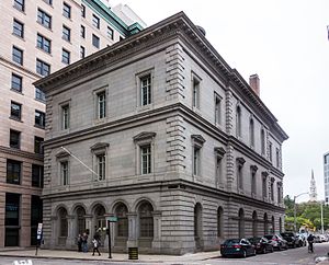
United States Customshouse (Providence, Rhode Island)
United States historic place
Distance: Approx. 77 meters
Latitude and longitude: 41.82444444,-71.41
The U.S. Customshouse is a historic custom house at 24 Weybosset Street in Providence, Rhode Island at the northeast corner at Weybosset and Custom House streets. The customhouse was built between 1855 and 1857 to a design by Ammi B. Young and added to the National Register of Historic Places in 1972. In 1992, the building was purchased by the State of Rhode Island and converted to office space for the State Courts System.
Weather in this IP's area
clear sky
5 Celsius
4 Celsius
4 Celsius
7 Celsius
1033 hPa
91 %
1033 hPa
1030 hPa
10000 meters
1.61 m/s
1.92 m/s
345 degree
07:02:50
17:57:51