Country:
Region:
City:
Latitude and Longitude:
Time Zone:
Postal Code:
IP information under different IP Channel
ip-api
Country
Region
City
ASN
Time Zone
ISP
Blacklist
Proxy
Latitude
Longitude
Postal
Route
Luminati
Country
Region
33
City
shuku
ASN
Time Zone
Asia/Tokyo
ISP
Okayama University of Science
Latitude
Longitude
Postal
IPinfo
Country
Region
City
ASN
Time Zone
ISP
Blacklist
Proxy
Latitude
Longitude
Postal
Route
db-ip
Country
Region
City
ASN
Time Zone
ISP
Blacklist
Proxy
Latitude
Longitude
Postal
Route
ipdata
Country
Region
City
ASN
Time Zone
ISP
Blacklist
Proxy
Latitude
Longitude
Postal
Route
Popular places and events near this IP address

Sōja
City in Chūgoku, Japan
Distance: Approx. 3985 meters
Latitude and longitude: 34.67277778,133.74638889
Sōja (総社市, Sōja-shi) is a city located in Okayama Prefecture, Japan. As of 31 March 2023, the city had an estimated population of 69,428 and a population density of 330 persons per km². The total area of the city is 211.90 square kilometres (81.82 sq mi).

Okayama Prefectural University
Distance: Approx. 3796 meters
Latitude and longitude: 34.69222222,133.78194444
Okayama Prefectural University (岡山県立大学, Okayama Kenritsu Daigaku) is a public university in Sōja, Okayama, Japan, established in 1993.
Kawasaki University of Medical Welfare
Distance: Approx. 3478 meters
Latitude and longitude: 34.63472222,133.81111111
Kawasaki University of Medical Welfare (川崎医療福祉大学, Kawasaki iryō fukushi daigaku) is a private university in Kurashiki, Okayama, Japan, established in 1991.
Kawasaki Medical School
University in Kurashiki, Japan
Distance: Approx. 3733 meters
Latitude and longitude: 34.63194444,133.81138889
Kawasaki Medical School (川崎医科大学, Kawasaki ika daigaku) is a private university in Kurashiki, Japan, established in April 1970.

Kawasaki College of Allied Health Professions
Distance: Approx. 3750 meters
Latitude and longitude: 34.63394444,133.81447222
Kawasaki College of Allied Health Professions (川崎医療短期大学, Kawasaki iryō tanki daigaku) is a private junior college in Kurashiki, Okayama, Japan, established in 1973.

Hattori Station (Okayama)
Railway station in Sōja, Okayama Prefecture, Japan
Distance: Approx. 3787 meters
Latitude and longitude: 34.69109167,133.77516389
Hattori Station (服部駅, Hattori-eki) is a passenger railway station located in the city of Sōja, Okayama Prefecture, Japan. It is operated by West Japan Railway Company (JR West).

Higashi-Sōja Station
Railway station in Sōja, Okayama Prefecture, Japan
Distance: Approx. 3841 meters
Latitude and longitude: 34.67763333,133.75143611
Higashi-Sōja Station (東総社駅, Higashi-Sōja-eki) is a passenger railway station located in the city of Sōja, Okayama Prefecture, Japan. It is operated by West Japan Railway Company (JR West).

Tatetsuki Site
Distance: Approx. 3637 meters
Latitude and longitude: 34.66305556,133.82548611
Tatetsuki Site (楯築遺跡, Tatetsuki Iseki) is a Yayoi period burial mound, located in the Yabe neighborhood of the city of Kurashiki, Okayama Prefecture, in the San'yō region of Japan. The tumulus was designated a National Historic Site of Japan in 1981. It is one of the largest Yayoi period graves in Japan.

Tsukuriyama Kofun (Okayama)
Distance: Approx. 2355 meters
Latitude and longitude: 34.67378611,133.80370833
Tsukuriyama Kofun (造山古墳) is a cluster of Kofun period burial mounds located in the Shinjōshita neighborhood of Kita-ku, Okayama, Okayama Prefecture, in the San'yō region of Japan. The cluster was designated a National Historic Site of Japan in 1921. The main Tsukuriyama Kofun is the largest burial mound in Okayama Prefecture and the fourth largest in Japan.

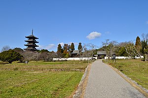
Bitchū Kokubun-ji
Historic religious ruin in Sōja, Okayama, Japan
Distance: Approx. 975 meters
Latitude and longitude: 34.66641111,133.78215833
The Bitchū Kokubun-ji (備中国分寺) is an Omuro-branch Shingon Buddhist temple located in what is now the Kamibayashi neighborhood of the city of Sōja, Japan. Its main image is a statue of Yakushi Nyorai. It claims to be the successor to one of the provincial temples per the system established by Emperor Shōmu during the Nara period (710 – 794) for the purpose of promoting Buddhism as the national religion of Japan and standardising imperial rule over the provinces.

Kōmorizuka Kofun
Distance: Approx. 1036 meters
Latitude and longitude: 34.66759722,133.78660833
Kōmorizuka Kofun (こうもり塚古墳) is a Kofun period burial mound, located in the Kanbayashi neighborhood of the city of Sōja, Okayama Prefecture, in the San'yō region of Japan. The tumulus was designated a National Historic Site of Japan in 1968. It was formerly known as the Kurohimezuka Kofun (黒姫塚古墳).

Tsukuriyama Kofun (Sōja)
Distance: Approx. 1703 meters
Latitude and longitude: 34.66421667,133.76903333
Tsukuriyama Kofun (作山古墳) is a Kofun period burial mound located in the Misu neighborhood of Sōja, Okayama Prefecture, in the San'yō region of Japan. The tumulus was designated a National Historic Site of Japan in 1921. It is the second largest tumulus in Okayama Prefecture and the tenth largest in Japan, and is estimated to have been built in the middle of the 5th century (in the middle of the Kofun period).
Weather in this IP's area
overcast clouds
18 Celsius
17 Celsius
17 Celsius
18 Celsius
1019 hPa
82 %
1019 hPa
1014 hPa
10000 meters
1.98 m/s
2.75 m/s
25 degree
100 %
06:39:39
16:59:50

