150.242.23.24 - IP Lookup: Free IP Address Lookup, Postal Code Lookup, IP Location Lookup, IP ASN, Public IP
Country:
Region:
City:
Location:
Time Zone:
Postal Code:
IP information under different IP Channel
ip-api
Country
Region
City
ASN
Time Zone
ISP
Blacklist
Proxy
Latitude
Longitude
Postal
Route
Luminati
Country
ASN
Time Zone
Asia/Kolkata
ISP
Kings Broadband Pvt Ltd
Latitude
Longitude
Postal
IPinfo
Country
Region
City
ASN
Time Zone
ISP
Blacklist
Proxy
Latitude
Longitude
Postal
Route
IP2Location
150.242.23.24Country
Region
kerala
City
thiruvananthapuram
Time Zone
Asia/Kolkata
ISP
Language
User-Agent
Latitude
Longitude
Postal
db-ip
Country
Region
City
ASN
Time Zone
ISP
Blacklist
Proxy
Latitude
Longitude
Postal
Route
ipdata
Country
Region
City
ASN
Time Zone
ISP
Blacklist
Proxy
Latitude
Longitude
Postal
Route
Popular places and events near this IP address

Thiruvananthapuram International Airport
International airport in Kerala, India
Distance: Approx. 517 meters
Latitude and longitude: 8.48,76.92
Thiruvananthapuram International Airport (IATA: TRV, ICAO: VOTV), is an international airport that serves Thiruvananthapuram, the capital city of Kerala, India. Established in 1932, it is the first airport in the state of Kerala and the fifth international airport of India, officially declared in 1991. It is the operating base of Air India and Air India Express.

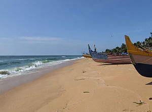
Shankumugham Beach
Important beach in Trivandrum
Distance: Approx. 534 meters
Latitude and longitude: 8.4811295,76.9123703
Shankumugham Beach is a beach in Thiruvananthapuram district of Kerala, south India. The beach is on the western side of Thiruvananthapuram and is very close to Thiruvananthapuram International Airport. Shanghumugham beach is considered as the ‘Arattukadavu’ of Sri Ananthapadmanabhan - the presiding deity of the city.

Vettucaud
Suburb in Thiruvananthapuram, Kerala, India
Distance: Approx. 1839 meters
Latitude and longitude: 8.48333333,76.9
Vettucaud is located on the north-west coast of Thiruvananthapuram. The Madre de deus church vettukad is situated here. This church is popularly known as Vettucaud Palli.

Valiathura
Suburb in Thiruvananthapuram, Kerala, India
Distance: Approx. 2399 meters
Latitude and longitude: 8.46305556,76.92416667
Valiathura' was a major port of Thiruvananthapuram city, the capital of Kerala, India. It is one of the oldest ports in India. This was once the only port along the South Kerala coast.
Pettah, Thiruvananthapuram
Urban Neighbourhood in Thiruvananthapuram, Kerala, India
Distance: Approx. 1892 meters
Latitude and longitude: 8.495,76.92916667
Pettah is an urban neighbourhood of Thiruvananthapuram, the capital of the Indian state of Kerala. Strategically located near the Thiruvananthapuram International Airport and along the main road connecting key city areas, Pettah has historically served as a gateway to the city. Its proximity to the renowned Padmanabhaswamy Temple made it a favored destination for traders and pilgrims alike.

Anchuthengu
Historic site in Thiruvananthapuram, India
Distance: Approx. 0 meters
Latitude and longitude: 8.4833,76.9167
Anchuthengu ("Five Coconut Palms"), formerly known as Anjengo, Angengo or Anjenga, is a coastal panchayath and town in the Thiruvananthapuram District of Kerala. It is situated 9 km south-west of Varkala Town along Trivandrum - Varkala - Kollam coastal highway. The town contains old Dutch-style churches, a lighthouse, a 100-year-old convent and school, tombs of Dutch and British sailors and soldiers, and the remains of the Anchuthengu Fort.

Mother of God Church, Vettukad
Church in India
Distance: Approx. 2182 meters
Latitude and longitude: 8.49418,76.90021
The Madre de Deus Church, also known as the Mother of God Church ("mother of God" in Portuguese/Latin), is a church located in Vettukad in Kerala, India's Thiruvananthapuram district.
Palkulangara Devi Temple
Hindu temple in Kerala, India
Distance: Approx. 1949 meters
Latitude and longitude: 8.4875,76.93388889
Palkulangara Devi Temple (Malayalam: പാല്കുളങ്ങര ദേവി ക്ഷേത്രം) is a Hindu temple in Palkulangara, Thiruvananthapuram, Kerala, India. This place is around 1 km from Pettah junction, 700 m from West Fort junction and 1.5 km from Chakka bypass junction. It is about 1.5 km to the west of Sree Padmanabhaswamy Temple.
Palkulangara
Town in Kerala, India
Distance: Approx. 1892 meters
Latitude and longitude: 8.495,76.92916667
Palkulangara is an urban neighbourhood of Thiruvananthapuram, the capital of the Indian state of Kerala.
Perunthanni
Town in Kerala, India
Distance: Approx. 1892 meters
Latitude and longitude: 8.495,76.92916667
Perunthanni is a suburb of Thiruvananthapuram, the capital of the Indian state of Kerala. This place is situated on Vetti Muricha Kotta-Westfort-Enchakkal Road.

Mall of Travancore
Shopping mall in Thiruvananthapuram, India
Distance: Approx. 1062 meters
Latitude and longitude: 8.4872,76.9255
Mall of Travancore (MOT) is a shopping mall located in Thiruvananthapuram, Kerala, India. Developed by Malabar Group, it is the first shopping mall in Thiruvananthapuram. The Mall was initiated by Malabar Developers in 2014 and was completed in 2018.
Rajiv Gandhi Academy for Aviation Technology
Flying school in Kerala
Distance: Approx. 705 meters
Latitude and longitude: 8.489599,76.916024
Rajiv Gandhi Academy for Aviation Technology (RAGAAT) is a state-owned pilot training institute run by the Government of Kerala, India. It is situated at the Thiruvananthapuram International Airport. Originally founded as Kerala Flying Club, a private flying club in 1959 by G. V. Raja, it was bought by the state government in 1981.
Weather in this IP's area
mist
27 Celsius
31 Celsius
27 Celsius
27 Celsius
1014 hPa
89 %
1014 hPa
1014 hPa
4000 meters
1.03 m/s
75 %