Country:
 USA
USARegion:
City:
Latitude and Longitude:
Time Zone:
Postal Code:
IP information under different IP Channel
ip-api
Country
Region
City
ASN
Time Zone
ISP
Blacklist
Proxy
Latitude
Longitude
Postal
Route
IPinfo
Country
Region
City
ASN
Time Zone
ISP
Blacklist
Proxy
Latitude
Longitude
Postal
Route
MaxMind
Country
Region
City
ASN
Time Zone
ISP
Blacklist
Proxy
Latitude
Longitude
Postal
Route
Luminati
Country
USRegion
ny
City
newyork
ASN
Time Zone
America/New_York
ISP
Cato Networks Ltd
Latitude
Longitude
Postal
db-ip
Country
Region
City
ASN
Time Zone
ISP
Blacklist
Proxy
Latitude
Longitude
Postal
Route
ipdata
Country
Region
City
ASN
Time Zone
ISP
Blacklist
Proxy
Latitude
Longitude
Postal
Route
Popular places and events near this IP address

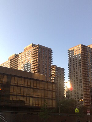
Riverside South, Manhattan
Building complex in New York City
Distance: Approx. 87 meters
Latitude and longitude: 40.778,-73.989
Riverside South is an urban development project in the Lincoln Square neighborhood of the Upper West Side of Manhattan, New York City. It was originated by six civic associations – The Municipal Art Society, Natural Resources Defense Council, New Yorkers for Parks, Regional Plan Association, Riverside Park Fund, and Westpride – in partnership with real estate developer Donald Trump. The largely residential complex, located on the site of a former New York Central Railroad yard, includes Freedom Place and Riverside Center.

Lincoln Square Synagogue
Modern Orthodox synagogue in New York City
Distance: Approx. 581 meters
Latitude and longitude: 40.776872,-73.983248
The Lincoln Square Synagogue is a Modern Orthodox congregation and synagogue located at 180 Amsterdam Avenue between West 68th and 69th Streets in the Lincoln Square neighborhood of Manhattan, New York City. Founded in 1964, the synagogue has moved several times; the most recent move occurred in January 2013. The 2013 building is the largest synagogue built in New York City in over 50 years.

New York Central Railroad 69th Street Transfer Bridge
Historic dock in Manhattan, New York
Distance: Approx. 80 meters
Latitude and longitude: 40.779209,-73.989626
The 69th Street Transfer Bridge, part of the West Side Line of the New York Central Railroad, was a dock for car floats which allowed the transfer of railroad cars from the rail line to car floats which crossed the Hudson River to the Weehawken Yards in New Jersey. Its innovative linkspan design kept the boxcars from falling into the river while being loaded. After it fell into disuse, it was in danger of being torn down and removed, but around the year 2000, during renovations of Riverside Park, following the example of Gantry Plaza State Park, it became a prominent feature of the park.
Lincoln Towers
Distance: Approx. 289 meters
Latitude and longitude: 40.777,-73.987
Lincoln Towers is an apartment complex on the Upper West Side of the New York City borough of Manhattan that consists of six buildings with eight addresses on a 20-acre (81,000 m2) campus.

Septuagesimo Uno
Public park in Manhattan, New York
Distance: Approx. 464 meters
Latitude and longitude: 40.77866667,-73.98430556
Septuagesimo Uno is a 0.04-acre (160 m2) park in the Upper West Side of the New York City borough of Manhattan. It is located on 71st Street between West End Avenue to the west and the intersection of Broadway and Amsterdam Avenue to the east. The park's name is Latin for "seventy-first".

Bradford Hotel (New York City)
Hotel in Manhattan, New York
Distance: Approx. 542 meters
Latitude and longitude: 40.77741667,-73.98352778
The Bradford Hotel is a New York City establishment which opened on October 18, 1924, at 206 - 22 West 70th Street in Manhattan. It cost $2 million to build and was designed by George F. Pelham. It was owned by the Lapidus Engineering Company, the same firm that controlled the Hotel Oxford, which opened in 1923.
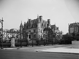
Charles M. Schwab House
Demolished mansion in Manhattan, New York
Distance: Approx. 532 meters
Latitude and longitude: 40.7811,-73.9845
The Charles M. Schwab House (also called Riverside) was a 75-room mansion on Riverside Drive, between 73rd and 74th Streets, on the Upper West Side of Manhattan in New York City. It was constructed for steel magnate Charles M. Schwab. The home was considered to be the classic example of a "white elephant", as it was built on the "wrong" side of Central Park away from the more fashionable Upper East Side.

The Level Club
United States historic place
Distance: Approx. 580 meters
Latitude and longitude: 40.78027778,-73.98333333
The Level Club is a residential building at 253 West 73rd Street on the Upper West Side of Manhattan in New York City. It was built as a men's club by a group of Freemasons in 1927; it served this original function for just about three years. Afterwards, the building was used, in turn, as a hotel and a drug re-hab center.

Eleanor Roosevelt Monument
Sculpture in Manhattan, New York, U.S.
Distance: Approx. 414 meters
Latitude and longitude: 40.78065,-73.98579
The Eleanor Roosevelt Monument is located at the southeast corner of New York City's Riverside Park. It was the first work of public art in New York City to be dedicated to an American woman and, according to the Eleanor Roosevelt Monument Fund, which provided much of the funding for the project, it was the first work of public art to be dedicated to an American president's wife. The centerpiece of the monument is a bronze statue of Eleanor Roosevelt.
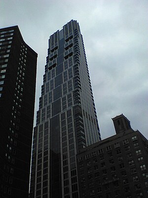
One Riverside Park
Residential skyscraper in Manhattan, New York
Distance: Approx. 506 meters
Latitude and longitude: 40.774117,-73.991373
One Riverside Park is a skyscraper at 40 Riverside Boulevard in Riverside South, on the Upper West Side neighborhood of Manhattan, New York City. Its name was later changed to 50 Riverside Boulevard following media reports related to the development's "poor door". The building consists of 33 floors containing 219 residential units.
Hadar (educational institution)
Jewish institution in New York City
Distance: Approx. 579 meters
Latitude and longitude: 40.776575,-73.983417
Hadar is an educational institution on the Upper West Side of Manhattan. The institute offers various programs to support the development of traditional yet egalitarian Judaism. A major component of the institute is Yeshivat Hadar, which offers both summer and year-long fellowships for students to learn full-time in the yeshiva setting.
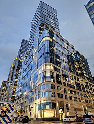
200 Amsterdam
Residential skyscraper under construction in Manhattan, New York
Distance: Approx. 580 meters
Latitude and longitude: 40.7768,-73.9833
200 Amsterdam is a residential skyscraper at the intersection of Amsterdam Avenue and 69th Street on the Upper West Side in Manhattan, New York City. The lot was formerly occupied by the Lincoln Square Synagogue. The tower contains 112 condominiums.
Weather in this IP's area
few clouds
23 Celsius
23 Celsius
22 Celsius
25 Celsius
1008 hPa
44 %
1008 hPa
1007 hPa
10000 meters
6.71 m/s
9.83 m/s
316 degree
20 %
06:58:59
18:28:01