Country:
 USA
USARegion:
City:
Latitude and Longitude:
Time Zone:
Postal Code:
IP information under different IP Channel
ip-api
Country
Region
City
ASN
Time Zone
ISP
Blacklist
Proxy
Latitude
Longitude
Postal
Route
IPinfo
Country
Region
City
ASN
Time Zone
ISP
Blacklist
Proxy
Latitude
Longitude
Postal
Route
MaxMind
Country
Region
City
ASN
Time Zone
ISP
Blacklist
Proxy
Latitude
Longitude
Postal
Route
Luminati
Country
USRegion
co
City
lafayette
ASN
Time Zone
America/Denver
ISP
Cato Networks Ltd
Latitude
Longitude
Postal
db-ip
Country
Region
City
ASN
Time Zone
ISP
Blacklist
Proxy
Latitude
Longitude
Postal
Route
ipdata
Country
Region
City
ASN
Time Zone
ISP
Blacklist
Proxy
Latitude
Longitude
Postal
Route
Popular places and events near this IP address

Lafayette, Colorado
City in Colorado, United States
Distance: Approx. 1077 meters
Latitude and longitude: 40.00333333,-105.10694444
The City of Lafayette ( LA(H)F-ee-ET) is a home rule municipality located in southeastern Boulder County, Colorado, United States. The city population was 30,411 at the 2020 United States Census.

Louisville, Colorado
City in Colorado, United States
Distance: Approx. 4082 meters
Latitude and longitude: 39.97055556,-105.13055556
The City of Louisville ( ) is a home rule municipality located in southeastern Boulder County, Colorado, United States. The city population was 21,226 at the 2020 United States Census. Louisville began as a mining community in 1877, experienced a period of labor violence early in the 20th century, and transitioned to a suburban residential community when the mines closed in the 1950s.
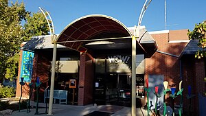
WOW! Children's Museum
Children's museum in Lafayette, Colorado
Distance: Approx. 750 meters
Latitude and longitude: 39.999,-105.089
WOW! Children's Museum, formally World of Wonder, is an interactive children's museum located in Lafayette, Colorado geared toward children under 12. It was founded in 1996 by Lisa and Dario Attallah and in 2004 moved to Lafayette from Louisville.
Peak to Peak Charter School
Charter school in Lafayette, Colorado, United States
Distance: Approx. 1687 meters
Latitude and longitude: 39.99107778,-105.07918611
Peak to Peak Charter School is a K-12 public charter school offering a liberal arts, college-preparatory curriculum. Peak to Peak is located in the Boulder Valley School District (BVSD) in Lafayette, Colorado, United States.
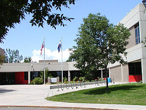
Centaurus High School
Public high school in Lafayette, Colorado, United States
Distance: Approx. 1769 meters
Latitude and longitude: 39.98611111,-105.1125
Centaurus High School (CHS) is a public secondary school in Lafayette, Colorado, United States, serving students in grades nine through twelve. It is part of the Boulder Valley School District and is a School of Opportunity. It offers International Baccalaureate, Advanced Placement, AVID and engineering programs.
Marfell Lakes
Distance: Approx. 2896 meters
Latitude and longitude: 40.0192,-105.0797
The Marfell Lakes (1 and 2) are reservoirs in Boulder County near Lafayette-Louisville in the U.S. state of Colorado. The altitude is 5,223 feet (1,592 m).
Flatirons Community Church
Church in Colorado, United States
Distance: Approx. 1189 meters
Latitude and longitude: 39.9867,-105.0937
Flatirons Community Church is a large non-denominational church in Lafayette, Colorado, approximately 10 miles east of Boulder, Colorado, United States.
Brideun School for Exceptional Children
Elementary school in Lafayette, Colorado, United States
Distance: Approx. 2692 meters
Latitude and longitude: 39.973116,-105.092474
Brideun School for Exceptional Children was a school for twice exceptional (2e) children in Lafayette, Colorado. It operated between 2000 and 2006 and received some national attention. It was the first elementary school in United States specifically founded for 2e students.

Congregational Church (Lafayette, Colorado)
Historic church in Colorado, United States
Distance: Approx. 852 meters
Latitude and longitude: 39.99805556,-105.0875
The Congregational Church at 300 E. Simpson St. in Lafayette, Colorado was listed on the U.S. National Register of Historic Places in 1983 as part of a multiple property submission, the Lafayette Coal Mining Era Buildings TR. It has served as a church, meeting hall, hospital, and library. It has been restored and remodeled for use as the Mary Miller Theater, home of the Theater Company of Lafayette.

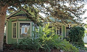
Miller House (Lafayette, Colorado)
United States historic place
Distance: Approx. 993 meters
Latitude and longitude: 39.997475,-105.08577778
The Miller House was built by Lafayette, Colorado's town founder Mary Miller. Miller arrived in Colorado in 1863 and after discovering coal on her land, she opened a mine and in 1888 established the coal town of Lafayette. She made charitable donations to coal mining families and the town.

Ginacci House
Historic house in Colorado, United States
Distance: Approx. 3477 meters
Latitude and longitude: 39.98111111,-105.1325
The Ginacci House, at 1116 LaFarge St. in Louisville, Colorado, was built around 1908. It was listed on the National Register of Historic Places in 1986.
Rhoades House
United States historic place
Distance: Approx. 3743 meters
Latitude and longitude: 39.98026,-105.13546
The Rhoades House, at 1024 Grant Ave. in Louisville, Colorado in Boulder County, Colorado, was built in 1906. It was listed on the National Register of Historic Places in 1986.
Weather in this IP's area
clear sky
27 Celsius
26 Celsius
25 Celsius
28 Celsius
1011 hPa
16 %
1011 hPa
846 hPa
10000 meters
4.92 m/s
7.15 m/s
67 degree
07:03:00
18:32:48