Country:
 USA
USARegion:
City:
Latitude and Longitude:
Time Zone:
Postal Code:
IP information under different IP Channel
ip-api
Country
Region
City
ASN
Time Zone
ISP
Blacklist
Proxy
Latitude
Longitude
Postal
Route
IPinfo
Country
Region
City
ASN
Time Zone
ISP
Blacklist
Proxy
Latitude
Longitude
Postal
Route
MaxMind
Country
Region
City
ASN
Time Zone
ISP
Blacklist
Proxy
Latitude
Longitude
Postal
Route
Luminati
Country
USRegion
fl
City
orlando
ASN
Time Zone
America/New_York
ISP
Cato Networks Ltd
Latitude
Longitude
Postal
db-ip
Country
Region
City
ASN
Time Zone
ISP
Blacklist
Proxy
Latitude
Longitude
Postal
Route
ipdata
Country
Region
City
ASN
Time Zone
ISP
Blacklist
Proxy
Latitude
Longitude
Postal
Route
Popular places and events near this IP address
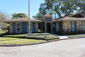
Belle Isle, Florida
City in Florida, United States
Distance: Approx. 4281 meters
Latitude and longitude: 28.47222222,-81.34916667
Belle Isle is a city in Orange County, Florida, United States. The population was 7,032 at the 2020 census. It is part of the Orlando–Kissimmee–Sanford Metropolitan Statistical Area.

Pine Castle, Florida
Census-designated place in Florida, United States
Distance: Approx. 4710 meters
Latitude and longitude: 28.46833333,-81.375
Pine Castle is a census-designated place and unincorporated area in Orange County, Florida, United States. It is part of the Orlando–Kissimmee–Sanford, Florida Metropolitan Statistical Area.

Sky Lake, Florida
Census-designated place in Florida, United States
Distance: Approx. 5291 meters
Latitude and longitude: 28.46083333,-81.39166667
Sky Lake is a census-designated place (CDP) and an unincorporated area in Orange County, Florida, United States. The population was 6,153 at the 2010 census. It is part of the Orlando-Kissimmee, Florida Metropolitan Statistical Area.

Taft, Florida
Census-designated place in Florida, United States
Distance: Approx. 2087 meters
Latitude and longitude: 28.42888889,-81.36777778
Taft is a census-designated place and an unincorporated area in Orange County, Florida, United States. The population was 2,205 at the 2010 census. It is part of the Orlando–Kissimmee Metropolitan Statistical Area.

Orlando International Airport
Airport in Florida, United States
Distance: Approx. 3782 meters
Latitude and longitude: 28.42944444,-81.30888889
Orlando International Airport (IATA: MCO, ICAO: KMCO, FAA LID: MCO) is the primary international airport located 6 miles (9.7 km) southeast of Downtown Orlando, Florida. In 2021, it had 19,618,838 enplanements, making it the busiest airport in the state and seventh busiest airport in the United States. The airport code MCO stands for the airport's former name, McCoy Air Force Base, a Strategic Air Command (SAC) installation, that was closed in 1975 as part of a general military drawdown following the end of the Vietnam War.

The Florida Mall
Shopping mall in Orlando, Florida, United States
Distance: Approx. 4920 meters
Latitude and longitude: 28.44592,-81.39554
The Florida Mall is a super regional enclosed shopping mall located south of Orlando in unincorporated Orange County, Florida, United States, on the southeast corner of Orange Blossom Trail and Sand Lake Road; it opened in 1986. The mall features JCPenney, Dillard's, Macy's, Dick's Sporting Goods, and Sears, in addition to the Crayola Experience. The facility was developed by a Joint Venture of Eddie DeBartolo of DeBartolo Realty & JCP Realty, Inc.

McCoy Air Force Base
Former US Air Force base 10 miles SE of Orlando, FL, later became Orlando International Airport
Distance: Approx. 3782 meters
Latitude and longitude: 28.42944444,-81.30888889
McCoy AFB (1940–1947, 1951–1975) is a former U.S. Air Force installation located 10 miles (16 km) southeast of Orlando, Florida. It was a training base during World War II. From 1951 to 1975, it was a frontline Strategic Air Command (SAC) base during the Cold War and Vietnam War. It was Orlando's biggest employer and economic backbone prior to the opening of Walt Disney World in 1971.

B-52 Memorial Park
Distance: Approx. 3807 meters
Latitude and longitude: 28.44972222,-81.31277778
B-52 Memorial Park is located within the Orlando International Airport just off the Beachline Expressway formerly the Bee Line near runway 18L. It is a small, relatively hidden park under the control of the Greater Orlando Aviation Authority (GOAA) and features a retired B-52D Stratofortress, Air Force Serial Number 56-0687, from the Strategic Air Command. The aircraft was at one time assigned to the 306th Bomb Wing of the now defunct McCoy Air Force Base. The bomber was built in 1956 and retired 28 years later in 1984.
Oak Ridge High School (Orlando, Florida)
High school in Orlando, Florida
Distance: Approx. 5576 meters
Latitude and longitude: 28.47174,-81.384392
Oak Ridge High School is a public high school in Orlando, Florida, established in 1959. The school had been rated a D or F institution by the state starting in 2000. In 2012, the school was awarded a C grade, breaking the low performance streak.
Southern Technical College
Distance: Approx. 5392 meters
Latitude and longitude: 28.448515,-81.399679
Southern Technical College is a private for-profit technical college with multiple locations in Florida. It was founded in 2001 and provides diploma and associate degree programs. Southwest Florida College merged into Southern Technical College in 2014.

Sand Lake Road station
Railway station in Florida, United States
Distance: Approx. 2860 meters
Latitude and longitude: 28.4530604,-81.3665401
Sand Lake Road station is a train station in the Pine Castle area of Orange County, Florida. The station serves SunRail, the commuter rail service of Central Florida. The station was the southern terminus of SunRail up until July 30, 2018, when service was extended south to Poinciana.
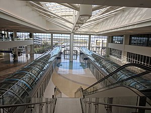
Orlando International Airport Intermodal Terminal
Intermodal transport hub in Orlando, Florida
Distance: Approx. 4381 meters
Latitude and longitude: 28.41453,-81.30818
The Orlando International Airport Intermodal Terminal, also known as the Brightline Orlando Station and South Airport Intermodal Terminal, is an intermodal passenger transport hub located at Orlando International Airport in Orlando, Florida. The complex, which was partially funded by the Florida Department of Transportation, is the current terminus of Brightline, an inter-city rail service which provides service to Miami via the Florida East Coast Railway. The terminal building and the adjacent parking garage opened on November 17, 2017.
Weather in this IP's area
moderate rain
23 Celsius
24 Celsius
22 Celsius
24 Celsius
1007 hPa
95 %
1007 hPa
1004 hPa
10000 meters
6.17 m/s
60 degree
100 %
07:21:37
19:04:13