Country:
 USA
USARegion:
City:
Latitude and Longitude:
Time Zone:
Postal Code:
IP information under different IP Channel
ip-api
Country
Region
City
ASN
Time Zone
ISP
Blacklist
Proxy
Latitude
Longitude
Postal
Route
IPinfo
Country
Region
City
ASN
Time Zone
ISP
Blacklist
Proxy
Latitude
Longitude
Postal
Route
MaxMind
Country
Region
City
ASN
Time Zone
ISP
Blacklist
Proxy
Latitude
Longitude
Postal
Route
Luminati
Country
USRegion
mn
City
minneapolis
ASN
Time Zone
America/Chicago
ISP
Cato Networks Ltd
Latitude
Longitude
Postal
db-ip
Country
Region
City
ASN
Time Zone
ISP
Blacklist
Proxy
Latitude
Longitude
Postal
Route
ipdata
Country
Region
City
ASN
Time Zone
ISP
Blacklist
Proxy
Latitude
Longitude
Postal
Route
Popular places and events near this IP address
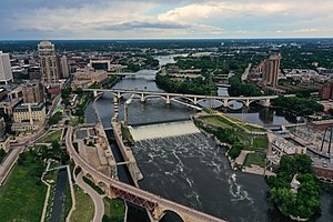
Saint Anthony Falls
Waterfall in Mississippi River into the Mississippi River Gorge in Minneapolis, Minnesota
Distance: Approx. 342 meters
Latitude and longitude: 44.98166667,-93.25861111
Saint Anthony Falls, or the Falls of Saint Anthony (Dakota: Owámniyomni, lit. 'whirlpool'), located at the northeastern edge of downtown Minneapolis, Minnesota, was the only natural major waterfall on the Mississippi River. Throughout the mid-to-late 1800s, various dams were built atop the east and west faces of the falls to support the milling industry that spurred the growth of the city of Minneapolis. In 1880, the central face of the falls was reinforced with a sloping timber apron to stop the upstream erosion of the falls.

Hennepin Avenue Bridge
Bridge in Minneapolis, Minnesota
Distance: Approx. 248 meters
Latitude and longitude: 44.98527778,-93.26388889
The Hennepin Avenue Bridge is the structure that carries Hennepin County State Aid Highway 52, Hennepin Avenue, across the Mississippi River in Minneapolis, Minnesota, at Nicollet Island. Officially, it is the Father Louis Hennepin Bridge, in honor of the 17th-century explorer Louis Hennepin, who was the first European to see the Saint Anthony Falls, a short distance downriver. Two of the three previous structures have been suspension bridges, while a third—which existed nearly a century—was composed of steel arch spans.
Walden University
American for-profit online university
Distance: Approx. 367 meters
Latitude and longitude: 44.98111111,-93.26555556
Walden University is a private for-profit online university headquartered in Minneapolis, Minnesota. It offers bachelor's, master's, doctoral, and specialist degrees. The university is owned by Adtalem Global Education, which purchased the university in August 2021.

Third Avenue Bridge (Minneapolis)
Bridge in Minnesota, United States
Distance: Approx. 261 meters
Latitude and longitude: 44.98333333,-93.25888889
The Third Avenue Bridge is a landmark structure of the city of Minneapolis, Minnesota, United States, originally known as the St. Anthony Falls Bridge. It carries road traffic across the Mississippi River and upper fringes of Saint Anthony Falls.
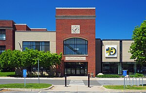
DeLaSalle High School (Minneapolis)
Private, coeducational school in Minneapolis, , Minnesota
Distance: Approx. 370 meters
Latitude and longitude: 44.98666667,-93.26305556
DeLaSalle High School ( DEE-lə-SAL) is a Catholic, college preparatory high school in Minneapolis, Minnesota. It is located on Nicollet Island.

Merriam Street Bridge
Bridge in Minnesota
Distance: Approx. 334 meters
Latitude and longitude: 44.98583333,-93.25972222
Merriam Street Bridge is a truss bridge that spans the east channel of the Mississippi River between Nicollet Island and the east bank of the river in Minneapolis. The bridge was originally built in 1887 by King Iron Bridge Company as one of the four spans of the Broadway Avenue Bridge. When the Broadway Avenue Bridge was reconstructed in 1987, one span was preserved and moved to Nicollet Island.

Martin Olav Sabo Post Office
Post office in MN, United States
Distance: Approx. 223 meters
Latitude and longitude: 44.983265,-93.265032
The Martin Olav Sabo Post Office is the central post office for the city of Minneapolis, Minnesota in the United States. Located on the west bank of the Mississippi River, the facility extends west to east from Hennepin Avenue Bridge to the Third Avenue Bridge and north to south from the West River Parkway on the Grand Rounds Scenic Byway to First Street. Its ZIP code is 55401.

St. Anthony Falls Historic District
United States historic place
Distance: Approx. 342 meters
Latitude and longitude: 44.98166667,-93.25861111
The following are all the contributing resources to the Saint Anthony Falls Historic District in Minneapolis, Minnesota, United States. The District is listed on the National Register of Historic Places, thus these properties are on the NRHP. The "period of significance" of the District was 1858–1941. The district's archaeological record is considered to be one of the most-endangered historic sites in Minnesota.
Minneapolis Fire Department
Fire department in Minneapolis
Distance: Approx. 352 meters
Latitude and longitude: 44.98333333,-93.26666667
The Minneapolis Fire Department provides fire protection and first responder emergency medical services to the city of Minneapolis, Minnesota.
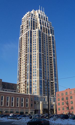
The Carlyle
Distance: Approx. 175 meters
Latitude and longitude: 44.98194444,-93.26305556
The Carlyle is a 469 ft (143 m) tall skyscraper in Minneapolis, Minnesota, USA, located at 100 Third Avenue South. Completed in 2007, The Carlyle has 41 floors and 249 units. It is the 14th-tallest building in Minneapolis, and the 2nd tallest residential building in Minnesota.

Churchill Apartments
Apartment building in downtown Minneapolis, MN
Distance: Approx. 236 meters
Latitude and longitude: 44.98263889,-93.265
Churchill Apartments is a 310-ft (95 m) skyscraper in Minneapolis, Minnesota. It was built in 1981 and has 33 floors. It is the 38th-tallest building in the city.
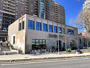
Owamni
Restaurant in Minneapolis, Minnesota, U.S.
Distance: Approx. 296 meters
Latitude and longitude: 44.98111111,-93.26027778
Owamni by the Sioux Chef, or simply Owamni, is a Native American restaurant in downtown Minneapolis, Minnesota, that overlooks the Mississippi River. Owamni's majority Native American staff serves a menu made from indigenous ingredients such as game meats, corn, and wild plants. The restaurant does not serve ingredients that were introduced to the region by Europeans, including butter, dairy, sugar, black pepper, wheat, chicken, beef, and pork.
Weather in this IP's area
clear sky
20 Celsius
19 Celsius
19 Celsius
22 Celsius
1016 hPa
37 %
1016 hPa
988 hPa
10000 meters
5.14 m/s
280 degree
07:18:59
18:42:09