Country:
 USA
USARegion:
City:
Latitude and Longitude:
Time Zone:
Postal Code:
IP information under different IP Channel
ip-api
Country
Region
City
ASN
Time Zone
ISP
Blacklist
Proxy
Latitude
Longitude
Postal
Route
IPinfo
Country
Region
City
ASN
Time Zone
ISP
Blacklist
Proxy
Latitude
Longitude
Postal
Route
MaxMind
Country
Region
City
ASN
Time Zone
ISP
Blacklist
Proxy
Latitude
Longitude
Postal
Route
Luminati
Country
USRegion
or
City
portland
ASN
Time Zone
America/Los_Angeles
ISP
AMAZON-AS
Latitude
Longitude
Postal
db-ip
Country
Region
City
ASN
Time Zone
ISP
Blacklist
Proxy
Latitude
Longitude
Postal
Route
ipdata
Country
Region
City
ASN
Time Zone
ISP
Blacklist
Proxy
Latitude
Longitude
Postal
Route
Popular places and events near this IP address

Eastbank Esplanade
Pedestrian and bicycle path
Distance: Approx. 184 meters
Latitude and longitude: 45.523718,-122.666149
The Eastbank Esplanade (officially Vera Katz Eastbank Esplanade) is a pedestrian and bicycle path along the east shore of the Willamette River in Portland, Oregon, United States. Running through the Kerns, Buckman, and Hosford-Abernethy neighborhoods, it was conceived as an urban renewal project to rebuild the Interstate 5 bicycle bypass washed out by the Willamette Valley Flood of 1996. It was renamed for former Portland mayor Vera Katz in November 2004 and features a statue of her near the Hawthorne Bridge.

Portland Saturday Market
Outdoor arts and crafts market in Portland, Oregon
Distance: Approx. 222 meters
Latitude and longitude: 45.5225,-122.6699
The Portland Saturday Market is an outdoor arts and crafts market in Portland, Oregon. It is the largest continuously operated outdoor market in the United States. It is held every Saturday and Sunday from the beginning of March through December 24, in Tom McCall Waterfront Park underneath Burnside Bridge and south of the bridge, as well as within an adjacent plaza just across Naito Parkway, extending west to the Skidmore Fountain.

Old Town/Chinatown station
Distance: Approx. 250 meters
Latitude and longitude: 45.525,-122.67138889
Old Town/Chinatown station is a MAX Light Rail station served by the Blue and Red Lines. It is located in the Old Town Chinatown neighborhood in Portland, Oregon and is currently the 6th stop eastbound on the Eastside MAX. It is also the last stop before crossing the Willamette River. It is next to the Portland Downtown Heliport.

Portland Downtown Heliport
Airport in Portland, Oregon
Distance: Approx. 231 meters
Latitude and longitude: 45.52527778,-122.67092778
Portland Downtown Heliport (FAA LID: 61J) is a public heliport located in the Old Town Chinatown neighborhood in the northwest section of the city of Portland, Multnomah County, Oregon, United States. It occupies the roof of a 1989 parking garage located at the intersection of NW Naito Parkway and NW Davis Street, not far from the Steel Bridge over the Willamette River. The Downtown Heliport currently has the distinction of being Oregon's only public use heliport.
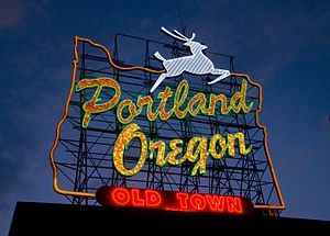
White Stag sign
Sign in Portland, Oregon, U.S.
Distance: Approx. 189 meters
Latitude and longitude: 45.52338611,-122.67051944
The White Stag sign, also known as the "Portland Oregon" sign, is a lighted neon-and-incandescent-bulb sign located atop the White Stag Building, at 70 NW Couch Street in downtown Portland, Oregon, United States, facing the Burnside Bridge. The sign faces westbound traffic as it enters downtown Portland coming across the Willamette River. The sign was acquired by the City of Portland in September 2010, and the lettering was changed to read "Portland Oregon" in November 2010.
Sculpture Stage
Sculpture in Portland, Oregon
Distance: Approx. 207 meters
Latitude and longitude: 45.522476,-122.669406
Sculpture Stage is an outdoor 1976 stainless steel sculpture by Bruce West, located in Tom McCall Waterfront Park in downtown Portland, Oregon. The work was funded by the Comprehensive Employment and Training Act and is part of the City of Portland and Multnomah County Public Art Collection courtesy of the Regional Arts & Culture Council.
Packy mural
Former outdoor mural in Portland, Oregon, U.S.
Distance: Approx. 242 meters
Latitude and longitude: 45.52283,-122.67081
The Packy mural was a public artwork depicting the elephant Packy, painted on the Skidmore Fountain Building in Portland, Oregon's Old Town Chinatown neighborhood. The artwork was designed by Eric Larsen and painted in 1990 by North Pacific Sign and Design, but was destroyed during the building's 2008 renovation to become the new headquarters for Mercy Corps. The mural received a generally positive reception, though in 1997 the president of the company that owned the building expressed his desire to replace the artwork, which he considered a free advertisement for the Oregon Zoo.

Japanese American Historical Plaza
Public plaza in Portland, Oregon, U.S.
Distance: Approx. 104 meters
Latitude and longitude: 45.52393,-122.66967
Japanese American Historical Plaza is a plaza in Portland, Oregon's Tom McCall Waterfront Park, located where the Portland Japantown once stood.

Blagen Block
Building in Portland, Oregon, U.S.
Distance: Approx. 215 meters
Latitude and longitude: 45.52366667,-122.67105556
The Blagen Block is an historic building in Portland, Oregon's Old Town Chinatown neighborhood, in the United States. The four-story building was designed by Warren H. Williams and completed in 1888. In 1970, the city's Historic Landmarks Commission designated the Blagen Block as a Portland Historic Landmark.

White Stag Block
Building complex in Portland, Oregon, U.S.
Distance: Approx. 190 meters
Latitude and longitude: 45.5235,-122.67062
The White Stag Block facility refers to the Bickel Block Building, the Skidmore Block Building, and the White Stag Building, in Portland, Oregon's Old Town Chinatown neighborhood, in the United States. It was purchased by the University of Oregon Foundation in 2015.

Kevin Duckworth Memorial Dock
Dock in Portland, Oregon, U.S.
Distance: Approx. 205 meters
Latitude and longitude: 45.52480556,-122.66591667
The Kevin J. Duckworth Memorial Dock is a dock on the Willamette River, along Portland, Oregon's Eastbank Esplanade.

Ankeny pumping station
Pumping station in Portland, Oregon, U.S.
Distance: Approx. 185 meters
Latitude and longitude: 45.52267727,-122.66935106
The Ankeny pumping station, or Ankeny sewage pumping station, is a 10,000-gallon pumping station in Portland, Oregon's Tom McCall Waterfront Park.
Weather in this IP's area
scattered clouds
23 Celsius
22 Celsius
21 Celsius
25 Celsius
1014 hPa
56 %
1014 hPa
1014 hPa
10000 meters
4.12 m/s
300 degree
40 %
06:54:44
19:13:51