Country:
Region:
City:
Latitude and Longitude:
Time Zone:
Postal Code:
IP information under different IP Channel
ip-api
Country
Region
City
ASN
Time Zone
ISP
Blacklist
Proxy
Latitude
Longitude
Postal
Route
Luminati
Country
ASN
Time Zone
Asia/Singapore
ISP
OVH SAS
Latitude
Longitude
Postal
IPinfo
Country
Region
City
ASN
Time Zone
ISP
Blacklist
Proxy
Latitude
Longitude
Postal
Route
db-ip
Country
Region
City
ASN
Time Zone
ISP
Blacklist
Proxy
Latitude
Longitude
Postal
Route
ipdata
Country
Region
City
ASN
Time Zone
ISP
Blacklist
Proxy
Latitude
Longitude
Postal
Route
Popular places and events near this IP address

Thian Hock Keng
Mazu temple in Singapore
Distance: Approx. 209 meters
Latitude and longitude: 1.28105556,103.84752778
Thian Hock Keng (Chinese: 天福宮; pinyin: Tiānfú Gōng; Pe̍h-ōe-jī: Thian-hok-keng or the Tianfu Temple, literally "Palace of Heavenly Happiness"), is a temple built for the worship of Mazu, a Chinese sea goddess, located in Singapore. It is the oldest and most important temple of the Hokkien (Hoklo) people in the country. Another shrine at the back is Buddhist dedicated to Guanyin, the Mahayana Buddhist bodhisattva of mercy.

Telok Ayer MRT station
Mass Rapid Transit station in Singapore
Distance: Approx. 256 meters
Latitude and longitude: 1.282125,103.848472
Telok Ayer MRT station is an underground Mass Rapid Transit (MRT) station on the Downtown line (DTL). Situated in Outram, Singapore, the station serves various offices and commercial developments around the junction of Cross Street and Telok Ayer Street. The station is operated by SBS Transit.
Nagore Durgha, Singapore
Place in Singapore
Distance: Approx. 214 meters
Latitude and longitude: 1.28141667,103.84783333
The Nagore Dargah (or Nagore Dargah) is a shrine in Singapore built by Muslims from southern India between 1828 and 1830, and was originally known as Shahul Hamid Dargah. When this shrine was first built, Telok Ayer Street where the shrine is located was a sandy beach crowded with sailing craft. While its physical surroundings have changed beyond recognition, the monument itself – save for conservation and preservation work in 2007 – has changed little since the late 19th century.
Masjid Al-Abrar
Mosque in Singapore
Distance: Approx. 203 meters
Latitude and longitude: 1.280278,103.847222
Masjid Al-Abrar (Malay for Al-Abrar Mosque; Jawi:مسجد الأبرار) is a mosque located along Telok Ayer Street in Chinatown within the Central Area, Singapore. It is one of the earliest mosques in Singapore. The building was gazetted as a national monument on 19 November 1974.
Lau Pa Sat
Historic building in Singapore used as a food centre
Distance: Approx. 176 meters
Latitude and longitude: 1.280629,103.850396
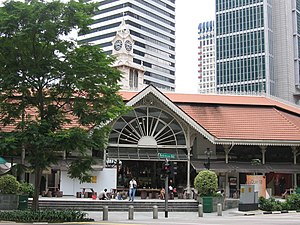
Lau Pa Sat (Chinese: 老巴刹; pinyin: Lǎo Bāshā; lit. 'Old Market'), also known as Telok Ayer Market (Malay: Pasar Telok Ayer; Chinese: 直落亚逸巴刹), is a historic building located within the Downtown Core in the Central Area of Singapore. It was first built in 1824 as a fish market on the waterfront serving the people of early colonial Singapore and rebuilt in 1838.
SGX Centre
Commercial offices in Downtown Core, Singapore
Distance: Approx. 126 meters
Latitude and longitude: 1.279042,103.84975
SGX Centre is a twin tower high-rise complex in the city of Singapore. The development consists of two 187 m (614 ft) skyscrapers, located in Shenton Way. The two towers are named SGX Centre One and SGX Centre Two, and are situated together on an elongated, rectangular site.

One Shenton Way
Residential in Downtown Core, Singapore
Distance: Approx. 186 meters
Latitude and longitude: 1.2792538,103.8505465
One Shenton is a high end real estate redevelopment project with 341 apartments along Shenton Way in the Tanjong Pagar area of Singapore. It consists of two towers, the tallest of which is 50 stories. It was completed in 2011 and is notable for its two tower construction.

UIC Building
Commercial offices in Shenton Way, Singapore
Distance: Approx. 229 meters
Latitude and longitude: 1.27791944,103.84958056
The UIC Building (United Industrial Corporation Limited Building) was a former 40-storey, 152 m (499 ft) skyscraper in the city-state of Singapore.

Straits View
Planning Area in Central ----, Singapore
Distance: Approx. 222 meters
Latitude and longitude: 1.2787,103.8506
Straits View is a planning area located in the Central Area of the Central Region of Singapore. The area is currently relatively undeveloped, with fewer commercial developments compared to the adjacent Downtown Core. Straits View planning area is bounded by Marina South to the north, the Downtown Core to the northwest and west, and the Singapore Strait to the south.

CapitaGreen
Commercial offices in Downtown Core, Singapore
Distance: Approx. 266 meters
Latitude and longitude: 1.2819,103.8503
CapitaGreen, also known as Market Street Tower, is an office tower located in Raffles Place, Singapore. The building was designed by Toyo Ito and completed in 2014. With a height of 245 m (804 ft), it is one of the tallest skyscrapers in Singapore.

A Noodle Story
Street food stall in Singapore
Distance: Approx. 267 meters
Latitude and longitude: 1.279352,103.846666
A Noodle Story is a street food stall in the Amoy Street Food Centre in Singapore. The food stall was awarded the Michelin Bib Gourmand in 2017. A new outlet in the Guoco Tower was opened in 2021.
Shenton House, Singapore
Distance: Approx. 180 meters
Latitude and longitude: 1.2787,103.8501
Shenton House is a building on Shenton Way in the Central Area of Singapore featuring a shopping podium underneath a 20-storey commercial tower. It was among the first buildings in Singapore to feature such a design.
Weather in this IP's area
light rain
26 Celsius
27 Celsius
25 Celsius
26 Celsius
1011 hPa
92 %
1011 hPa
1007 hPa
10000 meters
1.03 m/s
40 degree
75 %
06:46:04
18:50:11


